Location
Latitude: |
31-28-01.7000N (31.467139) |
Longitude: |
089-20-13.4000W (-89.337056) |
Elevation: |
297.6 feet MSL (91 m MSL) |
Magnetic Variation: |
2 W (as of April 2024 from WMM2020 model) |
Time Zone: |
UTC -6.0 (Standard Time) UTC -5.0 (Daylight Savings Time) |
From City: |
09 N.M. N of Hattiesburg/Laurel, Mississippi |
Found On: |
New Orleans Chart |
FAA Region: |
ASO |
Contacts
Manager: |
Publicly owned: |
| THOMAS HEANUE 1002 TERMINAL DR MOSELLE, MS 39459 601-545-3111 |
REGIONAL AIRPORT AUTH 1002 TERMINAL DR MOSELLE, MS 39459 601-545-3111 |
Operations
Airport Status: |
Operational |
Facility Use: |
Public |
Type: |
Airport |
Activation Date: |
05/1974 |
Control tower: |
No |
Attendance (Months/Days/Hours): |
Months/Days/Hours ALL/ALL/0500-2300 |
Boundary ARTCC: |
ZHU (Houston) |
Responsible ARTCC: |
ZHU (Houston) |
Lighting Schedule: |
SEE RMK |
Segmented Circle Indicator: |
Yes |
Traffic Pattern Altitude (MSL): |
1298 feet (396 m) |
NOTAMs Facility: |
PIB |
NOTAM-D Service: |
Yes |
International Airport of Entry: |
No |
Customs Landing Rights: |
No |
Military Landing Rights: |
Yes |
Civil/Military Joint Use: |
No |
Aircraft Rescue and Firefighting: |
Class I ARFF Index: A Air Carrier Service: Scheduled Certification Date: 06/1974 |
Based Aircraft
| Single Engine: | 42 |
| Multi Engine: | 8 |
| Jet Engine: | 8 |
| GA Helicopters: | 1 |
Annual Operations (as of 01/31/2023)
| Total Operations: | 41371 | |
| Commercial: | 1252 | 3.0% |
| GA Local: | 21360 | 51.6% |
| GA Itinerant: | 18432 | 44.6% |
| Military Aircraft: | 327 | 0.8% |
Communications
| CTAF: | 123.000 |
| Unicom: | 123.000 |
| AWOS-3PT: | 128.325 (601-584-6701) |
- APCH/DEP SVC PRVDD BY HOUSTON ARTCC (ZHU) ON FREQS 126.8/327.8 (HATTIESBURG RCAG).
Fixed Based Operators (FBOs) & Fuel
(Click on a business for detail)
Please help us keep this information up to date. This is a FREE SERVICE just like everything else on Airport Guide! If you see that a business needs to be added, modified, or deleted please fill out our Update Form.
To add, modify, or delete a business click here.
Please help us keep this information up to date. This is a FREE SERVICE just like everything else on Airport Guide! If you see that a business needs to be added, modified, or deleted please fill out our Update Form.
Area Code: 601 |
| Business Name | Frequency | Phone | Fuel Grade |
|---|---|---|---|
| U.S. Aviation Corporation
Update FBO info |
Unicom 123.0 | 544-0951 | 100LL, Jet A |
Flight Service Stations
| Primary | Alternate | |
| FSS on Field: | N | |
| FSS Name (ID): | Greenwood(GWO) | |
| Frequency: | ||
| Toll Free Phone: | 1-800-WX-BRIEF |
Instrument Procedures / Charts
FAA Terminal Procedures valid from 0901Z 03/21/24 to 0901Z 04/18/24.
There are various types of charts available for an airport. They are listed in the Page Type column. Here is a legend for those types:
APD - Airport Diagram
DP - Departure Procedure Charts
HOT - Hot Spots
IAP - Instrument Approach Procedure Charts
MIN - Minimums
STAR - Standard Terminal Arrival Charts
| Page Type | Page Name | Volume | Action Since Last Cycle |
|---|---|---|---|
| IAP | ILS OR LOC RWY 18 | SC-4 | |
| IAP | RNAV (GPS) RWY 18 | SC-4 | |
| IAP | RNAV (GPS) RWY 36 | SC-4 | |
| IAP | VOR-A | SC-4 | |
| MIN | ALTERNATE MINIMUMS | SC-4 | |
| MIN | TAKEOFF MINIMUMS | SC-4 |
Terminal Procedures are only available for airports in several countries with more being added all the time. If you are looking for a specific country's charts, please send an email to support(at)airportguide.com stating the country name. This will be used to prioritize the implementation.
Navigation Aids (Navaids) near PIB
| Dist (NM) | ID | Morse Code | Name | Type | Freq | True Hdg | Mag Hdg |
|---|---|---|---|---|---|---|---|
| 2.9 | LBY | . _ . . _ . . . _ . _ _ | Eaton | VORTAC | 110.60 | 180 | 182 |
| 15.2 | THJ | _ . . . . . _ _ _ | Tallahala | NDB | 346 | 29 | 31 |
| 44.3 | GVB | _ _ . . . . _ _ . . . | Bogalusa | NDB | 353 | 217 | 219 |
| 48.2 | MCB | _ _ _ . _ . _ . . . | Mc Comb | VORTAC | 116.70 | 258 | 260 |
| 48.9 | GCV | _ _ . _ . _ . . . . _ | Greene County | VORTAC | 115.70 | 116 | 118 |
| 55.0 | ME | _ _ . | Savoy | NDB | 356 | 31 | 33 |
| 58.0 | PCU | . _ _ . _ . _ . . . _ | Picayune | VOR-DME | 113.95 | 200 | 202 |
| 59.6 | GP | _ _ . . _ _ . | Bayou | NDB | 360 | 171 | 173 |
| 61.0 | MEI | _ _ . . . | Meridian | VORTAC | 117.00 | 26 | 28 |
| 61.3 | HS | . . . . . . . | Hanco | NDB | 221 | 185 | 187 |
| 61.5 | MC | _ _ _ . _ . | Ferni | NDB | 413 | 258 | 260 |
| 62.7 | JAN | . _ _ _ . _ _ . | Jackson | VOT | 111.00 | 323 | 325 |
| 65.0 | GPT | _ _ . . _ _ . _ | Gulfport | VORTAC | 109.00 | 168 | 170 |
| 67.0 | BIX | _ . . . . . _ . . _ | Keesler | TACAN | 111.80 | 161 | 163 |
| 67.1 | SJI | . . . . _ _ _ . . | Semmes | VORTAC | 115.30 | 131 | 133 |
| 68.0 | MOB | _ _ _ _ _ _ . . . | Wisle | NDB | 248 | 128 | 130 |
| 69.3 | JA | . _ _ _ . _ | Allen | NDB | 365 | 325 | 327 |
| 69.8 | MHZ | _ _ . . . . _ _ . . | Magnolia | VORTAC | 113.20 | 326 | 328 |
| 70.2 | EWA | . . _ _ . _ | Kewanee | DME | 113.8 | 39 | 41 |
| 73.7 | JH | . _ _ _ . . . . | Brenz | NDB | 260 | 320 | 322 |
Nearby Airports with Fuel
Notices to Airmen (NOTAMS)
Remarks
| A11 | HATTIESBURG-LAUREL REGIONAL AIRPORT AUTHORITY. |
| A110*G | THIS AIRPORT HAS BEEN SURVEYED BY THE NATIONAL GEODETIC SURVEY. |
| A110-1 | FOR CD CTC HOUSTON ARTCC AT 281-230-5622. |
| A26 | CLSD TO ACR OPS WITH MORE THAN 30 PAX SEATS EXCP 24 HR PPR, CALL ARPT MGR 601-545-3111. |
| A81-APT | ACTVT MALSR RWY 18; REILS RWY 18 & 36; HIRL RWY 18/36 - CTAF. HIRL RWY 18/36 PRESET TO MED INTST, TO INCRS INTST - CTAF. PAPIS RWY 18 & 36 OPR CONSLY. |
Runways
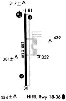
Runway Summary
| Runways: | 18/36 |
| Longest Runway: | 18/36 is 6502 ft (1982 m) long |
| Runways with an Instrument Approach: | 18 |
PIB Airport Runway Details
| Runway 18/36 | 6502 ft x 150 ft (1982 m x 46 m) | |
| Surface: | Asphalt - Good condition - Saw-cut or plastic grooved | |
| Runway Pavement Class: | 72 /F/B/X/T | |
| Runway Edge Lights: | High Intensity | |
Runway Weight Bearing Capacity (in thousands of pounds) |
||
| Single Wheel Landing Gear: | 125.0 | |
| Dual Wheel Landing Gear: | 225.0 | |
| Dual Tandem Wheel Landing Gear: | 275.0 | |
Runway 18 |
Runway 36 |
|
Elevation: |
297.6 | 293.9 |
Latitude: |
31-28-33.9037N | 31-27-29.5549N |
Longitude: |
089-20-13.4480W | 089-20-13.3667W |
|
Runway True Alignment: |
180 | 360 |
ILS Type: |
ILS | |
Glide Path Angle: |
3.0 degrees | 3.0 degrees |
Traffic Pattern: |
Left | Left |
Runway Markings Type: |
Precision Instrument | Precision Instrument |
Runway Markings Condition: |
Good | Good |
Visual Glide Slope Indicators: |
4-Light PAPI On Left Side Of Runway | 4-Light PAPI On Left Side Of Runway |
Approach Light System: |
1,400 Foot Medium Intensity Approach Lighting System With Runway Alignment Indicator Lights | |
REIL: |
Yes | Yes |
Threshold Crossing Height: |
58 | 44 |
Declared Distances |
||
Take Off Run Avbl. (TORA): |
6502 | 6502 |
Take Off Distance Avbl. (TODA): |
6502 | 6502 |
Actual Stop Dist. Avbl. (ASDA): |
6502 | 6502 |
Landing Dist. Avbl. (LDA): |
6502 | 6502 |
Services
Airframe Repair: |
Minor |
Powerplant Repair: |
Minor |
Bottled Oxygen: |
None |
Bulk Oxygen: |
None |
Fuel Available: |
100LL |
Landing Fees: |
No |
Parking: |
Tiedowns available |
Maps & Diagrams
PIB Sectional
Flight Planning
at skyvector.com
at skyvector.com