Location
Latitude: |
42-10-12.4548N (42.170126) |
Longitude: |
112-17-33.6453W (-112.292679) |
Elevation: |
4503.0 feet MSL (1373 m MSL) |
Magnetic Variation: |
11.3 E (as of April 2024 from WMM2020 model) |
Time Zone: |
UTC -7.0 (Standard Time) UTC -6.0 (Daylight Savings Time) |
From City: |
03 N.M. SW of Malad City, Idaho |
Found On: |
Salt Lake City Chart |
FAA Region: |
ANM |
Contacts
Manager: |
Publicly owned: |
| CHASE ALBRETSEN 368 N MAIN ST MALAD CITY, ID 83252 208-604-3680 |
ONEIDA COUNTY 10 COURT ST MALAD CITY, ID 83252 208-766-4116 |
Operations
Airport Status: |
Operational |
Facility Use: |
Public |
Type: |
Airport |
Activation Date: |
03/1945 |
Control tower: |
No |
Attendance (Months/Days/Hours): |
Months/Days/Hours Unattended |
Boundary ARTCC: |
ZLC (Salt Lake City) |
Responsible ARTCC: |
ZLC (Salt Lake City) |
Lighting Schedule: |
SEE RMK |
Segmented Circle Indicator: |
Yes |
Traffic Pattern Altitude (MSL): |
5503 feet (1677 m) |
NOTAMs Facility: |
MLD |
NOTAM-D Service: |
Yes |
Military Landing Rights: |
No |
Civil/Military Joint Use: |
No |
Based Aircraft
| Single Engine: | 1 |
Annual Operations (as of 05/30/2022)
| Total Operations: | 4425 | |
| GA Local: | 200 | 4.5% |
| GA Itinerant: | 4200 | 94.9% |
| Military Aircraft: | 25 | 0.6% |
Communications
| CTAF: | 122.900 |
Fixed Based Operators (FBOs) & Fuel
(Click on a business for detail)
Please help us keep this information up to date. This is a FREE SERVICE just like everything else on Airport Guide! If you see that a business needs to be added, modified, or deleted please fill out our Update Form.
To add, modify, or delete a business click here.
Please help us keep this information up to date. This is a FREE SERVICE just like everything else on Airport Guide! If you see that a business needs to be added, modified, or deleted please fill out our Update Form.
Area Code: 208 |
| Business Name | Frequency | Phone | Fuel Grade |
|---|---|---|---|
| Oneida County Airport
Update FBO info |
766-4932 | 100LL |
Flight Service Stations
| Primary | Alternate | |
| FSS on Field: | N | |
| FSS Name (ID): | Boise(BOI) | |
| Frequency: | ||
| Toll Free Phone: | 1-800-WX-BRIEF |
Instrument Procedures / Charts
Terminal Procedures are only available for airports in several countries with more being added all the time. If you are looking for a specific country's charts, please send an email to support(at)airportguide.com stating the country name. This will be used to prioritize the implementation.
Navigation Aids (Navaids) near MLD
| Dist (NM) | ID | Morse Code | Name | Type | Freq | True Hdg | Mag Hdg |
|---|---|---|---|---|---|---|---|
| 7.3 | MLD | _ _ . _ . . _ . . | Malad City | VOR-DME | 117.40 | 284 | 273 |
| 25.9 | LHO | . _ . . . . . . _ _ _ | Brigham City | VOR-DME | 112.90 | 150 | 139 |
| 40.4 | BMC | _ . . . _ _ _ . _ . | Brigham City | NDB | 294 | 166 | 155 |
| 44.9 | PIH | . _ _ . . . . . . . | Pocatello | VOR-DME | 112.60 | 339 | 328 |
| 48.6 | PI | . _ _ . . . | Tyhee | NDB | 383 | 348 | 337 |
| 57.4 | OGD | _ _ _ _ _ . _ . . | Ogden | VORTAC | 115.70 | 171 | 160 |
| 64.7 | HIF | . . . . . . . . _ . | Hill | TACAN | 111.20 | 166 | 155 |
| 73.9 | BYI | _ . . . _ . _ _ . . | Burley | VOR-DME | 114.10 | 289 | 277 |
| 75.9 | SWU | . . . . _ _ . . _ | Sweden | NDB | 350 | 4 | 353 |
| 77.5 | EVW | . . . . _ . _ _ | Evanston | VOR-DME | 109.60 | 133 | 122 |
| 80.4 | TCH | _ _ . _ . . . . . | Wasatch | VORTAC | 116.80 | 169 | 158 |
| 81.6 | IDA | . . _ . . . _ | Idaho Falls | VOR-DME | 113.85 | 7 | 356 |
| 84.5 | LCU | . _ . . _ . _ . . . _ | Lucin | VORTAC | 113.60 | 235 | 224 |
| 85.4 | SLC | . . . . _ . . _ . _ . | Salt Lake City | VOT | 111.00 | 170 | 159 |
| 86.8 | ID | . . _ . . | Uconn | NDB | 324 | 8 | 357 |
| 93.3 | TW | _ . _ _ | Strik | NDB | 389 | 282 | 270 |
| 93.6 | TVY | _ . . . _ _ . _ _ | Tooele | NDB | 371 | 181 | 170 |
| 96.2 | FBR | . . _ . _ . . . . _ . | Fort Bridger | VOR-DME | 114.45 | 118 | 107 |
| 99.2 | TWF | _ . _ _ . . _ . | Twin Falls | VORTAC | 113.10 | 281 | 269 |
| 99.8 | BPI | _ . . . . _ _ . . . | Big Piney | VOR-DME | 116.50 | 75 | 64 |
Nearby Airports with Fuel
Notices to Airmen (NOTAMS)
Remarks
| A110-2 | REFLECTORS ON TWY AND RAMP. |
| A110-3 | FOR CD IF UNA TO CTC ON FSS FREQ, CTC SALT LAKE ARTCC AT 801-320-2568. |
| A14 | ROXANNE@HESSPUMICE.COM |
| A32-16/34 | ASPH PAVEMENT IS 60' WIDE, 45' WIDE ASPHALT-TREATED SHOULDERS ON EACH SIDE OF PAVEMENT. |
| A52-16 | PERMANENT +20 FT SPRINKLER LINE. |
| A58-16 | RWY 16 + 3 FT FENCE AT 100 FT & 180 FT ON CNTRLN; 15 FT ROAD AT 160 FT ON CNTRLN. |
| A58-34 | +4' FENCE AT 60' ON CNTRLN; 15' ROAD AT 80' ON CNTRLN. |
| A70-FUEL-10 | 0LL FOR FUEL CALL 208-221-9031. GAS PUMP IS CREDIT CARD OPR. |
| A81-APT | ACTVT MIRL RY 16/34 - CTAF. |
| E111 | ESTABD PRIOR TO 15 MAY 1959. RWY 08/26 NO OBJECTION. |
Runways
Runway Summary
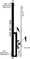
| Runways: | 08/26 16/34 |
| Longest Runway: | 16/34 is 4946 ft (1508 m) long |
| Runways with an Instrument Approach: |
MLD Airport Runway Details
| Runway 08/26 | 3918 ft x 75 ft (1194 m x 23 m) | |
| Runway Length Source: | OWNER as of 04/12/2021 | |
| Surface: | Turf/Dirt - No special surface treatment | |
Runway 08 |
Runway 26 |
|
Elevation: |
4490.0 | 4490.0 |
Latitude: |
42-10-11.0300N | 42-10-10.9100N |
Longitude: |
112-18-15.0300W | 112-17-23.0000W |
Glide Path Angle: |
0.0 degrees | 0.0 degrees |
| Runway 16/34 | 4946 ft x 60 ft (1508 m x 18 m) | |
| Surface: | Turf/Dirt - No special surface treatment | |
| Runway Edge Lights: | Medium Intensity | |
Runway 16 |
Runway 34 |
|
Elevation: |
4503.0 | 4475.0 |
Latitude: |
42-10-38.0600N | 42-09-49.2000N |
Longitude: |
112-17-21.4800W | 112-17-21.4800W |
Glide Path Angle: |
0.0 degrees | 0.0 degrees |
Traffic Pattern: |
Left | Left |
Runway Markings Type: |
Basic | Basic |
Runway Markings Condition: |
Good | Good |
Object at End: |
OTHER | PLINE |
Object Height: |
20 | 45 |
Distance from End: |
900 | 2300 |
Services
Airframe Repair: |
Major |
Powerplant Repair: |
Major |
Bottled Oxygen: |
Low Pressure |
Bulk Oxygen: |
High Pressure |
Fuel Available: |
100LL, Jet A |
Landing Fees: |
No |
Parking: |
Hangars and tiedowns available |
Maps & Diagrams
MLD Sectional
Flight Planning
at skyvector.com
at skyvector.com