Location
Latitude: |
47-02-57.3000N (47.04925) |
Longitude: |
109-28-00.1000W (-109.466694) |
Elevation: |
4170.4 feet MSL (1271 m MSL) |
Magnetic Variation: |
10.8 E (as of April 2024 from WMM2020 model) |
Time Zone: |
UTC -7.0 (Standard Time) UTC -6.0 (Daylight Savings Time) |
From City: |
02 N.M. SW of Lewistown, Montana |
Found On: |
Great Falls Chart |
FAA Region: |
ANM |
Contacts
Manager: |
Publicly owned: |
| BRYON ARMOUR P.O. BOX 343, 190 TERMINAL DRIVE LEWISTOWN, MT 59457 (406) 535-3264 |
LEWISTOWN & FERGUS COUNTY BOX 343 LEWISTOWN, MT 59457 406-535-5119 |
Operations
Airport Status: |
Operational |
Facility Use: |
Public |
Type: |
Airport |
Activation Date: |
04/1940 |
Control tower: |
No |
Attendance (Months/Days/Hours): |
Months/Days/Hours ALL/MON-FRI/0800-1700 |
Boundary ARTCC: |
ZLC (Salt Lake City) |
Responsible ARTCC: |
ZLC (Salt Lake City) |
Lighting Schedule: |
SEE RMK |
Segmented Circle Indicator: |
Yes |
Traffic Pattern Altitude (MSL): |
5170 feet (1576 m) |
NOTAMs Facility: |
LWT |
NOTAM-D Service: |
Yes |
International Airport of Entry: |
No |
Customs Landing Rights: |
No |
Military Landing Rights: |
Yes |
Civil/Military Joint Use: |
No |
Based Aircraft
| Single Engine: | 56 |
| Multi Engine: | 5 |
| GA Helicopters: | 1 |
Annual Operations (as of 05/31/2019)
| Total Operations: | 10300 | |
| Air Taxi: | 1800 | 17.5% |
| GA Local: | 4000 | 38.8% |
| GA Itinerant: | 4000 | 38.8% |
| Military Aircraft: | 500 | 4.9% |
Communications
| CTAF: | 123.000 |
| Unicom: | 123.000 |
| ASOS: | 118.375 (406-538-2653) |
- APCH/DEP CTL SVC PRVDD BY SALT LAKE ARTCC (ZLC) ON 133.4/285.4 (JUDITH MOUNTAIN RCAG).
Fixed Based Operators (FBOs) & Fuel
(Click on a business for detail)
Please help us keep this information up to date. This is a FREE SERVICE just like everything else on Airport Guide! If you see that a business needs to be added, modified, or deleted please fill out our Update Form.
To add, modify, or delete a business click here.
Please help us keep this information up to date. This is a FREE SERVICE just like everything else on Airport Guide! If you see that a business needs to be added, modified, or deleted please fill out our Update Form.
Area Code: 406 |
| Business Name | Frequency | Phone | Fuel Grade |
|---|---|---|---|
| Central Air Service
Update FBO info |
538-3767 | ||
| Newton Aviation
Update FBO info |
Unicom 123.0 | 538-8150, -7892 | 80 100LL Jet A |
| Skycraft, Inc.
Update FBO info |
538-5457 | 100LL |
Flight Service Stations
| Primary | Alternate | |
| FSS on Field: | ||
| FSS Name (ID): | Great Falls(GTF) | |
| Frequency: | ||
| Toll Free Phone: | 1-800-WX-BRIEF |
Instrument Procedures / Charts
FAA Terminal Procedures valid from 0901Z 03/21/24 to 0901Z 04/18/24.
There are various types of charts available for an airport. They are listed in the Page Type column. Here is a legend for those types:
APD - Airport Diagram
DP - Departure Procedure Charts
HOT - Hot Spots
IAP - Instrument Approach Procedure Charts
MIN - Minimums
STAR - Standard Terminal Arrival Charts
| Page Type | Page Name | Volume | Action Since Last Cycle |
|---|---|---|---|
| IAP | RNAV (GPS) RWY 08 | NW-1 | |
| IAP | RNAV (GPS) RWY 26 | NW-1 | |
| IAP | VOR RWY 08 | NW-1 | |
| MIN | ALTERNATE MINIMUMS | NW-1 | |
| MIN | TAKEOFF MINIMUMS | NW-1 |
Terminal Procedures are only available for airports in several countries with more being added all the time. If you are looking for a specific country's charts, please send an email to support(at)airportguide.com stating the country name. This will be used to prioritize the implementation.
Navigation Aids (Navaids) near LWT
| Dist (NM) | ID | Morse Code | Name | Type | Freq | True Hdg | Mag Hdg |
|---|---|---|---|---|---|---|---|
| 5.7 | LWT | . _ . . . _ _ _ | Lewistown | VOR-DME | 115.45 | 272 | 261 |
| 39.8 | HWQ | . . . . . _ _ _ _ . _ | Harlowton | NDB | 242 | 202 | 191 |
| 51.2 | RPX | . _ . . _ _ . _ . . _ | Roundup | NDB | 362 | 132 | 121 |
| 78.6 | BI | _ . . . . . | Saige | NDB | 251 | 155 | 144 |
| 80.0 | ITU | . . _ . . _ | Truly | NDB | 371 | 284 | 273 |
| 82.2 | BIL | _ . . . . . . _ . . | Billings | VORTAC | 114.50 | 154 | 144 |
| 82.8 | GTF | _ _ . _ . . _ . | Great Falls | VORTAC | 115.10 | 287 | 276 |
| 90.3 | HVR | . . . . . . . _ . _ . | Havre | VOR-DME | 114.65 | 352 | 341 |
| 90.3 | LVM | . _ . . . . . _ _ _ | Livingston | VOR-DME | 116.10 | 206 | 195 |
| 98.4 | HAU | . . . . . _ . . _ | Hauser | NDB | 386 | 253 | 242 |
Nearby Airports with Fuel
| Dist (NM) | Name (Airport IDs) | True Hdg | Mag Hdg | Fuel Grade |
|---|---|---|---|---|
| 31.7 | Stanford/Biggerstaff Field Airport (S64) |
280 | 269 | 100LL |
| 51.3 | Roundup Airport (RPX KRPX RPX) |
131 | 121 | 100LL, Jet A-1 |
| 67.3 | Fort Benton Airport (79S) |
315 | 304 | 100LL |
| 68.0 | White Sulphur Springs Airport (7S6) |
241 | 230 | 100LL |
| 71.8 | Big Sandy Airport (3U8) |
338 | 327 | 100LL |
| 77.5 | Big Timber At Howard Field Airport (6S0) |
196 | 185 | 100LL, Jet A |
| 81.7 | Great Falls International Airport (GTF KGTF GTF) |
289 | 277 | 100LL, Jet A |
| 83.7 | Billings Logan International Airport (BIL KBIL BIL) |
152 | 142 | 100LL, Jet A |
| 85.6 | Woltermann Meml Airport (6S3) |
173 | 163 | 100LL |
| 85.8 | Laurel Municipal Airport (6S8) |
159 | 149 | 100LL, Jet A |
| 89.3 | Maddox Ranch Company Airport (3MT4) |
10 | 359 | 100LL |
| 90.4 | Havre City-County Airport (HVR KHVR HVR) |
352 | 341 | 100LL, Jet A+ |
| 90.6 | Mission Field Airport (LVM KLVM LVM) |
206 | 195 | 100LL, Jet A |
| 93.0 | Edgar G Obie Airport (S71) |
5 | 354 | 100LL |
Notices to Airmen (NOTAMS)
Remarks
| A110*G | THIS AIRPORT HAS BEEN SURVEYED BY THE NATIONAL GEODETIC SURVEY. |
| A110-2 | ALL TWYS HAVE REFLECTORS EXCEPT TWY C, E, AND HALF OF A, WHICH ARE LGTD. |
| A110-3 | RY 03/21 DAY USE ONLY. |
| A110-4 | RWY 03/21 NOT MNTND IN WINTER; RWY 13/31 PLOWED AS NEEDED. |
| A110-5 | ARPT SFC CONDS NOT MNTD 1700-0500. |
| A110-6 | BIRDS ON AND INVOF AIRPORT. |
| A110-7 | FOR CD IF UNA TO CTC ON FSS FREQ, CTC SALT LAKE ARTCC AT 801-320-2568. |
| A16 | OR CALL 406-350-3264. |
| A33-03/21 | RY 03/21 ASPH SPALLING. |
| A42-03 | RY 03/21 MARKINGS FADED. |
| A81-APT | ACTVT REIL RWYS 08 & 26; PAPI RWY 08; VASI RWY 26; MIRL RWYS 08/26 & 13/31; - CTAF. |
| E111 | PVD ALL ULTRALIGHTS FLY AT 300'AGL OR LESS WHEN IN CTLZ; AND MAINT A DSTC OF 500' OR GREATER FM THE CL OF ANY ACTV TXY/RWY, EXTD 2 MI FM THE ARPT & TO THE GND ON ANY ACTV RWY; ALL ULTRALIGHTS OPER OFF THE CLSD TXY TO RWY 11/29 ON S END. A LTR OF AGRMT IS FORMULATED BTN ARPT MGR & ZLC. |
Runways
Runway Summary
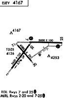
| Runways: | 03/21 08/26 13/31 |
| Longest Runway: | 08/26 is 6100 ft (1859 m) long |
| Runways with an Instrument Approach: |
LWT Airport Runway Details
| Runway 03/21 | 5600 ft x 101 ft (1707 m x 31 m) | |
| Runway Length Source: | NGS as of 10/04/2001 | |
| Surface: | Asphalt - Poor condition - No special surface treatment | |
| Runway Pavement Class: | 14 /F/C/X/T | |
Runway Weight Bearing Capacity (in thousands of pounds) |
||
| Single Wheel Landing Gear: | 12.5 | |
| Dual Wheel Landing Gear: | 80.0 | |
| Dual Tandem Wheel Landing Gear: | 120.0 | |
Runway 03 |
Runway 21 |
|
Elevation: |
4170.4 | 4130.5 |
Latitude: |
47-02-25.3516N | 47-03-08.9233N |
Longitude: |
109-28-51.3807W | 109-28-01.6649W |
|
Runway True Alignment: |
038 | 218 |
Glide Path Angle: |
0.0 degrees | 0.0 degrees |
Traffic Pattern: |
Left | Left |
Runway Markings Type: |
Basic | Basic |
Runway Markings Condition: |
Poor | Poor |
Object at End: |
BLDG | |
Object Height: |
34 | |
Distance from End: |
1620 | |
Object Centerline Offset: |
0 ft. left and right of centerline | |
Declared Distances |
||
Take Off Run Avbl. (TORA): |
5600 | 5600 |
Take Off Distance Avbl. (TODA): |
5600 | 5600 |
Actual Stop Dist. Avbl. (ASDA): |
5600 | 5600 |
Landing Dist. Avbl. (LDA): |
5600 | 5600 |
| Runway 08/26 | 6100 ft x 100 ft (1859 m x 30 m) | |
| Runway Length Source: | NGS as of 10/04/2001 | |
| Surface: | Asphalt - Poor condition - No special surface treatment | |
| Runway Pavement Class: | 18 /F/C/X/T | |
| Runway Edge Lights: | Medium Intensity | |
Runway Weight Bearing Capacity (in thousands of pounds) |
||
| Single Wheel Landing Gear: | 40.0 | |
| Dual Wheel Landing Gear: | 55.0 | |
| Dual Tandem Wheel Landing Gear: | 95.0 | |
Runway 08 |
Runway 26 |
|
Elevation: |
4127.7 | 4111.8 |
Latitude: |
47-03-10.8090N | 47-03-10.7905N |
Longitude: |
109-28-10.4033W | 109-26-42.3276W |
|
Runway True Alignment: |
090 | 270 |
Glide Path Angle: |
3.0 degrees | 3.0 degrees |
Traffic Pattern: |
Left | Left |
Runway Markings Type: |
Precision Instrument | Precision Instrument |
Runway Markings Condition: |
Good | Good |
Object Centerline Offset: |
0 ft. left and right of centerline | |
Visual Glide Slope Indicators: |
2-Light PAPI On Left Side Of Runway | 4-Box VASI On Left Side Of Runway |
REIL: |
Yes | Yes |
Threshold Crossing Height: |
51 | 50 |
Declared Distances |
||
Take Off Run Avbl. (TORA): |
6100 | 6100 |
Take Off Distance Avbl. (TODA): |
6100 | 6100 |
Actual Stop Dist. Avbl. (ASDA): |
6100 | 6100 |
Landing Dist. Avbl. (LDA): |
6100 | 6100 |
| Runway 13/31 | 4102 ft x 62 ft (1250 m x 19 m) | |
| Runway Length Source: | NGS as of 10/04/2001 | |
| Surface: | Asphalt - Poor condition - No special surface treatment | |
| Runway Pavement Class: | 12 /F/C/Y/T | |
| Runway Edge Lights: | Medium Intensity | |
Runway Weight Bearing Capacity (in thousands of pounds) |
||
| Single Wheel Landing Gear: | 12.5 | |
Runway 13 |
Runway 31 |
|
Elevation: |
4131.7 | 4162.6 |
Latitude: |
47-03-06.5593N | 47-02-35.5716N |
Longitude: |
109-28-33.2392W | 109-27-55.1451W |
|
Runway True Alignment: |
140 | 320 |
Glide Path Angle: |
0.0 degrees | 0.0 degrees |
Traffic Pattern: |
Left | Left |
Runway Markings Type: |
Basic | Basic |
Runway Markings Condition: |
Good | Good |
Object Centerline Offset: |
0 ft. left and right of centerline |
Services
Airframe Repair: |
Minor |
Powerplant Repair: |
Minor |
Bottled Oxygen: |
None |
Bulk Oxygen: |
None |
Fuel Available: |
100LL |
Landing Fees: |
No |
Parking: |
Tiedowns available |
Maps & Diagrams
LWT Sectional
Flight Planning
at skyvector.com
at skyvector.com