Location
Latitude: |
43-12-30.2000N (43.208389) |
Longitude: |
095-50-00.3000W (-95.833417) |
Elevation: |
1419.2 feet MSL (433 m MSL) |
Magnetic Variation: |
2 E (as of April 2024 from WMM2020 model) |
Time Zone: |
UTC -6.0 (Standard Time) UTC -5.0 (Daylight Savings Time) |
From City: |
02 N.M. NE of Sheldon, Iowa |
Found On: |
Omaha Chart |
FAA Region: |
ACE |
Contacts
Manager: |
Publicly owned: |
| LYLE VUST 3020 NORTHWEST BOULEVARD SHELDON, IA 51201-7508 712-324-4005 |
CITY OF SHELDON 416 9TH ST BOX 276 SHELDON, IA 51201 712-324-4651 |
Operations
Airport Status: |
Operational |
Facility Use: |
Public |
Type: |
Airport |
Activation Date: |
11/1956 |
Control tower: |
No |
Attendance (Months/Days/Hours): |
Months/Days/Hours ALL/MON - FRI/0730 - 1700 |
Boundary ARTCC: |
ZMP (Minneapolis) |
Responsible ARTCC: |
ZMP (Minneapolis) |
Lighting Schedule: |
SEE RMK |
Segmented Circle Indicator: |
No |
Traffic Pattern Altitude (MSL): |
2419 feet (737 m) |
NOTAMs Facility: |
SHL |
NOTAM-D Service: |
Yes |
International Airport of Entry: |
No |
Customs Landing Rights: |
No |
Military Landing Rights: |
Yes |
Civil/Military Joint Use: |
No |
Based Aircraft
| Single Engine: | 15 |
| Multi Engine: | 4 |
| Jet Engine: | 1 |
Annual Operations (as of 06/21/2023)
| Total Operations: | 5500 | |
| Air Taxi: | 824 | 15.0% |
| GA Local: | 2753 | 50.1% |
| GA Itinerant: | 1888 | 34.3% |
| Military Aircraft: | 35 | 0.6% |
Communications
| CTAF: | 122.800 |
| Unicom: | 122.800 |
| AWOS-3: | 119.775 (712-324-5159) |
- COMMUNICATIONS PRVDD BY FORT DODGE RADIO ON FREQ 122.5 (SPENCER RCO).
- APCH/DEP SVC PRVDD BY MINNEAPOLIS ARTCC (ZMP) ON FREQ 125.025/235.625 (SIOUX CITY RCAG).
Fixed Based Operators (FBOs) & Fuel
(Click on a business for detail)
Please help us keep this information up to date. This is a FREE SERVICE just like everything else on Airport Guide! If you see that a business needs to be added, modified, or deleted please fill out our Update Form.
To add, modify, or delete a business click here.
Please help us keep this information up to date. This is a FREE SERVICE just like everything else on Airport Guide! If you see that a business needs to be added, modified, or deleted please fill out our Update Form.
Area Code: 712 |
| Business Name | Frequency | Phone | Fuel Grade |
|---|---|---|---|
| Midwest Flying Service, Inc.
Update FBO info |
Unicom 122.8 | 324-4005, 324-4507 | 100LL, Jet A |
Flight Service Stations
| Primary | Alternate | |
| FSS on Field: | N | |
| FSS Name (ID): | Fort Dodge(FOD) | |
| Frequency: | ||
| Toll Free Phone: | 1-800-WX-BRIEF |
Instrument Procedures / Charts
FAA Terminal Procedures valid from 0901Z 03/21/24 to 0901Z 04/18/24.
There are various types of charts available for an airport. They are listed in the Page Type column. Here is a legend for those types:
APD - Airport Diagram
DP - Departure Procedure Charts
HOT - Hot Spots
IAP - Instrument Approach Procedure Charts
MIN - Minimums
STAR - Standard Terminal Arrival Charts
| Page Type | Page Name | Volume | Action Since Last Cycle |
|---|---|---|---|
| IAP | RNAV (GPS) RWY 15 | NC-3 | |
| IAP | RNAV (GPS) RWY 33 | NC-3 | |
| MIN | ALTERNATE MINIMUMS | NC-3 | |
| MIN | TAKEOFF MINIMUMS | NC-3 |
Terminal Procedures are only available for airports in several countries with more being added all the time. If you are looking for a specific country's charts, please send an email to support(at)airportguide.com stating the country name. This will be used to prioritize the implementation.
Navigation Aids (Navaids) near KSHL
| Dist (NM) | ID | Morse Code | Name | Type | Freq | True Hdg | Mag Hdg |
|---|---|---|---|---|---|---|---|
| 0.3 | SHL | . . . . . . . . _ . . | Sheldon | NDB | 338 | 356 | 354 |
| 10.2 | ISB | . . . . . _ . . . | Sibley | NDB | 269 | 20 | 18 |
| 16.2 | SOY | . . . _ _ _ _ . _ _ | Sioux Center | NDB | 368 | 253 | 251 |
| 16.5 | ORC | _ _ _ . _ . _ . _ . | Orange City | NDB | 521 | 217 | 215 |
| 22.2 | SP | . . . . _ _ . | Snore | NDB | 394 | 85 | 83 |
| 27.8 | SPW | . . . . _ _ . . _ _ | Spencer | VOR-DME | 115.15 | 95 | 93 |
| 28.5 | OTG | _ _ _ _ _ _ . | Worthington | DME | 110.6 | 22 | 20 |
| 29.3 | OT | _ _ _ _ | Wondd | NDB | 277 | 33 | 31 |
| 31.0 | LTU | . _ . . _ . . _ | Little Sioux | NDB | 326 | 98 | 96 |
| 44.7 | SLB | . . . . _ . . _ . . . | Storm Lake | NDB | 434 | 144 | 142 |
| 45.3 | MJQ | _ _ . _ _ _ _ _ . _ | Jackson | NDB-DME | 353 | 54 | 52 |
| 46.7 | FS | . . _ . . . . | Rokky | NDB | 245 | 291 | 289 |
| 48.6 | PUF | . _ _ . . . _ . . _ . | Puff | NDB | 345 | 79 | 77 |
| 49.0 | EST | . . . . _ | Estherville | VOR | 110.40 | 75 | 73 |
| 49.0 | FSD | . . _ . . . . _ . . | Sioux Falls | VORTAC | 115.00 | 302 | 300 |
| 49.7 | EGQ | . _ _ . _ _ . _ | Emmetsburg | NDB | 410 | 97 | 95 |
| 52.5 | MWM | _ _ . _ _ _ _ | Windom | NDB | 203 | 36 | 34 |
| 52.7 | OI | _ _ _ . . | Tommi | NDB | 305 | 211 | 209 |
| 53.8 | GAK | _ _ . . _ _ . _ | Sioux Gateway | NDB | 233 | 207 | 205 |
| 56.1 | SUX | . . . . . _ _ . . _ | Sioux City | TACAN | 116.50 | 202 | 200 |
Nearby Airports with Fuel
Notices to Airmen (NOTAMS)
Remarks
| A110-1 | RY 33 IS CALM WIND RY. |
| A110-2 | FOR CD CTC MINNEAPOLIS ARTCC AT 651-463-5588. |
| A17 | FOR SERVICE AFTER HRS CALL 712-324-4005 OR 324-1900. |
| A81-APT | ACTVT MIRL RY 15/33; PAPI AND REIL RYS 15 & 33 - CTAF. |
Runways
Runway Summary
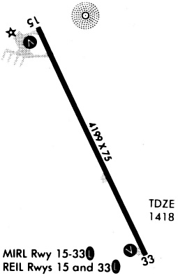
| Runways: | 15/33 |
| Longest Runway: | 15/33 is 4199 ft (1280 m) long |
| Runways with an Instrument Approach: |
KSHL Airport Runway Details
| Runway 15/33 | 4199 ft x 75 ft (1280 m x 23 m) | |
| Runway Length Source: | 3RD PARTY SURVEY as of 03/10/2011 | |
| Surface: | Concrete - Fair condition - No special surface treatment | |
| Runway Pavement Class: | 7 /R/C/W/U | |
| Runway Edge Lights: | Medium Intensity | |
Runway Weight Bearing Capacity (in thousands of pounds) |
||
| Single Wheel Landing Gear: | 28.0 | |
Runway 15 |
Runway 33 |
|
Elevation: |
1419.2 | 1412.6 |
Latitude: |
43-12-49.0532N | 43-12-11.3352N |
Longitude: |
095-50-12.1167W | 095-49-48.5446W |
|
Runway True Alignment: |
155 | 335 |
Glide Path Angle: |
3.0 degrees | 3.0 degrees |
Traffic Pattern: |
Left | Left |
Runway Markings Type: |
Nonprecision Instrument | Nonprecision Instrument |
Runway Markings Condition: |
Fair | Fair |
Object at End: |
ROAD | TREES |
Object Height: |
15 | 38 |
Distance from End: |
500 | 1490 |
Object Centerline Offset: |
165 ft. left of centerline | 400 ft. right of centerline |
Visual Glide Slope Indicators: |
2-Light PAPI On Left Side Of Runway | 2-Light PAPI On Left Side Of Runway |
REIL: |
Yes | Yes |
Threshold Crossing Height: |
40 | 40 |
Services
Airframe Repair: |
None |
Powerplant Repair: |
None |
Bottled Oxygen: |
None |
Bulk Oxygen: |
None |
Fuel Available: |
100LL, Jet A |
Landing Fees: |
No |
Parking: |
Hangars and tiedowns available |
Maps & Diagrams
KSHL Sectional
Flight Planning
at skyvector.com
at skyvector.com