Location
Latitude: |
31-29-05.7000N (31.484917) |
Longitude: |
097-18-59.5000W (-97.316528) |
Elevation: |
591.7 feet MSL (180 m MSL) |
Magnetic Variation: |
3 E (as of April 2024 from WMM2020 model) |
Time Zone: |
UTC -6.0 (Standard Time) UTC -5.0 (Daylight Savings Time) |
From City: |
04 N.M. W of Waco, Texas |
Found On: |
San Antonio Chart |
FAA Region: |
ASW |
Contacts
Manager: |
Publicly owned: |
| BARRY LIGHTFOOT PO BOX 192 MC GREGOR, TX 76657 254-848-5477 |
CITY OF MCGREGOR P O BOX 192 MC GREGOR, TX 76657 254-840-2806 |
Operations
Airport Status: |
Operational |
Facility Use: |
Public |
Type: |
Airport |
Activation Date: |
01/1940 |
Control tower: |
No |
Attendance (Months/Days/Hours): |
Months/Days/Hours ALL/ALL/0700-1900 |
Boundary ARTCC: |
ZFW (Fort Worth) |
Responsible ARTCC: |
ZFW (Fort Worth) |
Lighting Schedule: |
SEE RMK |
Segmented Circle Indicator: |
Yes |
Traffic Pattern Altitude (MSL): |
1592 feet (485 m) |
NOTAMs Facility: |
PWG |
NOTAM-D Service: |
Yes |
International Airport of Entry: |
No |
Customs Landing Rights: |
No |
Military Landing Rights: |
Yes |
Civil/Military Joint Use: |
No |
Based Aircraft
| Single Engine: | 68 |
| Multi Engine: | 11 |
| Jet Engine: | 8 |
| GA Helicopters: | 2 |
Annual Operations (as of 12/31/2018)
| Total Operations: | 36600 | |
| Air Taxi: | 500 | 1.4% |
| GA Local: | 27000 | 73.8% |
| GA Itinerant: | 9000 | 24.6% |
| Military Aircraft: | 100 | 0.3% |
Communications
| CTAF: | 122.800 |
| Unicom: | 122.800 |
| Approach: | WACO FORT WORTH ARTCC |
| Departure: | WACO FORT WORTH ARTCC |
| AWOS-3PT: | 135.525 (254-848-4581) |
- APCH/DEP CTL SVC PRVDD BY FORT WORTH ARTCC (ZFW) ON FREQS 133.3/269.5 (WACO RCAG) WHEN WACO APCH CTL (ACT) CLSD.
Fixed Based Operators (FBOs) & Fuel
(Click on a business for detail)
Please help us keep this information up to date. This is a FREE SERVICE just like everything else on Airport Guide! If you see that a business needs to be added, modified, or deleted please fill out our Update Form.
To add, modify, or delete a business click here.
Please help us keep this information up to date. This is a FREE SERVICE just like everything else on Airport Guide! If you see that a business needs to be added, modified, or deleted please fill out our Update Form.
Area Code: 254 |
| Business Name | Frequency | Phone | Fuel Grade |
|---|---|---|---|
| Aurora Aviation, Inc
Website Update FBO info |
122.8 | (254) 848-2345 | 100LL, Jet A |

|
Phillips | 100LL - 2.35 USD per gallon on 1/21/02 |
Pumps Or Trucks |
|
|
Phillips | Jet A - 2.20 USD per gallon on 1/21/02 |
Pumps Or Trucks |
| Brazos Air
Update FBO info |
Unicom 122.8 | 848-4448 | 100LL, Jet A |
| McGregor Airport Texaco Travel Center
Update FBO info |
848-2022 |
Flight Service Stations
| Primary | Alternate | |
| FSS on Field: | N | |
| FSS Name (ID): | Fort Worth(FTW) | |
| Frequency: | ||
| Toll Free Phone: | 1-800-WX-BRIEF |
Instrument Procedures / Charts
FAA Terminal Procedures valid from 0901Z 03/21/24 to 0901Z 04/18/24.
There are various types of charts available for an airport. They are listed in the Page Type column. Here is a legend for those types:
APD - Airport Diagram
DP - Departure Procedure Charts
HOT - Hot Spots
IAP - Instrument Approach Procedure Charts
MIN - Minimums
STAR - Standard Terminal Arrival Charts
| Page Type | Page Name | Volume | Action Since Last Cycle |
|---|---|---|---|
| IAP | RNAV (GPS) RWY 17 | SC-3 | |
| IAP | RNAV (GPS) RWY 35 | SC-3 | |
| IAP | VOR RWY 17 | SC-3 | |
| MIN | ALTERNATE MINIMUMS | SC-3 | |
| MIN | RADAR MINIMUMS | SC-3 | |
| MIN | TAKEOFF MINIMUMS | SC-3 |
Terminal Procedures are only available for airports in several countries with more being added all the time. If you are looking for a specific country's charts, please send an email to support(at)airportguide.com stating the country name. This will be used to prioritize the implementation.
Navigation Aids (Navaids) near KPWG
| Dist (NM) | ID | Morse Code | Name | Type | Freq | True Hdg | Mag Hdg |
|---|---|---|---|---|---|---|---|
| 10.9 | ACT | . _ _ . _ . _ | Waco | VORTAC | 115.30 | 12 | 9 |
| 12.7 | ROB | . _ . _ _ _ _ . . . | Robinson | NDB | 400 | 84 | 81 |
| 17.4 | TPL | _ . _ _ . . _ . . | Temple | DME | 110.4 | 198 | 195 |
| 29.4 | HLR | . . . . . _ . . . _ . | Hood | NDB | 347 | 223 | 220 |
| 34.2 | IL | . . . _ . . | Iresh | NDB | 278 | 216 | 213 |
| 34.5 | GR | _ _ . . _ . | Starn | NDB | 323 | 236 | 233 |
| 37.2 | GRK | _ _ . . _ . _ . _ | Gray | VOR-DME | 111.80 | 223 | 220 |
| 39.7 | GNL | _ _ . _ . . _ . . | Groesbeck | DME | 108.8 | 81 | 78 |
| 42.1 | LXY | . _ . . _ . . _ _ . _ _ | Mexia | NDB | 329 | 77 | 74 |
| 43.3 | MNZ | _ _ _ . _ _ . . | Hamilton | NDB | 251 | 281 | 278 |
| 46.0 | AGJ | . _ _ _ . . _ _ _ | Gooch Springs | VORTAC | 112.50 | 247 | 244 |
| 49.6 | JEN | . _ _ _ . _ . | Glen Rose | TACAN | 115.00 | 324 | 321 |
| 51.5 | GUO | _ _ . . . _ _ _ _ | Georgetown | NDB | 332 | 201 | 198 |
| 57.2 | CGQ | _ . _ . _ _ . _ _ . _ | Powell | NDB | 344 | 52 | 49 |
| 57.2 | CRS | _ . _ . . _ . . . . | Corsicana | NDB | 396 | 55 | 52 |
| 61.5 | PYF | . _ _ . _ . _ _ . . _ . | Pyramid | NDB | 418 | 68 | 65 |
| 65.0 | BMQ | _ . . . _ _ _ _ . _ | Burnet | NDB | 341 | 226 | 223 |
| 67.3 | CWK | _ . _ . . _ _ _ . _ | Centex | VORTAC | 112.80 | 189 | 186 |
| 70.0 | CQY | _ . _ . _ _ . _ _ . _ _ | Cedar Creek | VORTAC | 114.80 | 52 | 49 |
| 70.1 | CLL | _ . _ . . _ . . . _ . . | College Station | VORTAC | 113.30 | 138 | 135 |
Nearby Airports with Fuel
Notices to Airmen (NOTAMS)
Remarks
| A110*G | THIS AIRPORT HAS BEEN SURVEYED BY THE NATIONAL GEODETIC SURVEY. |
| A110-1 | GCO AVBL ON FREQ 121.725 THRU ACT CD & FLT SVCS. |
| A110-2 | CALM WIND LESS THAN 5 KNOTS USE RWY 17. |
| A110-3 | 2550 FT MSL TWRS, 8 MILES SOUTH RWY 35 END. |
| A110-4 | FOR CD IF UNA VIA GCO CTC FORT WORTH ARTCC AT 817-858-7584. |
| A16 | OR 254-848-2345. (FBO) 254-840-2855 (POLICE) |
| A70-FUEL-10 | 0LL AFT HRS FUEL CALL 254-379-8204. MILITARY FUEL CONTRACT. |
| A81-APT | ACTVT REIL RWY 17 - CTAF. MIRL RWY 17/35 PRESET LOW INTST; TO INCR INTST ACTVT - CTAF. |
Runways
Runway Summary
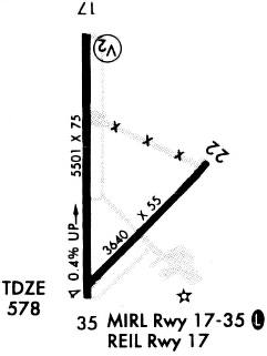
| Runways: | 04/22 17/35 |
| Longest Runway: | 17/35 is 5501 ft (1677 m) long |
| Runways with an Instrument Approach: |
KPWG Airport Runway Details
| Runway 04/22 | 3484 ft x 55 ft (1062 m x 17 m) | |
| Runway Length Source: | NGS as of 10/09/1995 | |
| Surface: | Asphalt - Good condition - No special surface treatment | |
Runway Weight Bearing Capacity (in thousands of pounds) |
||
| Single Wheel Landing Gear: | 12.0 | |
Runway 04 |
Runway 22 |
|
Elevation: |
567.6 | 568.0 |
Latitude: |
31-28-45.8140N | 31-29-10.6480N |
Longitude: |
097-19-03.9900W | 097-18-36.0770W |
|
Runway True Alignment: |
044 | 224 |
Glide Path Angle: |
0.0 degrees | 0.0 degrees |
Traffic Pattern: |
Left | Left |
Runway Markings Type: |
Basic | Basic |
Runway Markings Condition: |
Good | Good |
Object at End: |
TREES | |
Object Height: |
74 | |
Distance from End: |
2690 | |
Object Centerline Offset: |
0 ft. left and right of centerline |
| Runway 17/35 | 5501 ft x 75 ft (1677 m x 23 m) | |
| Runway Length Source: | NGS as of 10/09/1995 | |
| Surface: | Asphalt - Good condition - No special surface treatment | |
| Runway Edge Lights: | Medium Intensity | |
Runway Weight Bearing Capacity (in thousands of pounds) |
||
| Single Wheel Landing Gear: | 30.0 | |
| Dual Wheel Landing Gear: | 50.0 | |
Runway 17 |
Runway 35 |
|
Elevation: |
590.5 | 566.0 |
Latitude: |
31-29-37.6540N | 31-28-43.2210N |
Longitude: |
097-19-06.0290W | 097-19-04.9200W |
|
Runway True Alignment: |
179 | 359 |
Glide Path Angle: |
3.0 degrees | 3.0 degrees |
Traffic Pattern: |
Left | Left |
Runway Markings Type: |
Nonprecision Instrument | Nonprecision Instrument |
Runway Markings Condition: |
Good | Good |
Object at End: |
TREES | TREES |
Object Height: |
32 | 39 |
Distance from End: |
1112 | 1200 |
Object Centerline Offset: |
0 ft. left and right of centerline | |
Visual Glide Slope Indicators: |
4-Light PAPI On Left Side Of Runway | 4-Light PAPI On Left Side Of Runway |
REIL: |
Yes | |
Threshold Crossing Height: |
36 | 46 |
Services
Fuel Available: |
100LL, Jet A |
Parking: |
Hangars and tiedowns available |
Maps & Diagrams
KPWG Sectional
Flight Planning
at skyvector.com
at skyvector.com