Location
Latitude: |
40-09-07.0000N (40.151944) |
Longitude: |
097-35-04.3000W (-97.584528) |
Elevation: |
1468.2 feet MSL (448 m MSL) |
Magnetic Variation: |
3.2 E (as of April 2024 from WMM2020 model) |
Time Zone: |
UTC -6.0 (Standard Time) UTC -5.0 (Daylight Savings Time) |
From City: |
01 N.M. S of Hebron, Nebraska |
Found On: |
Omaha Chart |
FAA Region: |
ACE |
Contacts
Manager: |
Publicly owned: |
| WILLIAM LINTON 1115 OLIVE AVE HEBRON, NE 68370-1317 (402) 768-6597 |
HEBRON ARPT AUTHORITY P.O. BOX 256 HEBRON, NE 68370-0256 (402) 768-6597 |
Operations
Airport Status: |
Operational |
Facility Use: |
Public |
Type: |
Airport |
Activation Date: |
03/1941 |
Control tower: |
No |
Attendance (Months/Days/Hours): |
Months/Days/Hours Unattended |
Boundary ARTCC: |
ZMP (Minneapolis) |
Responsible ARTCC: |
ZMP (Minneapolis) |
Lighting Schedule: |
SEE RMK |
Segmented Circle Indicator: |
Yes |
Traffic Pattern Altitude (MSL): |
2468 feet (752 m) |
NOTAMs Facility: |
HJH |
NOTAM-D Service: |
Yes |
International Airport of Entry: |
No |
Customs Landing Rights: |
No |
Military Landing Rights: |
No |
Civil/Military Joint Use: |
No |
Based Aircraft
| Single Engine: | 7 |
| Multi Engine: | 1 |
| GA Helicopters: | 2 |
Annual Operations (as of 05/06/2021)
| Total Operations: | 5500 | |
| GA Local: | 4880 | 88.7% |
| GA Itinerant: | 540 | 9.8% |
| Military Aircraft: | 80 | 1.5% |
Communications
| CTAF: | 122.900 |
| AWOS-3: | 118.525 (402-768-2501) |
- APCH/DEP SVC PRVDD BY MINNEAPOLIS ARTCC ON FREQS 126.4/317.7 (MARYSVILLE RCAG).
Fixed Based Operators (FBOs) & Fuel
(Click on a business for detail)
Please help us keep this information up to date. This is a FREE SERVICE just like everything else on Airport Guide! If you see that a business needs to be added, modified, or deleted please fill out our Update Form.
To add, modify, or delete a business click here.
Please help us keep this information up to date. This is a FREE SERVICE just like everything else on Airport Guide! If you see that a business needs to be added, modified, or deleted please fill out our Update Form.
Area Code: 402 |
| Business Name | Frequency | Phone | Fuel Grade |
|---|
Flight Service Stations
| Primary | Alternate | |
| FSS on Field: | N | |
| FSS Name (ID): | Columbus(OLU) | |
| Frequency: | ||
| Toll Free Phone: | 1-800-WX-BRIEF |
Instrument Procedures / Charts
FAA Terminal Procedures valid from 0901Z 03/21/24 to 0901Z 04/18/24.
There are various types of charts available for an airport. They are listed in the Page Type column. Here is a legend for those types:
APD - Airport Diagram
DP - Departure Procedure Charts
HOT - Hot Spots
IAP - Instrument Approach Procedure Charts
MIN - Minimums
STAR - Standard Terminal Arrival Charts
| Page Type | Page Name | Volume | Action Since Last Cycle |
|---|---|---|---|
| IAP | GPS RWY 30 | NC-2 | |
| IAP | RNAV (GPS) RWY 12 | NC-2 | |
| MIN | ALTERNATE MINIMUMS | NC-2 | |
| MIN | TAKEOFF MINIMUMS | NC-2 |
Terminal Procedures are only available for airports in several countries with more being added all the time. If you are looking for a specific country's charts, please send an email to support(at)airportguide.com stating the country name. This will be used to prioritize the implementation.
Navigation Aids (Navaids) near KHJH
| Dist (NM) | ID | Morse Code | Name | Type | Freq | True Hdg | Mag Hdg |
|---|---|---|---|---|---|---|---|
| 0.2 | HJH | . . . . . _ _ _ . . . . | Hebron | NDB | 323 | 238 | 235 |
| 19.3 | FBY | . . _ . _ . . . _ . _ _ | Fairbury | NDB | 293 | 85 | 82 |
| 20.6 | RPB | . _ . . _ _ . _ . . . | Republican | NDB | 414 | 189 | 186 |
| 26.3 | FMZ | . . _ . _ _ _ _ . . | Beklof | NDB | 392 | 1 | 358 |
| 36.0 | CNK | _ . _ . _ . _ . _ | Concordia | NDB | 335 | 184 | 181 |
| 37.3 | TKO | _ _ . _ _ _ _ | Mankato | VORTAC | 109.80 | 236 | 233 |
| 39.1 | BIE | _ . . . . . . | Beatrice | VOR | 110.60 | 76 | 73 |
| 44.8 | JYR | . _ _ _ _ . _ _ . _ . | York | NDB | 257 | 358 | 355 |
| 47.2 | HSI | . . . . . . . . . | Hastings | VOR-DME | 108.80 | 305 | 302 |
| 47.7 | SWT | . . . . _ _ _ | Seward | NDB | 269 | 26 | 23 |
| 50.2 | CYW | _ . _ . _ . _ _ . _ _ | Clay Center | NDB | 362 | 156 | 153 |
| 51.8 | LN | . _ . . _ . | Potts | NDB | 385 | 46 | 43 |
| 51.9 | PSS | . _ _ . . . . . . . | Prosser | NDB | 338 | 308 | 304 |
| 54.6 | GR | _ _ . . _ . | Sancy | NDB | 380 | 322 | 319 |
| 60.0 | GRI | _ _ . . _ . . . | Grand Island | VOR-DME | 112.00 | 326 | 323 |
| 60.2 | LNK | . _ . . _ . _ . _ | Lincoln | VORTAC | 116.10 | 39 | 36 |
| 63.2 | PWE | . _ _ . . _ _ . | Pawnee City | DME | 112.4 | 86 | 83 |
| 71.7 | EA | . . _ | Anoke | NDB | 422 | 293 | 289 |
| 73.4 | EAR | . . _ . _ . | Kearney | VOR | 111.20 | 298 | 294 |
| 73.6 | SLN | . . . . _ . . _ . | Salina | VORTAC | 117.10 | 181 | 178 |
Nearby Airports with Fuel
Notices to Airmen (NOTAMS)
Remarks
| A110*G | THIS AIRPORT HAS BEEN SURVEYED BY THE NATIONAL GEODETIC SURVEY. |
| A110-1 | APCHS PROTECTED BY STRUCTURE CONTROL ORDINANCE. |
| A110-2 | FOR CD CTC MINNEAPOLIS ARTCC AT 651-463-5588. |
| A42-03 | RY 03/21 MKD WITH REFLECTORS & YELLOW CONES. |
| A54-03 | RWY 21 8 FT TALL CORN IN SUMMER CAN CREATE 22:1. |
| A70-FUEL-10 | 0LL 24-HR CREDIT CARD READER FOR FUEL. IF UNAVABL CALL (402) 768-6597. |
| A71 | AIRFRAME RPRS BY APNTMT ONLY. |
| A72 | PWR PLANT RPRS BY APNTMT ONLY. |
| A81-APT | ACTVT MIRL RY 12/30; PAPI & REIL RYS 12 & 30 - CTAF. |
Runways
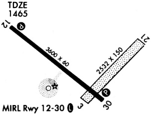
Runway Summary
| Runways: | 03/21 12/30 |
| Longest Runway: | 12/30 is 3600 ft (1097 m) long |
| Runways with an Instrument Approach: |
KHJH Airport Runway Details
| Runway 03/21 | 2513 ft x 150 ft (766 m x 46 m) | |
| Runway Length Source: | 3RD PARTY SURVEY as of 12/07/2011 | |
| Surface: | Turf - Fair condition - No special surface treatment | |
Runway 03 |
Runway 21 |
|
Elevation: |
1468.2 | 1451.8 |
Latitude: |
40-08-56.2314N | 40-09-14.7520N |
Longitude: |
097-35-02.3551W | 097-34-40.8044W |
|
Runway True Alignment: |
042 | 222 |
Glide Path Angle: |
0.0 degrees | 0.0 degrees |
Traffic Pattern: |
Left | Left |
Object at End: |
TREES | ROAD |
Object Height: |
54 | 15 |
Distance from End: |
1085 | 567 |
Object Centerline Offset: |
222 ft. right of centerline | 0 ft. left and right of centerline |
| Runway 12/30 | 3600 ft x 60 ft (1097 m x 18 m) | |
| Runway Length Source: | 3RD PARTY SURVEY as of 12/07/2011 | |
| Surface: | Turf - Fair condition - No special surface treatment | |
| Runway Edge Lights: | Medium Intensity | |
Runway Weight Bearing Capacity (in thousands of pounds) |
||
| Single Wheel Landing Gear: | 30.0 | |
Runway 12 |
Runway 30 |
|
Elevation: |
1462.2 | 1465.6 |
Latitude: |
40-09-19.1814N | 40-08-57.0820N |
Longitude: |
097-35-31.2895W | 097-34-54.9570W |
|
Runway True Alignment: |
128 | 308 |
Glide Path Angle: |
3.9 degrees | 3.0 degrees |
Traffic Pattern: |
Left | Left |
Runway Markings Type: |
Nonprecision Instrument | Nonprecision Instrument |
Runway Markings Condition: |
Good | Good |
Object at End: |
TREE | ROAD |
Object Height: |
61 | 27 |
Distance from End: |
1428 | 743 |
Object Centerline Offset: |
222 ft. right of centerline | 0 ft. left and right of centerline |
Visual Glide Slope Indicators: |
2-Light PAPI On Left Side Of Runway | 2-Light PAPI On Left Side Of Runway |
REIL: |
Yes | Yes |
Threshold Crossing Height: |
52 | 40 |
Services
Airframe Repair: |
Major |
Powerplant Repair: |
Major |
Bottled Oxygen: |
None |
Bulk Oxygen: |
None |
Fuel Available: |
100LL, Jet A |
Landing Fees: |
No |
Parking: |
Hangars and tiedowns available |
Maps & Diagrams
KHJH Sectional
Flight Planning
at skyvector.com
at skyvector.com