Location
Latitude: |
37-48-28.2000N (37.807833) |
Longitude: |
087-41-08.5000W (-87.685694) |
Elevation: |
386.7 feet MSL (118 m MSL) |
Magnetic Variation: |
3.7 W (as of April 2024 from WMM2020 model) |
Time Zone: |
UTC -6.0 (Standard Time) UTC -5.0 (Daylight Savings Time) |
From City: |
04 N.M. W of Henderson, Kentucky |
Found On: |
St Louis Chart |
FAA Region: |
ASO |
Contacts
Manager: |
Publicly owned: |
| ALLEN BENNETT 2154 HWY 136 W. HENDERSON, KY 42420 270-860-6901 |
HENDERSON CITY-COUNTY AIRPORT BOARD 2154 HWY 136W SUITE 1 HENDERSON, KY 42420 (270) 860-6901 |
Operations
Airport Status: |
Operational |
Facility Use: |
Public |
Type: |
Airport |
Activation Date: |
10/1946 |
Control tower: |
No |
Attendance (Months/Days/Hours): |
Months/Days/Hours ALL/MON-FRI/0700-DUSK |
Boundary ARTCC: |
ZID (Indianapolis) |
Responsible ARTCC: |
ZID (Indianapolis) |
Lighting Schedule: |
SEE RMK |
Segmented Circle Indicator: |
Yes |
Traffic Pattern Altitude (MSL): |
1387 feet (423 m) |
NOTAMs Facility: |
EHR |
NOTAM-D Service: |
Yes |
International Airport of Entry: |
No |
Customs Landing Rights: |
No |
Military Landing Rights: |
Yes |
Civil/Military Joint Use: |
No |
Based Aircraft
| Single Engine: | 15 |
| Multi Engine: | 2 |
| Jet Engine: | 1 |
Annual Operations (as of 11/06/2019)
| Total Operations: | 33000 | |
| Air Taxi: | 2831 | 8.6% |
| GA Local: | 14658 | 44.4% |
| GA Itinerant: | 15391 | 46.6% |
| Military Aircraft: | 120 | 0.4% |
Communications
| CTAF: | 122.800 |
| Unicom: | 122.800 |
| Approach: | EVANSVILLE 124.025 124.025 INDIANAPOLIS ARTCC |
| Departure: | EVANSVILLE 124.025 124.025 INDIANAPOLIS ARTCC |
| AWOS-3PT: | 118.85 (270-826-0511) |
- APCH/DEP SVC PRVDD BY INDIANAPOLIS ARTCC (ZID) ON FREQS 128.3/291.625 (EVANSVILLE RCAG) WHEN EVANSVILLE APCH CTL CLSD.
Fixed Based Operators (FBOs) & Fuel
(Click on a business for detail)
Please help us keep this information up to date. This is a FREE SERVICE just like everything else on Airport Guide! If you see that a business needs to be added, modified, or deleted please fill out our Update Form.
To add, modify, or delete a business click here.
Please help us keep this information up to date. This is a FREE SERVICE just like everything else on Airport Guide! If you see that a business needs to be added, modified, or deleted please fill out our Update Form.
Area Code: 270 |
| Business Name | Frequency | Phone | Fuel Grade |
|---|---|---|---|
| Bell Helicopter Service Center
Update FBO info |
826-6000 | 100LL, Jet A | |
| Don Davis Aviation, Inc.
Update FBO info |
Unicom 122.8 | 826-6000 | 100LL, Jet A |
Flight Service Stations
| Primary | Alternate | |
| FSS on Field: | N | |
| FSS Name (ID): | Louisville(LOU) | |
| Frequency: | ||
| Toll Free Phone: | 1-800-WX-BRIEF |
Instrument Procedures / Charts
FAA Terminal Procedures valid from 0901Z 03/21/24 to 0901Z 04/18/24.
There are various types of charts available for an airport. They are listed in the Page Type column. Here is a legend for those types:
APD - Airport Diagram
DP - Departure Procedure Charts
HOT - Hot Spots
IAP - Instrument Approach Procedure Charts
MIN - Minimums
STAR - Standard Terminal Arrival Charts
| Page Type | Page Name | Volume | Action Since Last Cycle |
|---|---|---|---|
| IAP | RNAV (GPS) RWY 09 | SE-1 | |
| IAP | RNAV (GPS) RWY 27 | SE-1 | |
| IAP | VOR-A | SE-1 | |
| MIN | ALTERNATE MINIMUMS | SE-1 | |
| MIN | TAKEOFF MINIMUMS | SE-1 |
Terminal Procedures are only available for airports in several countries with more being added all the time. If you are looking for a specific country's charts, please send an email to support(at)airportguide.com stating the country name. This will be used to prioritize the implementation.
Navigation Aids (Navaids) near KEHR
| Dist (NM) | ID | Morse Code | Name | Type | Freq | True Hdg | Mag Hdg |
|---|---|---|---|---|---|---|---|
| 8.1 | PXV | . _ _ . _ . . _ . . . _ | Pocket City | VORTAC | 113.30 | 333 | 337 |
| 15.7 | PDW | . _ _ . _ . . . _ _ | Evansville | NDB | 284 | 27 | 31 |
| 25.0 | OWB | _ _ _ . _ _ _ . . . | Owensboro | VOR-DME | 108.60 | 98 | 102 |
| 26.9 | OW | _ _ _ . _ _ | Higuy | NDB | 341 | 112 | 116 |
| 32.5 | CCT | _ . _ . _ . _ . _ | Central City | DME | 109.8 | 141 | 145 |
| 40.7 | HSB | . . . . . . . _ . . . | Harrisburg-Raleigh | NDB | 230 | 270 | 273 |
| 42.9 | GMH | _ _ . _ _ . . . . | Muhlenberg | NDB | 362 | 144 | 148 |
| 43.5 | HNB | . . . . _ . _ . . . | Huntingburg | VOR-DME | 109.20 | 52 | 56 |
| 44.8 | SAM | . . . . _ _ _ | Samsville | DME | 116.6 | 335 | 339 |
| 48.4 | FWC | . . _ . . _ _ _ . _ . | Wayne County | NDB | 257 | 315 | 318 |
| 48.7 | TEL | _ . . _ . . | Tell City | NDB | 206 | 74 | 78 |
| 53.3 | OEA | _ _ _ . . _ | Vincennes | NDB | 251 | 6 | 10 |
| 57.9 | LWV | . _ . . . _ _ . . . _ | Lawrenceville | DME | 108.8 | 3 | 7 |
| 58.1 | HIX | . . . . . . _ . . _ | Honey Grove | NDB | 356 | 163 | 167 |
| 59.2 | OLY | _ _ _ . _ . . _ . _ _ | Olney | NDB | 272 | 337 | 341 |
| 60.9 | MW | _ _ . _ _ | Jonny | NDB | 382 | 272 | 275 |
| 61.5 | BDD | _ . . . _ . . _ . . | Bellgrade | NDB | 254 | 230 | 233 |
| 62.5 | VNN | . . . _ _ . _ . | Mount Vernon | DME | 113.8 | 302 | 305 |
| 63.0 | MWA | _ _ . _ _ . _ | Marion | DME | 110.4 | 267 | 270 |
| 65.5 | FK | . . _ . _ . _ | Airbe | NDB | 273 | 168 | 172 |
Nearby Airports with Fuel
Notices to Airmen (NOTAMS)
Remarks
| A11 | AIRPORT CHAIRMAN- DR. RICHARD WHAM. |
| A110*G | THIS AIRPORT HAS BEEN SURVEYED BY THE NATIONAL GEODETIC SURVEY. |
| A110-1 | FOR CD CTC EVANSVILLE APCH AT 812-436-4690, WHEN APCH CLSD CTC INDIANAPOLIS ARTCC AT 317-247-2411. |
| A16 | ADDL PHONE 270-577-1444 |
| A70-FUEL-10 | 0LL FOR SVC AFTER HRS CALL 270-826-6000. |
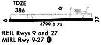
| A81-APT | MIRL RY 09/27 PRESET LOW INTST; TO INCR INTST & ACTVT REIL RY 09/27; PAPI RY 09/ 27; MIRL RY 9/27- CTAF. |
| E111 | EXISTED PRIOR TO 1959. |
Runways
Runway Summary
| Runways: | 09/27 |
| Longest Runway: | 09/27 is 5503 ft (1677 m) long |
| Runways with an Instrument Approach: |
KEHR Airport Runway Details
| Runway 09/27 | 5503 ft x 100 ft (1677 m x 30 m) | |
| Runway Length Source: | 3RD PARTY SURVEY as of 03/04/2016 | |
| Surface: | Asphalt - Good condition - No special surface treatment | |
| Runway Pavement Class: | 13 /F/D/X/T | |
| Runway Edge Lights: | Medium Intensity | |
Runway Weight Bearing Capacity (in thousands of pounds) |
||
| Single Wheel Landing Gear: | 34.5 | |
| Dual Wheel Landing Gear: | 46.0 | |
| Dual Tandem Wheel Landing Gear: | 130.0 | |
Runway 09 |
Runway 27 |
|
Elevation: |
384.2 | 386.1 |
Latitude: |
37-48-27.4355N | 37-48-28.9957N |
Longitude: |
087-41-42.7516W | 087-40-34.2095W |
|
Runway True Alignment: |
088 | 268 |
Glide Path Angle: |
3.0 degrees | 3.0 degrees |
Traffic Pattern: |
Left | Left |
Runway Markings Type: |
Nonprecision Instrument | Nonprecision Instrument |
Runway Markings Condition: |
Fair | Fair |
Object at End: |
ROAD | |
Object Height: |
16 | |
Distance from End: |
596 | |
Object Centerline Offset: |
312 ft. right of centerline | |
Visual Glide Slope Indicators: |
4-Light PAPI On Left Side Of Runway | 4-Light PAPI On Left Side Of Runway |
REIL: |
Yes | Yes |
Threshold Crossing Height: |
43 | 30 |
Services
Fuel Available: |
100LL, Jet A |
Landing Fees: |
No |
Parking: |
Tiedowns available |
Maps & Diagrams
KEHR Sectional
Flight Planning
at skyvector.com
at skyvector.com