Location
Latitude: |
38-33-16.0590N (38.554461) |
Longitude: |
082-44-15.5830W (-82.737662) |
Elevation: |
546.7 feet MSL (167 m MSL) |
Magnetic Variation: |
7.2 W (as of April 2024 from WMM2020 model) |
Time Zone: |
UTC -5.0 (Standard Time) UTC -4.0 (Daylight Savings Time) |
From City: |
06 N.M. NW of Ashland, Kentucky |
Found On: |
Cincinnati Chart |
FAA Region: |
ASO |
Contacts
Manager: |
Publicly owned: |
| JOHN STINES 501 SCOTT ST WORTHINGTON, KY 41183 (606) 858-2849 |
ASHLAND REGIONAL AIRPORT BOARD 501 SCOTT ST WORTHINGTON, KY 41183 (606) 232-1469 |
Operations
Airport Status: |
Operational |
Facility Use: |
Public |
Type: |
Airport |
Activation Date: |
10/1948 |
Control tower: |
No |
Attendance (Months/Days/Hours): |
Months/Days/Hours ALL/ALL/0800-1800 |
Boundary ARTCC: |
ZID (Indianapolis) |
Responsible ARTCC: |
ZID (Indianapolis) |
Lighting Schedule: |
SEE RMK |
Segmented Circle Indicator: |
Yes |
Traffic Pattern Altitude (MSL): |
1547 feet (472 m) |
NOTAMs Facility: |
LOU |
NOTAM-D Service: |
Yes |
International Airport of Entry: |
No |
Customs Landing Rights: |
No |
Military Landing Rights: |
Yes |
Civil/Military Joint Use: |
No |
Based Aircraft
| Single Engine: | 23 |
| Multi Engine: | 1 |
| Jet Engine: | 2 |
Annual Operations (as of 07/13/2022)
| Total Operations: | 7590 | |
| Air Taxi: | 550 | 7.2% |
| GA Local: | 3795 | 50.0% |
| GA Itinerant: | 2970 | 39.1% |
| Military Aircraft: | 275 | 3.6% |
Communications
| CTAF: | 122.800 |
| Unicom: | 122.800 |
| Clearance Del.: | 121.7 121.7 121.7 |
| Approach: | HUNTINGTON |
| Departure: | HUNTINGTON |
| AWOS-3PT: | 132.425 (606-836-2682) |
Fixed Based Operators (FBOs) & Fuel
(Click on a business for detail)
Please help us keep this information up to date. This is a FREE SERVICE just like everything else on Airport Guide! If you see that a business needs to be added, modified, or deleted please fill out our Update Form.
To add, modify, or delete a business click here.
Please help us keep this information up to date. This is a FREE SERVICE just like everything else on Airport Guide! If you see that a business needs to be added, modified, or deleted please fill out our Update Form.
Area Code: 606 |
| Business Name | Frequency | Phone | Fuel Grade |
|---|---|---|---|
| Chasteen Aviation
Update FBO info |
Unicom 122.8 | 836-1162 | 100LL, Jet A |
Flight Service Stations
| Primary | Alternate | |
| FSS on Field: | N | |
| FSS Name (ID): | Louisville(LOU) | |
| Frequency: | ||
| Toll Free Phone: | 1-800-WX-BRIEF |
Instrument Procedures / Charts
FAA Terminal Procedures valid from 0901Z 03/21/24 to 0901Z 04/18/24.
There are various types of charts available for an airport. They are listed in the Page Type column. Here is a legend for those types:
APD - Airport Diagram
DP - Departure Procedure Charts
HOT - Hot Spots
IAP - Instrument Approach Procedure Charts
MIN - Minimums
STAR - Standard Terminal Arrival Charts
| Page Type | Page Name | Volume | Action Since Last Cycle |
|---|---|---|---|
| IAP | RNAV (GPS) RWY 10 | SE-1 | |
| IAP | RNAV (GPS) RWY 28 | SE-1 | |
| MIN | ALTERNATE MINIMUMS | SE-1 | |
| MIN | TAKEOFF MINIMUMS | SE-1 |
Terminal Procedures are only available for airports in several countries with more being added all the time. If you are looking for a specific country's charts, please send an email to support(at)airportguide.com stating the country name. This will be used to prioritize the implementation.
Navigation Aids (Navaids) near KDWU
| Dist (NM) | ID | Morse Code | Name | Type | Freq | True Hdg | Mag Hdg |
|---|---|---|---|---|---|---|---|
| 12.5 | YRK | _ . _ _ . _ . _ . _ | York | VORTAC | 112.80 | 295 | 302 |
| 25.1 | ECB | . _ . _ . _ . . . | Newcombe | DME | 110.4 | 198 | 205 |
| 35.3 | PZO | . _ _ . _ _ . . _ _ _ | Peebles | NDB | 329 | 308 | 315 |
| 35.4 | HNN | . . . . _ . _ . | Henderson | DME | 115.9 | 70 | 77 |
| 37.9 | EOP | . _ _ _ . _ _ . | Waverly | NDB | 385 | 346 | 353 |
| 42.7 | XW | _ . . _ . _ _ | Flmng | NDB | 400 | 271 | 278 |
| 42.7 | AMT | . _ _ _ _ | West Union | NDB | 359 | 295 | 302 |
| 47.1 | HVQ | . . . . . . . _ _ _ . _ | Charleston | VOR-DME | 117.40 | 104 | 112 |
| 47.6 | UNI | . . _ _ . . . | Athens | FAN MARKER | 31 | 38 | |
| 50.9 | UGS | . . _ _ _ . . . . | University | NDB | 250 | 33 | 40 |
| 53.3 | HOC | . . . . _ _ _ _ . _ . | Hillsboro | NDB | 278 | 315 | 322 |
| 54.7 | RZT | . _ . _ _ . . _ | Ross County | NDB | 236 | 345 | 352 |
| 54.9 | CRW | _ . _ . . _ . . _ _ | Charleston | VOT | 108.80 | 101 | 109 |
| 59.4 | XUB | _ . . _ . . _ _ . . . | Yellow Bud | VOR | 112.50 | 349 | 356 |
| 60.6 | GTC | _ _ . _ _ . _ . | Guyandot | NDB | 293 | 139 | 146 |
| 65.7 | IOB | . . _ _ _ _ . . . | Mount Sterling | NDB | 210 | 243 | 250 |
| 69.8 | CSS | _ . _ . . . . . . . | Court House | NDB | 414 | 334 | 341 |
| 71.5 | HW | . . . . . _ _ | Cubla | NDB | 299 | 312 | 319 |
| 72.0 | PK | . _ _ . _ . _ | Versi | NDB | 388 | 53 | 61 |
| 72.2 | MXQ | _ _ _ . . _ _ _ . _ | Midwest | VOR-DME | 112.90 | 316 | 323 |
Nearby Airports with Fuel
Notices to Airmen (NOTAMS)
Remarks
| A11 | DAVID MANSFIELD |
| A110-3 | BIRDS ON & INVOF ARPT. |
| A110-4 | FOR CD CTC HUNTINGTON ATCT AT 304-453-2490. |
| A30A-28 | RDO TWR LCTD 10560 FT FM RWY END. |
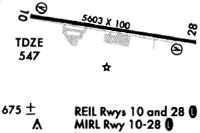
| A81-APT | ACTVT REIL RWY 10 & 28; MIRL RWY 10/28 - CTAF. PAPI RWY 10 & 28 ON CONSLY. |
| E111 | EXISTED PRIOR TO 1959. |
Runways
Runway Summary
| Runways: | 10/28 |
| Longest Runway: | 10/28 is 5402 ft (1647 m) long |
| Runways with an Instrument Approach: |
KDWU Airport Runway Details
| Runway 10/28 | 5402 ft x 100 ft (1647 m x 30 m) | |
| Runway Length Source: | 3RD PARTY SURVEY as of 06/12/2018 | |
| Surface: | Asphalt - Good condition - No special surface treatment | |
| Runway Pavement Class: | 15 /F/A/X/T | |
| Runway Edge Lights: | Medium Intensity | |
Runway Weight Bearing Capacity (in thousands of pounds) |
||
| Single Wheel Landing Gear: | 50.5 | |
| Dual Wheel Landing Gear: | 72.0 | |
| Dual Tandem Wheel Landing Gear: | 105.0 | |
Runway 10 |
Runway 28 |
|
Elevation: |
546.5 | 544.8 |
Latitude: |
38-33-19.8557N | 38-33-12.2597N |
Longitude: |
082-44-49.2377W | 082-43-41.9283W |
|
Runway True Alignment: |
098 | 278 |
Glide Path Angle: |
3.0 degrees | 4.0 degrees |
Traffic Pattern: |
Left | Left |
Runway Markings Type: |
Nonprecision Instrument | Nonprecision Instrument |
Runway Markings Condition: |
Good | Good |
Object at End: |
TREES | TREES |
Object Height: |
14 | 18 |
Distance from End: |
209 | 230 |
Object Centerline Offset: |
177 ft. left of centerline | 178 ft. left of centerline |
Visual Glide Slope Indicators: |
2-Light PAPI On Left Side Of Runway | 2-Light PAPI On Left Side Of Runway |
REIL: |
Yes | Yes |
Threshold Crossing Height: |
37 | 61 |
Services
Airframe Repair: |
None |
Powerplant Repair: |
None |
Bottled Oxygen: |
None |
Bulk Oxygen: |
None |
Fuel Available: |
100LL |
Landing Fees: |
No |
Parking: |
Hangars and tiedowns available |
Maps & Diagrams
KDWU Sectional
Flight Planning
at skyvector.com
at skyvector.com