Location
Latitude: |
36-47-18.0080N (36.788336) |
Longitude: |
078-30-05.5930W (-78.501554) |
Elevation: |
503.0 feet MSL (153 m MSL) |
Magnetic Variation: |
9.6 W (as of April 2024 from WMM2020 model) |
Time Zone: |
UTC -5.0 (Standard Time) UTC -4.0 (Daylight Savings Time) |
From City: |
02 N.M. W of Chase City, Virginia |
Found On: |
Washington Chart |
FAA Region: |
AEA |
Contacts
Manager: |
Publicly owned: |
| CHARLES FORBES 319 N MAIN ST CHASE CITY, VA 23924 434-372-5136 |
TOWN OF CHASE CITY 319 N MAIN ST CHASE CITY, VA 23924 434-372-5136 |
Operations
Airport Status: |
Operational |
Facility Use: |
Public |
Type: |
Airport |
Activation Date: |
09/1952 |
Control tower: |
No |
Attendance (Months/Days/Hours): |
Months/Days/Hours UNATTENDED |
Boundary ARTCC: |
ZDC (Washington) |
Responsible ARTCC: |
ZDC (Washington) |
Segmented Circle Indicator: |
No |
Traffic Pattern Altitude (MSL): |
1503 feet (458 m) |
NOTAMs Facility: |
DCA |
NOTAM-D Service: |
Yes |
International Airport of Entry: |
No |
Customs Landing Rights: |
No |
Military Landing Rights: |
Yes |
Civil/Military Joint Use: |
No |
Based Aircraft
| Single Engine: | 6 |
Annual Operations (as of 12/31/2019)
| Total Operations: | 2590 | |
| GA Local: | 595 | 23.0% |
| GA Itinerant: | 1995 | 77.0% |
Communications
| CTAF: | 122.900 |
| AWOS-3: | 121.225 (434-372-4506) |
- APCH/DEP SVC PRVDD BY WASHINGTON ARTCC ON FREQS 118.75/377.1 (GREEN BAY RCAG).
Fixed Based Operators (FBOs) & Fuel
(Click on a business for detail)
Please help us keep this information up to date. This is a FREE SERVICE just like everything else on Airport Guide! If you see that a business needs to be added, modified, or deleted please fill out our Update Form.
To add, modify, or delete a business click here.
Please help us keep this information up to date. This is a FREE SERVICE just like everything else on Airport Guide! If you see that a business needs to be added, modified, or deleted please fill out our Update Form.
Area Code: 804 |
| Business Name | Frequency | Phone | Fuel Grade |
|---|---|---|---|
| Chase City Flying Service
Update FBO info |
372-2727 | 100LL |
Flight Service Stations
| Primary | Alternate | |
| FSS on Field: | N | |
| FSS Name (ID): | Leesburg(DCA) | |
| Frequency: | ||
| Toll Free Phone: | 1-800-WX-BRIEF |
Instrument Procedures / Charts
FAA Terminal Procedures valid from 0901Z 03/21/24 to 0901Z 04/18/24.
There are various types of charts available for an airport. They are listed in the Page Type column. Here is a legend for those types:
APD - Airport Diagram
DP - Departure Procedure Charts
HOT - Hot Spots
IAP - Instrument Approach Procedure Charts
MIN - Minimums
STAR - Standard Terminal Arrival Charts
| Page Type | Page Name | Volume | Action Since Last Cycle |
|---|---|---|---|
| IAP | RNAV (GPS) RWY 18 | NE-3 | |
| IAP | RNAV (GPS) RWY 36 | NE-3 | |
| MIN | ALTERNATE MINIMUMS | NE-3 | |
| MIN | TAKEOFF MINIMUMS | NE-3 |
Terminal Procedures are only available for airports in several countries with more being added all the time. If you are looking for a specific country's charts, please send an email to support(at)airportguide.com stating the country name. This will be used to prioritize the implementation.
Navigation Aids (Navaids) near KCXE
| Dist (NM) | ID | Morse Code | Name | Type | Freq | True Hdg | Mag Hdg |
|---|---|---|---|---|---|---|---|
| 22.2 | MBV | _ _ _ . . . . . . _ | Mecklenburg/Dcmsnd | NDB | 356 | 104 | 114 |
| 24.0 | AEA | . _ . . _ | Jones | NDB | 373 | 115 | 125 |
| 25.6 | SBV | . . . _ . . . . . . _ | South Boston | VORTAC | 110.40 | 254 | 263 |
| 28.8 | LVL | . _ . . . . . _ . _ . . | Lawrenceville | VORTAC | 112.90 | 86 | 96 |
| 29.8 | HXO | . . . . _ . . _ _ _ _ | Huntsboro | NDB | 271 | 190 | 200 |
| 29.9 | BKT | _ . . . _ . _ _ | Blackstone | NDB | 326 | 46 | 56 |
| 34.0 | FVX | . . _ . . . . _ _ . . _ | Farmville | NDB | 367 | 5 | 15 |
| 42.3 | DAN | _ . . . _ _ . | Danville | VOR | 113.10 | 252 | 261 |
| 43.0 | HUR | . . . . . . _ . _ . | Person | NDB | 220 | 219 | 228 |
| 43.5 | RZZ | . _ . _ _ . . _ _ . . | Rapids | NDB | 407 | 118 | 128 |
| 45.0 | LYH | . _ . . _ . _ _ . . . . | Lynchburg | VOR-DME | 109.20 | 308 | 317 |
| 45.5 | LY | . _ . . _ . _ _ | Bojar | NDB | 385 | 308 | 317 |
| 52.8 | LE | . _ . . . | Leevy | NDB | 350 | 191 | 200 |
| 52.8 | ELQ | . . _ . . _ _ . _ | Emporia | NDB | 261 | 100 | 110 |
| 54.9 | FAK | . . _ . . _ _ . _ | Flat Rock | VORTAC | 113.30 | 35 | 45 |
| 56.6 | RDU | . _ . _ . . . . _ | Raleigh/Durham | VORTAC | 117.20 | 194 | 203 |
| 59.9 | CF | _ . _ . . . _ . | Pubbs | NDB | 392 | 56 | 66 |
| 62.1 | TYI | _ _ . _ _ . . | Tar River | VORTAC | 117.80 | 141 | 151 |
| 65.5 | SIF | . . . . . . . _ . | Slammer | NDB | 423 | 248 | 257 |
| 67.6 | OQA | _ _ _ _ _ . _ . _ | Rockingham County | FAN MARKER | 251 | 260 |
Nearby Airports with Fuel
Notices to Airmen (NOTAMS)
Remarks
| A110*G | THIS AIRPORT HAS BEEN SURVEYED BY THE NATIONAL GEODETIC SURVEY. |
| A110-1 | DEER ON AND INVOF ARPT. |
| A110-2 | FARM EQUIPMENT OPERATING NEAR RUNWAY. |
| A110-3 | ARPT CLSD SS-SR INDEFLY. |
| A110-4 | FOR CD CTC WASHINGTON ARTCC AT 703-771-3587. |
| A14 | TOWN MANAGER. |
| A33-18/36 | SEVERE RY CRACKING. 1-2 INCHES IN PLACES AND ALG CNTRLN. |
| A33-18/36 1 | LONGITUDINAL AND TRANSVERSE CRACKING. SOME RAVELING IN CERTAIN AREAS. |
| A42-18 | MARKINGS SEVERELY FADED |
| A42-18 1 | MARKINGS SEVERELY FADED AND RAVELING. |
| A42-36 | MARKINGS SEVERELY FADED |
| A42-36 1 | MARKINGS SEVERELY FADED AND RAVELING. |
| A58-18 | +6' GND; 115'R OF RY END; +20' ROAD 100' FM THR, 125'R. |
| A58-36 | RISING GROUND 150 FT FM END OF RY. |
Runways
Runway Summary
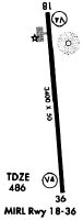
| Runways: | 18/36 |
| Longest Runway: | 18/36 is 3400 ft (1036 m) long |
| Runways with an Instrument Approach: |
KCXE Airport Runway Details
| Runway 18/36 | 3400 ft x 50 ft (1036 m x 15 m) | |
| Surface: | Asphalt - Poor condition - No special surface treatment | |
Runway Weight Bearing Capacity (in thousands of pounds) |
||
| Single Wheel Landing Gear: | 12.5 | |
Runway 18 |
Runway 36 |
|
Elevation: |
503.0 | 486.0 |
Latitude: |
36-47-34.6960N | 36-47-01.2250N |
Longitude: |
078-30-07.5280W | 078-30-03.6100W |
|
Runway True Alignment: |
175 | 355 |
Glide Path Angle: |
0.0 degrees | 0.0 degrees |
Traffic Pattern: |
Left | Left |
Runway Markings Type: |
Nonprecision Instrument | Nonprecision Instrument |
Runway Markings Condition: |
Poor | Poor |
Object at End: |
ROAD | BRUSH |
Object Height: |
23 | 32 |
Distance from End: |
200 | 237 |
Object Centerline Offset: |
108 ft. right of centerline | 117 ft. right of centerline |
Services
Airframe Repair: |
Major |
Powerplant Repair: |
Major |
Bottled Oxygen: |
None |
Bulk Oxygen: |
None |
Fuel Available: |
100LL, Jet A |
Landing Fees: |
No |
Parking: |
Tiedowns available |
Maps & Diagrams
KCXE Sectional
Flight Planning
at skyvector.com
at skyvector.com