Location
Latitude: |
33-06-09.1000N (33.102528) |
Longitude: |
094-11-42.1000W (-94.195028) |
Elevation: |
280.3 feet MSL (85 m MSL) |
Magnetic Variation: |
1.1 E (as of April 2024 from WMM2020 model) |
Time Zone: |
UTC -6.0 (Standard Time) UTC -5.0 (Daylight Savings Time) |
From City: |
02 N.M. SW of Atlanta, Texas |
Found On: |
Memphis Chart |
FAA Region: |
ASW |
Contacts
Manager: |
Publicly owned: |
| DANICA PORTER PO BOX 669 ATLANTA, TX 75551 903-796-2192 |
CITY OF ATLANTA CITY HALL 315 N BUCKER, P.O. BOX 669 ATLANTA, TX 75551 903-796-7153 |
Operations
Airport Status: |
Operational |
Facility Use: |
Public |
Type: |
Airport |
Activation Date: |
11/1946 |
Control tower: |
No |
Attendance (Months/Days/Hours): |
Months/Days/Hours IREG |
Boundary ARTCC: |
ZFW (Fort Worth) |
Responsible ARTCC: |
ZFW (Fort Worth) |
Lighting Schedule: |
SEE RMK |
Segmented Circle Indicator: |
Yes |
Traffic Pattern Altitude (MSL): |
1280 feet (390 m) |
NOTAMs Facility: |
FTW |
NOTAM-D Service: |
Yes |
International Airport of Entry: |
No |
Customs Landing Rights: |
No |
Military Landing Rights: |
Yes |
Civil/Military Joint Use: |
No |
Based Aircraft
| Single Engine: | 26 |
| Multi Engine: | 1 |
| Jet Engine: | 2 |
Annual Operations (as of 03/27/2019)
| Total Operations: | 20000 | |
| GA Local: | 15000 | 75.0% |
| GA Itinerant: | 5000 | 25.0% |
Communications
| CTAF: | 122.900 |
| AWOS-3: | 118.250 (903-799-4066) |
- APCH/DEP CTL SVC PRVDD BY FORT WORTH ARTCC (ZFW) ON FREQS 123.925/269.475 (TEXARKANA RCAG).
Fixed Based Operators (FBOs) & Fuel
(Click on a business for detail)
Please help us keep this information up to date. This is a FREE SERVICE just like everything else on Airport Guide! If you see that a business needs to be added, modified, or deleted please fill out our Update Form.
To add, modify, or delete a business click here.
Please help us keep this information up to date. This is a FREE SERVICE just like everything else on Airport Guide! If you see that a business needs to be added, modified, or deleted please fill out our Update Form.
Area Code: 903 |
| Business Name | Frequency | Phone | Fuel Grade |
|---|
Flight Service Stations
| Primary | Alternate | |
| FSS on Field: | N | |
| FSS Name (ID): | Fort Worth(FTW) | |
| Frequency: | ||
| Toll Free Phone: | 1-800-WX-BRIEF |
Instrument Procedures / Charts
FAA Terminal Procedures valid from 0901Z 03/21/24 to 0901Z 04/18/24.
There are various types of charts available for an airport. They are listed in the Page Type column. Here is a legend for those types:
APD - Airport Diagram
DP - Departure Procedure Charts
HOT - Hot Spots
IAP - Instrument Approach Procedure Charts
MIN - Minimums
STAR - Standard Terminal Arrival Charts
| Page Type | Page Name | Volume | Action Since Last Cycle |
|---|---|---|---|
| IAP | NDB RWY 05 | SC-2 | |
| IAP | RNAV (GPS) RWY 05 | SC-2 | |
| MIN | TAKEOFF MINIMUMS | SC-2 |
Terminal Procedures are only available for airports in several countries with more being added all the time. If you are looking for a specific country's charts, please send an email to support(at)airportguide.com stating the country name. This will be used to prioritize the implementation.
Navigation Aids (Navaids) near KATA
| Dist (NM) | ID | Morse Code | Name | Type | Freq | True Hdg | Mag Hdg |
|---|---|---|---|---|---|---|---|
| 0.3 | ATA | . _ _ . _ | Atlanta | NDB | 347 | 67 | 66 |
| 17.3 | VIV | . . . _ . . . . . _ | Vivian | NDB | 284 | 147 | 146 |
| 25.4 | TXK | _ _ . . _ _ . _ | Texarkana | VORTAC | 116.30 | 13 | 12 |
| 27.8 | EIC | . . . _ . _ . | Belcher | VORTAC | 117.40 | 135 | 134 |
| 29.2 | TX | _ _ . . _ | Tecco | NDB | 234 | 29 | 28 |
| 40.8 | DTN | _ . . _ _ . | Downtown | VOR | 108.60 | 145 | 144 |
| 43.3 | SHV | . . . . . . . . . . _ | Shreveport | VOT | 108.20 | 155 | 154 |
| 44.7 | BAD | _ . . . . _ _ . . | Barksdale | TACAN | 115.80 | 143 | 142 |
| 45.9 | HPC | . . . . . _ _ . _ . _ . | Hope | NDB | 362 | 36 | 35 |
| 49.3 | GG | _ _ . _ _ . | Veels | NDB | 410 | 218 | 217 |
| 49.8 | GGG | _ _ . _ _ . _ _ . | Gregg County | VORTAC | 112.90 | 214 | 213 |
| 51.9 | EMG | . _ _ _ _ . | Elm Grove | VORTAC | 111.20 | 144 | 143 |
| 55.6 | RPF | . _ . . _ _ . . . _ . | Carthage | NDB | 332 | 185 | 184 |
| 55.7 | ABG | . _ _ . . . _ _ . | Ambassador | NDB | 404 | 236 | 235 |
| 60.5 | UIM | . . _ . . _ _ | Quitman | DME | 114 | 257 | 256 |
| 64.4 | HNO | . . . . _ . _ _ _ | Henderson | NDB | 371 | 211 | 210 |
| 66.0 | MSD | _ _ . . . _ . . | Mansfield | NDB | 414 | 160 | 159 |
| 67.9 | SLR | . . . . _ . . . _ . | Sulphur Springs | DME | 109 | 275 | 274 |
| 68.2 | PRX | . _ _ . . _ . _ . . _ | Paris | VOR-DME | 113.60 | 293 | 292 |
| 73.5 | ELD | . . _ . . _ . . | El Dorado | VOR-DME | 115.50 | 82 | 81 |
Nearby Airports with Fuel
Notices to Airmen (NOTAMS)
Remarks
| A110-1 | FERAL HOGS & DEER ON ARPT. |
| A110-2 | RWY 23, 24 FT MKD POWERLINE 500 FT DSTC. |
| A110-3 | RWY 05 TRRN SLOPES +20 FT 670 FT FM THR. |
| A110-4 | RWY 33, 42 FT MKD POWERLINE, 285 FT DSTC. |
| A110-5 | FOR CD CTC FORT WORTH ARTCC AT 817-858-7584. |
| A14 | CITY/ARPT MGR. |
| A16 | EXT 120. |
| A42-15 | RWY MKD WITH 1 FT YELLOW PLASTIC PIPES. |
| A58-05 | 25 FT TREES, 0 FT DSTC, 165 FT R. |
| A58-23 | +40 FT TREES 0-199 FT FM THR 135-185 FT L. |
| A70-FUEL-10 | 0LL FUEL AVBL 24 HRS SELF-SERVE. |
| A81-APT | ACTVT REIL RWY 05 & 23; MIRL RWY 05/23 - CTAF. |
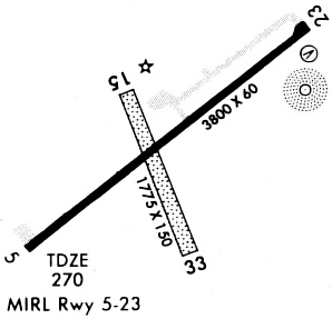
Runways
Runway Summary
| Runways: | 05/23 15/33 |
| Longest Runway: | 05/23 is 3800 ft (1158 m) long |
| Runways with an Instrument Approach: |
KATA Airport Runway Details
| Runway 05/23 | 3800 ft x 60 ft (1158 m x 18 m) | |
| Runway Length Source: | 3RD PARTY SURVEY as of 08/10/2011 | |
| Surface: | Asphalt - Excellent condition - No special surface treatment | |
| Runway Edge Lights: | Medium Intensity | |
Runway Weight Bearing Capacity (in thousands of pounds) |
||
| Single Wheel Landing Gear: | 12.5 | |
Runway 05 |
Runway 23 |
|
Elevation: |
280.3 | 268.2 |
Latitude: |
33-05-58.4499N | 33-06-21.5357N |
Longitude: |
094-11-58.8103W | 094-11-23.5513W |
|
Runway True Alignment: |
052 | 232 |
Glide Path Angle: |
4.0 degrees | 4.0 degrees |
Traffic Pattern: |
Left | Left |
Runway Markings Type: |
Nonprecision Instrument | Nonprecision Instrument |
Runway Markings Condition: |
Good | Good |
Object at End: |
TREES | TREES |
Object Height: |
40 | 50 |
Distance from End: |
275 | 201 |
Object Centerline Offset: |
245 ft. right of centerline | 202 ft. left of centerline |
Visual Glide Slope Indicators: |
2-Light PAPI On Left Side Of Runway | 2-Light PAPI On Left Side Of Runway |
REIL: |
Yes | Yes |
Threshold Crossing Height: |
29 | 30 |
| Runway 15/33 | 2264 ft x 75 ft (690 m x 23 m) | |
| Runway Length Source: | 3RD PARTY SURVEY as of 08/10/2011 | |
| Surface: | Asphalt - Excellent condition - No special surface treatment | |
Runway 15 |
Runway 33 |
|
Elevation: |
273.2 | 261.4 |
Latitude: |
33-06-17.9944N | 33-05-56.9792N |
Longitude: |
094-11-48.3445W | 094-11-39.1339W |
|
Runway True Alignment: |
160 | 340 |
Glide Path Angle: |
0.0 degrees | 0.0 degrees |
Traffic Pattern: |
Left | Left |
Object at End: |
TREES | TREES |
Object Height: |
80 | 35 |
Distance from End: |
200 | 0 |
Object Centerline Offset: |
245 ft. right of centerline | 202 ft. left of centerline |
Services
Airframe Repair: |
Minor |
Powerplant Repair: |
Major |
Bottled Oxygen: |
None |
Bulk Oxygen: |
None |
Fuel Available: |
100LL, Jet A+ |
Landing Fees: |
No |
Parking: |
Tiedowns available |
Maps & Diagrams
KATA Sectional
Flight Planning
at skyvector.com
at skyvector.com