Location
Latitude: |
38-54-14.6000N (38.904056) |
Longitude: |
097-14-09.1000W (-97.235861) |
Elevation: |
1152.5 feet MSL (351 m MSL) |
Magnetic Variation: |
3 E (as of April 2024 from WMM2020 model) |
Time Zone: |
UTC -6.0 (Standard Time) UTC -5.0 (Daylight Savings Time) |
From City: |
01 N.M. SW of Abilene, Kansas |
Found On: |
Wichita Chart |
FAA Region: |
ACE |
Contacts
Manager: |
Publicly owned: |
| JIM CURTIS 801 S. WASHINGTON ABILENE, KS 67410 785-263-3970 |
CITY OF ABILENE KANSAS CITY BUILDING ABILENE, KS 67410 785-263-2550 |
Operations
Airport Status: |
Operational |
Facility Use: |
Public |
Type: |
Airport |
Activation Date: |
05/1946 |
Control tower: |
No |
Attendance (Months/Days/Hours): |
Months/Days/Hours ALL/MON-SAT/0800-1700 |
Boundary ARTCC: |
ZKC (Kansas City) |
Responsible ARTCC: |
ZKC (Kansas City) |
Lighting Schedule: |
SEE RMK |
Segmented Circle Indicator: |
No |
Traffic Pattern Altitude (MSL): |
2152 feet (656 m) |
NOTAMs Facility: |
ICT |
NOTAM-D Service: |
Yes |
International Airport of Entry: |
No |
Customs Landing Rights: |
No |
Military Landing Rights: |
Yes |
Civil/Military Joint Use: |
No |
Based Aircraft
| Single Engine: | 12 |
Annual Operations (as of 10/24/2022)
| Total Operations: | 35600 | |
| Air Taxi: | 500 | 1.4% |
| GA Local: | 17000 | 47.8% |
| GA Itinerant: | 17800 | 50.0% |
| Military Aircraft: | 300 | 0.8% |
Communications
| CTAF: | 122.800 |
| Unicom: | 122.800 |
| Approach: | MARSHALL AAF GCA 121.25 121.25 KANSAS CITY ARTCC |
| Departure: | MARSHALL AAF GCA 121.25 121.25 KANSAS CITY ARTCC |
| AWOS-2: | 124.125 (785-802-8625) |
- APCH/DEP CTL SVC PRVDD BY KANSAS CITY ARTCC (ZKC) ON FREQS 134.9/363.2 (SALINA RCAG) WHEN MASHALL APCH CTL (FRI) CLSD.
Fixed Based Operators (FBOs) & Fuel
(Click on a business for detail)
Please help us keep this information up to date. This is a FREE SERVICE just like everything else on Airport Guide! If you see that a business needs to be added, modified, or deleted please fill out our Update Form.
To add, modify, or delete a business click here.
Please help us keep this information up to date. This is a FREE SERVICE just like everything else on Airport Guide! If you see that a business needs to be added, modified, or deleted please fill out our Update Form.
Area Code: 785 |
| Business Name | Frequency | Phone | Fuel Grade |
|---|---|---|---|
| Abilene Flying Service
Update FBO info |
263-3970 | 100LL, Jet A |
Flight Service Stations
| Primary | Alternate | |
| FSS on Field: | N | |
| FSS Name (ID): | Wichita(ICT) | |
| Frequency: | ||
| Toll Free Phone: | 1-800-WX-BRIEF |
Instrument Procedures / Charts
FAA Terminal Procedures valid from 0901Z 03/21/24 to 0901Z 04/18/24.
There are various types of charts available for an airport. They are listed in the Page Type column. Here is a legend for those types:
APD - Airport Diagram
DP - Departure Procedure Charts
HOT - Hot Spots
IAP - Instrument Approach Procedure Charts
MIN - Minimums
STAR - Standard Terminal Arrival Charts
| Page Type | Page Name | Volume | Action Since Last Cycle |
|---|---|---|---|
| IAP | RNAV (GPS) RWY 17 | NC-2 | |
| IAP | RNAV (GPS) RWY 35 | NC-2 | |
| IAP | VOR-A | NC-2 | |
| MIN | ALTERNATE MINIMUMS | NC-2 | |
| MIN | TAKEOFF MINIMUMS | NC-2 |
Terminal Procedures are only available for airports in several countries with more being added all the time. If you are looking for a specific country's charts, please send an email to support(at)airportguide.com stating the country name. This will be used to prioritize the implementation.
Navigation Aids (Navaids) near K78
| Dist (NM) | ID | Morse Code | Name | Type | Freq | True Hdg | Mag Hdg |
|---|---|---|---|---|---|---|---|
| 17.9 | FRI | . . _ . . _ . . . | Fort Riley | VOR | 109.40 | 77 | 74 |
| 18.0 | SLN | . . . . _ . . _ . | Salina | VORTAC | 117.10 | 274 | 271 |
| 21.9 | CVY | _ . _ . . . . _ _ . _ _ | Cavalry | NDB | 314 | 70 | 67 |
| 23.3 | SL | . . . . _ . . | Flory | NDB | 344 | 235 | 232 |
| 23.6 | HRU | . . . . . _ . . . _ | Herington | NDB | 407 | 122 | 119 |
| 28.8 | CYW | _ . _ . _ . _ _ . _ _ | Clay Center | NDB | 362 | 6 | 3 |
| 30.1 | MHK | _ _ . . . . _ . _ | Manhattan | VOR-DME | 110.20 | 61 | 58 |
| 39.5 | MPR | _ _ . _ _ . . _ . | Mc Pherson | NDB | 227 | 212 | 209 |
| 43.5 | CNK | _ . _ . _ . _ . _ | Concordia | NDB | 335 | 333 | 330 |
| 45.6 | CA | _ . _ . . _ | Harvs | NDB | 395 | 182 | 179 |
| 50.4 | EWK | . . _ _ _ . _ | Newton | NDB | 281 | 182 | 179 |
| 57.0 | HU | . . . . . . _ | Saltt | NDB | 404 | 214 | 211 |
| 57.2 | LYO | . _ . . _ . _ _ _ _ _ | Lyons | NDB | 386 | 234 | 231 |
| 58.0 | RPB | . _ . . _ _ . _ . . . | Republican | NDB | 414 | 340 | 337 |
| 63.3 | EMP | . _ _ . _ _ . | Emporia | VORTAC | 112.80 | 125 | 122 |
| 63.6 | HUT | . . . . . . _ _ | Hutchinson | VOR-DME | 116.80 | 211 | 208 |
| 71.4 | ICT | . . _ . _ . _ | Wichita | VORTAC | 113.80 | 193 | 190 |
| 72.0 | TKO | _ _ . _ _ _ _ | Mankato | VORTAC | 109.80 | 319 | 316 |
| 73.3 | FOE | . . _ . _ _ _ . | Forbes | VOT | 111.00 | 87 | 85 |
| 73.4 | TO | _ _ _ _ | Biloy | NDB | 521 | 79 | 77 |
Nearby Airports with Fuel
Notices to Airmen (NOTAMS)
Remarks
| A110-2 | COURTESY CAR AVBL. |
| A110-3 | AWOS FREQ. 124.125 |
| A110-4 | FOR CD CTC KANSAS CITY ARTCC AT 913-254-8508. |
| A110-5 | CTN - UNLGTD TREES ALONG RR 40-50 FT AGL, 549-787 FT FM RWY 17 THLD, 365 FT RIGHT, 340 FT LEFT. |
| A48-17 | REIL: LOW/ MEDIUM/ HIGH PILOT CTLD. |
| A55-17 | RR LOCATED 637 TO 864 FT FM RWY 17 END. |
| A70-FUEL-10 | 0LL 24 HR SELF SERVE FUEL. |
| A81-APT | FOR MIRL RWY 17/35, PAPI & REIL RYS 17 & 35 OPER DUSK-2200; AFTER 2200 ACTVT CTAF. |
Runways
Runway Summary
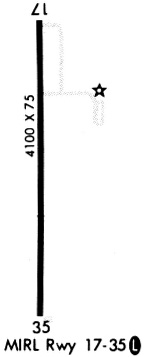
| Runways: | 17/35 |
| Longest Runway: | 17/35 is 4100 ft (1250 m) long |
| Runways with an Instrument Approach: |
K78 Airport Runway Details
| Runway 17/35 | 4100 ft x 75 ft (1250 m x 23 m) | |
| Runway Length Source: | 3RD PARTY SURVEY as of 01/20/2011 | |
| Surface: | Concrete - Good condition - No special surface treatment | |
| Runway Pavement Class: | 11 /R/C/X/U | |
| Runway Edge Lights: | Medium Intensity | |
Runway Weight Bearing Capacity (in thousands of pounds) |
||
| Single Wheel Landing Gear: | 13.0 | |
| Dual Wheel Landing Gear: | 16.0 | |
Runway 17 |
Runway 35 |
|
Elevation: |
1152.3 | 1149.8 |
Latitude: |
38-54-34.8556N | 38-53-54.3319N |
Longitude: |
097-14-09.0421W | 097-14-09.1024W |
|
Runway True Alignment: |
180 | 000 |
Glide Path Angle: |
3.8 degrees | 3.0 degrees |
Traffic Pattern: |
Left | Left |
Runway Markings Type: |
Nonprecision Instrument | Nonprecision Instrument |
Runway Markings Condition: |
Good | Good |
Object at End: |
TREE | ROAD |
Object Height: |
48 | 15 |
Distance from End: |
752 | 746 |
Object Centerline Offset: |
55 ft. right of centerline | 0 ft. left and right of centerline |
Visual Glide Slope Indicators: |
2-Light PAPI On Left Side Of Runway | 2-Light PAPI On Left Side Of Runway |
REIL: |
Yes | Yes |
Threshold Crossing Height: |
40 | 40 |
Declared Distances |
||
Take Off Run Avbl. (TORA): |
4100 | 4100 |
Take Off Distance Avbl. (TODA): |
4100 | 4100 |
Actual Stop Dist. Avbl. (ASDA): |
4100 | 4100 |
Landing Dist. Avbl. (LDA): |
4100 | 4100 |
Services
Fuel Available: |
100LL |
Landing Fees: |
No |
Parking: |
Tiedowns available |
Maps & Diagrams
K78 Sectional
Flight Planning
at skyvector.com
at skyvector.com