Location
Latitude: |
39-28-17.7660N (39.471602) |
Longitude: |
098-07-43.5230W (-98.128756) |
Elevation: |
1418.4 feet MSL (432 m MSL) |
Magnetic Variation: |
3.6 E (as of April 2024 from WMM2020 model) |
Time Zone: |
UTC -6.0 (Standard Time) UTC -5.0 (Daylight Savings Time) |
From City: |
01 N.M. NW of Beloit, Kansas |
Found On: |
Wichita Chart |
FAA Region: |
ACE |
Contacts
Manager: |
Publicly owned: |
| TRAVIS LATTIN FBO MORITZ MEMORIAL ARPT RR 3 BELOIT, KS 67420 785-738-7437 |
CITY OF BELOIT MUNICIPAL BLDG BELOIT, KS 67420 785-738-3551 |
Operations
Airport Status: |
Operational |
Facility Use: |
Public |
Type: |
Airport |
Activation Date: |
01/1942 |
Control tower: |
No |
Attendance (Months/Days/Hours): |
Months/Days/Hours ALL/MON-SAT/0800-1800 |
Boundary ARTCC: |
ZKC (Kansas City) |
Responsible ARTCC: |
ZKC (Kansas City) |
Lighting Schedule: |
SEE RMK |
Segmented Circle Indicator: |
Yes |
Traffic Pattern Altitude (MSL): |
2418 feet (737 m) |
NOTAMs Facility: |
ICT |
NOTAM-D Service: |
Yes |
International Airport of Entry: |
No |
Customs Landing Rights: |
No |
Military Landing Rights: |
Yes |
Civil/Military Joint Use: |
No |
Based Aircraft
| Single Engine: | 16 |
| Gliders: | 1 |
Annual Operations (as of 09/29/2020)
| Total Operations: | 20000 | |
| GA Local: | 12000 | 60.0% |
| GA Itinerant: | 8000 | 40.0% |
Communications
| CTAF: | 122.800 |
| Unicom: | 122.800 |
| AWOS-3: | 118.225 (785-534-1141) |
- APCH/DEP CTL SVC PRVDD BY KANSAS CITY ARTCC (ZKC) ON FREQS 134.9/363.2 (SALINA RCAG).
Fixed Based Operators (FBOs) & Fuel
(Click on a business for detail)
Please help us keep this information up to date. This is a FREE SERVICE just like everything else on Airport Guide! If you see that a business needs to be added, modified, or deleted please fill out our Update Form.
To add, modify, or delete a business click here.
Please help us keep this information up to date. This is a FREE SERVICE just like everything else on Airport Guide! If you see that a business needs to be added, modified, or deleted please fill out our Update Form.
Area Code: 785 |
| Business Name | Frequency | Phone | Fuel Grade |
|---|---|---|---|
| Sader Aviation Unlimited
Update FBO info |
Unicom 122.8 | 738-2770 | 100LL, MOGAS |
Flight Service Stations
| Primary | Alternate | |
| FSS on Field: | N | |
| FSS Name (ID): | Wichita(ICT) | |
| Frequency: | ||
| Toll Free Phone: | 1-800-WX-BRIEF |
Instrument Procedures / Charts
FAA Terminal Procedures valid from 0901Z 03/21/24 to 0901Z 04/18/24.
There are various types of charts available for an airport. They are listed in the Page Type column. Here is a legend for those types:
APD - Airport Diagram
DP - Departure Procedure Charts
HOT - Hot Spots
IAP - Instrument Approach Procedure Charts
MIN - Minimums
STAR - Standard Terminal Arrival Charts
| Page Type | Page Name | Volume | Action Since Last Cycle |
|---|---|---|---|
| IAP | RNAV (GPS) RWY 17 | NC-2 | |
| IAP | RNAV (GPS) RWY 35 | NC-2 | |
| IAP | VOR RWY 17 | NC-2 | |
| MIN | TAKEOFF MINIMUMS | NC-2 |
Terminal Procedures are only available for airports in several countries with more being added all the time. If you are looking for a specific country's charts, please send an email to support(at)airportguide.com stating the country name. This will be used to prioritize the implementation.
Navigation Aids (Navaids) near K61
| Dist (NM) | ID | Morse Code | Name | Type | Freq | True Hdg | Mag Hdg |
|---|---|---|---|---|---|---|---|
| 21.0 | TKO | _ _ . _ _ _ _ | Mankato | VORTAC | 109.80 | 343 | 339 |
| 22.6 | CNK | _ . _ . _ . _ . _ | Concordia | NDB | 335 | 77 | 74 |
| 29.9 | RPB | . _ . . _ _ . _ . . . | Republican | NDB | 414 | 46 | 43 |
| 40.4 | SLN | . . . . _ . . _ . | Salina | VORTAC | 117.10 | 144 | 141 |
| 45.2 | CYW | _ . _ . _ . _ _ . _ _ | Clay Center | NDB | 362 | 96 | 93 |
| 47.8 | HJH | . . . . . _ _ _ . . . . | Hebron | NDB | 323 | 31 | 28 |
| 52.5 | SL | . . . . _ . . | Flory | NDB | 344 | 154 | 151 |
| 55.4 | PHG | . _ _ . . . . . _ _ . | Phillipsburg | NDB | 368 | 285 | 281 |
| 61.3 | FBY | . . _ . _ . . . _ . _ _ | Fairbury | NDB | 293 | 46 | 43 |
| 65.2 | HYS | . . . . _ . _ _ . . . | Hays | VORTAC | 110.40 | 235 | 231 |
| 66.2 | FRI | . . _ . . _ . . . | Fort Riley | VOR | 109.40 | 116 | 113 |
| 67.1 | HY | . . . . _ . _ _ | Nette | NDB | 374 | 231 | 227 |
| 67.5 | CVY | _ . _ . . . . _ _ . _ _ | Cavalry | NDB | 314 | 112 | 109 |
| 67.6 | LYO | . _ . . _ . _ _ _ _ _ | Lyons | NDB | 386 | 183 | 179 |
| 69.4 | HSI | . . . . . . . . . | Hastings | VOR-DME | 108.80 | 348 | 344 |
| 70.5 | MPR | _ _ . _ _ . . _ . | Mc Pherson | NDB | 227 | 162 | 159 |
| 70.6 | MHK | _ _ . . . . _ . _ | Manhattan | VOR-DME | 110.20 | 105 | 102 |
| 71.9 | FMZ | . . _ . _ _ _ _ . . | Beklof | NDB | 392 | 20 | 17 |
| 74.6 | PSS | . _ _ . . . . . . . | Prosser | NDB | 338 | 347 | 343 |
| 75.9 | HIL | . . . . . . . _ . . | Hilyn | NDB | 338 | 208 | 204 |
Nearby Airports with Fuel
Notices to Airmen (NOTAMS)
Remarks
| A110-2 | RADIO CONTROLLED AIRCRAFT OPERATIONS ON AND INVOF ARPT WEEKENDS AND HOLIDAYS. |
| A110-3 | PILOT LOUNGE AVBL 24 HRS. |
| A110-4 | FOR CD CTC KANSAS CITY ARTCC AT 913-254-8508. |
| A42-04 | MKD WITH RED & WHITE PAINTED 'L' MKRS WITH ADDITIONAL REFLECTOR RAISED PANELS. |
| A42-08 | MKD WITH RED & WHITE PAINTED 'L' MKRS WITH ADDITIONAL REFLECTOR RAISED PANELS. |
| A42-22 | MKD WITH RED & WHITE PAINTED 'L' MKRS AT EACH END W/ ADDITIONAL REFLECTOR RAISED PANELS. |
| A42-26 | MKD WITH RED & WHITE PAINTED 'L' MKRS WITH ADDITIONAL REFLECTOR RAISED PANELS. |
| A52-26 | 461 FT LGTD TWR APRXLY 2 MI EAST. |
| A70-FUEL-10 | 0LL FOR FUEL AFT HRS CALL 785-738-7437 CREDIT CARD FUELING IS AVBL 24 HRS. |
| A70-FUEL-A | JET A AVBL 24 HRS WITH CREDIT CARD. |
| A81-APT | ACTVT PAPI RWY 17 & 35 - CTAF. |
Runways
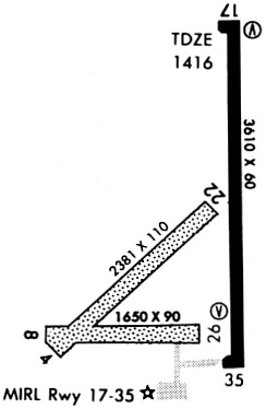
Runway Summary
| Runways: | 04/22 08/26 17/35 |
| Longest Runway: | 17/35 is 4200 ft (1280 m) long |
| Runways with an Instrument Approach: |
K61 Airport Runway Details
| Runway 04/22 | 2340 ft x 120 ft (713 m x 37 m) | |
| Runway Length Source: | 3RD PARTY SURVEY as of 09/10/2018 | |
| Surface: | Turf - Fair condition - No special surface treatment | |
Runway 04 |
Runway 22 |
|
Elevation: |
1408.4 | 1411.2 |
Latitude: |
39-28-03.7472N | 39-28-20.3100N |
Longitude: |
098-08-01.4122W | 098-07-40.5800W |
|
Runway True Alignment: |
044 | 224 |
Glide Path Angle: |
0.0 degrees | 0.0 degrees |
Traffic Pattern: |
Left | Left |
Runway Markings Type: |
Nonstandard (other than numbers only) | Nonstandard (other than numbers only) |
Runway Markings Condition: |
Fair | Fair |
| Runway 08/26 | 1666 ft x 70 ft (508 m x 21 m) | |
| Runway Length Source: | 3RD PARTY SURVEY as of 09/10/2018 | |
| Surface: | Turf - Fair condition - No special surface treatment | |
Runway 08 |
Runway 26 |
|
Elevation: |
1408.1 | 1413.2 |
Latitude: |
39-28-07.0997N | 39-28-06.9699N |
Longitude: |
098-08-00.0358W | 098-07-38.7909W |
|
Runway True Alignment: |
090 | 270 |
Glide Path Angle: |
0.0 degrees | 0.0 degrees |
Traffic Pattern: |
Left | Left |
Runway Markings Type: |
Nonstandard (other than numbers only) | Nonstandard (other than numbers only) |
Runway Markings Condition: |
Fair | Fair |
| Runway 17/35 | 4200 ft x 75 ft (1280 m x 23 m) | |
| Runway Length Source: | 3RD PARTY SURVEY as of 09/10/2018 | |
| Surface: | Turf - Fair condition - No special surface treatment | |
| Runway Pavement Class: | 11 /R/C/X/U | |
| Runway Edge Lights: | Medium Intensity | |
Runway Weight Bearing Capacity (in thousands of pounds) |
||
| Single Wheel Landing Gear: | 30.0 | |
| Dual Wheel Landing Gear: | 30.0 | |
Runway 17 |
Runway 35 |
|
Elevation: |
1417.8 | 1416.0 |
Latitude: |
39-28-45.9666N | 39-28-04.4773N |
Longitude: |
098-07-37.5195W | 098-07-36.5204W |
|
Runway True Alignment: |
179 | 359 |
Glide Path Angle: |
4.0 degrees | 3.0 degrees |
Traffic Pattern: |
Left | Left |
Runway Markings Type: |
Nonprecision Instrument | Nonprecision Instrument |
Runway Markings Condition: |
Good | Good |
Object at End: |
ROAD | TREES |
Object Height: |
25 | 48 |
Distance from End: |
649 | 1400 |
Visual Glide Slope Indicators: |
2-Light PAPI On Left Side Of Runway | 2-Light PAPI On Left Side Of Runway |
Threshold Crossing Height: |
40 | 40 |
Threshold Elevation: |
1418.3 | |
Displaced Threshold: |
181 | |
Threshold Latitude: |
39-28-44.1761N | |
Threshold Longitude: |
098-07-37.4757W | |
Declared Distances |
||
Take Off Run Avbl. (TORA): |
4200 | 4200 |
Take Off Distance Avbl. (TODA): |
4200 | 4200 |
Actual Stop Dist. Avbl. (ASDA): |
4200 | 4200 |
Landing Dist. Avbl. (LDA): |
4018 | 4200 |
Services
Bottled Oxygen: |
None |
Bulk Oxygen: |
None |
Fuel Available: |
100LL |
Landing Fees: |
No |
Parking: |
Tiedowns available |
Maps & Diagrams
K61 Sectional
Flight Planning
at skyvector.com
at skyvector.com