
Location
Latitude: |
34-47-07.7985N (34.7855) |
Longitude: |
135-26-16.8127E (135.438004) |
Elevation: |
50 feet MSL (15 m MSL) |
Magnetic Variation: |
8.2 W (as of April 2024 from WMM2020 model) |
Time Zone: |
UTC +9.0 (Standard Time) UTC +9.0 (Daylight Savings Time) |
Contacts
Manager: |
: |
Operations
Airport Status: |
Operational |
Facility Use: |
Public |
Type: |
Airport |
Traffic Pattern Altitude (MSL): |
1050 feet (320 m) |
Based Aircraft
Annual Operations (as of )
Communications
| TWR: | 118.1 |
| CLNC DEL: | 118.8 |
| GND: | 121.7 |
| KANSAI APP: | 120.45 |
| KANSAI DEP: | 119.5 |
| ATIS: | 128.6 |
| GCA: | 127.5 |
| TCA: | 121.1 |
Fixed Based Operators (FBOs) & Fuel
(Click on a business for detail)
Please help us keep this information up to date. This is a FREE SERVICE just like everything else on Airport Guide! If you see that a business needs to be added, modified, or deleted please fill out our Update Form.
To add, modify, or delete a business click here.
Please help us keep this information up to date. This is a FREE SERVICE just like everything else on Airport Guide! If you see that a business needs to be added, modified, or deleted please fill out our Update Form.
| Business Name | Frequency | Phone | Fuel Grade |
|---|
Flight Service Stations
| Primary | Alternate | |
| FSS on Field: | ||
| FSS Name (ID): | ||
| Frequency: | ||
| Toll Free Phone: |
Instrument Procedures / Charts
Terminal Procedures are only available for airports in several countries with more being added all the time. If you are looking for a specific country's charts, please send an email to support(at)airportguide.com stating the country name. This will be used to prioritize the implementation.
Navigation Aids (Navaids) near ITM
| Dist (NM) | ID | Morse Code | Name | Type | Freq | True Hdg | Mag Hdg |
|---|---|---|---|---|---|---|---|
| 0.9 | OWE | Osaka | VOR-DME | 113.90 | 129 | 137 | |
| 2.1 | OW | Itami | NDB | 211 | 305 | 313 | |
| 8.1 | RK | Osaka | NDB | 340 | 136 | 144 | |
| 13.6 | YOE | Yao | VOR-DME | 114.60 | 145 | 153 | |
| 13.9 | KCE | Kobe | VOR-DME | 111.25 | 228 | 236 | |
| 14.5 | SIE | Shigi | VOR-DME | 111.60 | 130 | 138 | |
| 17.6 | SKE | Shinoda | VOR-DME | 112.30 | 178 | 186 | |
| 17.7 | SK | Shinoda | NDB | 219 | 179 | 187 | |
| 18.0 | KN | Kansai | NDB | 346 | 194 | 202 | |
| 23.2 | KNE | Kansai | VOR-DME | 111.80 | 203 | 211 | |
| 23.6 | CUE | Otsu | VOR-DME | 117.10 | 53 | 61 | |
| 26.6 | CU | Otsu | NDB | 368 | 53 | 61 | |
| 37.1 | TME | Tomo | VOR-DME | 116.40 | 215 | 223 | |
| 44.2 | YME | Miyazu | VOR-DME | 112.60 | 340 | 348 | |
| 45.8 | MZT | Maizuru | TACAN | 109.65 | 359 | 367 | |
| 47.3 | AJE | Awaji | VOR-DME | 115.60 | 229 | 237 | |
| 54.2 | THE | Tajima | VOR-DME | 110.45 | 324 | 332 | |
| 55.0 | GBE | Goboh | VOR-DME | 116.90 | 197 | 205 | |
| 56.8 | TSC | Tokushima | VORTAC | 114.90 | 226 | 234 | |
| 57.0 | TS | Tokushima | NDB | 333 | 226 | 234 |
Nearby Airports with Fuel
| Dist (NM) | Name (Airport IDs) | True Hdg | Mag Hdg | Fuel Grade |
|---|---|---|---|---|
| 14.0 | Kobe Airport (UKB RJBE) |
229 | 237 | Please confirm |
Notices to Airmen (NOTAMS)
Remarks
No remarks for this landing facility
Runways
Runway Summary
| Runways: | 14L/32R 14R/32L |
| Longest Runway: | 14R/32L is 9840 ft (2999 m) long |
| Runways with an Instrument Approach: |
ITM Airport Runway Details
| Runway 14L/32R | 5997 ft x 150 ft (1828 m x 46 m) | |
| Runway Edge Lights: | Yes Intensity | |
Runway 14L |
Runway 32R |
|
Elevation: |
50 | 34 |
Latitude: |
34.79529953002 | 34.78359985351 |
Longitude: |
135.42900085449 | 135.44299316406 |
|
Runway True Alignment: |
135 | 315 |
Glide Path Angle: |
0.0 degrees | 0.0 degrees |
REIL: |
Yes | Yes |
Threshold Elevation: |
50 | 34 |
| Runway 14R/32L | 9840 ft x 200 ft (2999 m x 61 m) | |
| Runway Edge Lights: | Yes Intensity | |
Runway 14R |
Runway 32L |
|
Elevation: |
46 | 31 |
Latitude: |
34.79130172729 | 34.77220153808 |
Longitude: |
135.42900085449 | 135.45199584960 |
|
Runway True Alignment: |
135 | 315 |
Glide Path Angle: |
0.0 degrees | 0.0 degrees |
REIL: |
Yes | Yes |
Threshold Elevation: |
46 | 31 |
Services
Fuel Available: |
Please confirm |
Maps & Diagrams
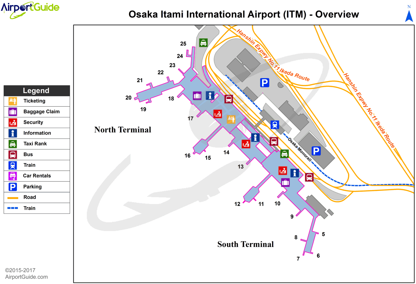
ITM Sectional
Flight Planning
at skyvector.com
at skyvector.com
