
Location
Latitude: |
51-31-05.8768N (51.518299) |
Longitude: |
007-36-44.0634E (7.61224) |
Elevation: |
425 feet MSL (130 m MSL) |
Magnetic Variation: |
3.3 E (as of April 2024 from WMM2020 model) |
Time Zone: |
UTC +1.0 (Standard Time) UTC +2.0 (Daylight Savings Time) |
Contacts
Manager: |
: |
Operations
Airport Status: |
Operational |
Facility Use: |
Public |
Type: |
Airport |
Traffic Pattern Altitude (MSL): |
1425 feet (434 m) |
Based Aircraft
Annual Operations (as of )
Communications
| LANGEN INFO: | 129.875 |
| TWR: | 134.18 |
| GND: | 121.83 |
| LANGEN RADAR: | 125.225 |
| ATIS: | 125.125 |
Fixed Based Operators (FBOs) & Fuel
(Click on a business for detail)
Please help us keep this information up to date. This is a FREE SERVICE just like everything else on Airport Guide! If you see that a business needs to be added, modified, or deleted please fill out our Update Form.
To add, modify, or delete a business click here.
Please help us keep this information up to date. This is a FREE SERVICE just like everything else on Airport Guide! If you see that a business needs to be added, modified, or deleted please fill out our Update Form.
| Business Name | Frequency | Phone | Fuel Grade |
|---|
Flight Service Stations
| Primary | Alternate | |
| FSS on Field: | ||
| FSS Name (ID): | ||
| Frequency: | ||
| Toll Free Phone: |
Instrument Procedures / Charts
Terminal Procedures are only available for airports in several countries with more being added all the time. If you are looking for a specific country's charts, please send an email to support(at)airportguide.com stating the country name. This will be used to prioritize the implementation.
Navigation Aids (Navaids) near DTM
| Dist (NM) | ID | Morse Code | Name | Type | Freq | True Hdg | Mag Hdg |
|---|---|---|---|---|---|---|---|
| 0.8 | DOR | Wickede | VOR-DME | 108.65 | 59 | 56 | |
| 1.0 | DWI | Dortmund | NDB | 357 | 60 | 57 | |
| 11.5 | DOM | Dortmund | VOR-DME | 112.70 | 355 | 352 | |
| 19.9 | BAM | Barmen | VORTAC | 113.60 | 235 | 232 | |
| 20.6 | HMM | Hamm | VOR-DME | 115.65 | 9 | 6 | |
| 22.4 | BOT | Bottrop | NDB | 407 | 280 | 277 | |
| 23.4 | GMH | Germinghausen | VOR-DME | 115.40 | 153 | 150 | |
| 28.9 | LI | Dusseldorf | NDB | 417 | 249 | 246 | |
| 30.8 | WYP | Wipper | VOR | 109.60 | 203 | 200 | |
| 35.1 | DUS | Dusseldorf | VOR-DME | 115.15 | 246 | 243 | |
| 35.5 | MST | Greven | NDB | 305 | 357 | 354 | |
| 37.3 | MOD | Munster | DME | 114.05 | 4 | 1 | |
| 38.8 | PAD | Paderborn/Lippstadt | NDB-DME | 354 | 80 | 77 | |
| 39.1 | MYN | Munster | NDB | 371 | 10 | 7 | |
| 39.6 | LW | Koln/Bonn | NDB | 301 | 200 | 197 | |
| 41.1 | LJ | Koln/Bonn | NDB | 365 | 210 | 207 | |
| 43.1 | KBO | Koln/Bonn | VOR-DME | 112.15 | 204 | 201 | |
| 44.1 | COL | Cola | VORTAC | 108.80 | 180 | 177 | |
| 45.0 | MGB | Monchengladbach | NDB | 377 | 247 | 244 | |
| 45.1 | LV | Koln/Bonn | NDB | 327 | 198 | 195 |
Nearby Airports with Fuel
| Dist (NM) | Name (Airport IDs) | True Hdg | Mag Hdg | Fuel Grade |
|---|
Notices to Airmen (NOTAMS)
Remarks
No remarks for this landing facility
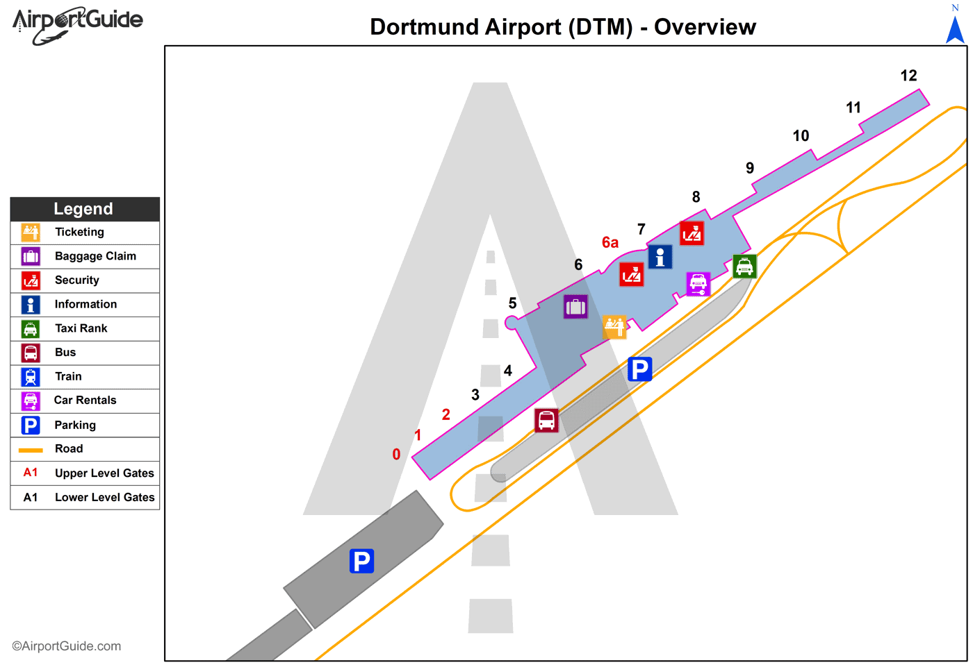
Runways
Runway Summary
| Runways: | 06/24 |
| Longest Runway: | 06/24 is 6562 ft (2000 m) long |
| Runways with an Instrument Approach: |
DTM Airport Runway Details
| Runway 06/24 | 6562 ft x 148 ft (2000 m x 45 m) | |
| Runway Edge Lights: | Yes Intensity | |
Runway 06 |
Runway 24 |
|
Elevation: |
418 | 401 |
Latitude: |
51.51470184326 | 51.52349853515 |
Longitude: |
7.6019001007080 | 7.6269898414611 |
|
Runway True Alignment: |
61 | 241 |
Glide Path Angle: |
0.0 degrees | 0.0 degrees |
REIL: |
Yes | Yes |
Threshold Elevation: |
418 | 401 |
Displaced Threshold: |
984 | 984 |
Services
Maps & Diagrams
DTM Sectional
Flight Planning
at skyvector.com
at skyvector.com
