Location
Latitude: |
37-09-05.5000N (37.151528) |
Longitude: |
107-45-13.6000W (-107.753778) |
Elevation: |
6689.4 feet MSL (2039 m MSL) |
Magnetic Variation: |
8.7 E (as of April 2024 from WMM2020 model) |
Time Zone: |
UTC -7.0 (Standard Time) UTC -6.0 (Daylight Savings Time) |
From City: |
10 N.M. SE of Durango, Colorado |
Found On: |
Denver Chart |
FAA Region: |
ANM |
Contacts
Manager: |
Publicly owned: |
| ANTHONY VICARI - DIR OF AVIATION 1000 AIRPORT ROAD BOX 15 DURANGO, CO 81303 (970) 382-6051 |
DURANGO CITY LA PLATA CO 1000 AIRPORT ROAD BOX 15 DURANGO, CO 81303 970-382-6050 |
Operations
Airport Status: |
Operational |
Facility Use: |
Public |
Type: |
Airport |
Activation Date: |
11/1946 |
Control tower: |
No |
Attendance (Months/Days/Hours): |
Months/Days/Hours ALL/ALL/0400-2400 |
Boundary ARTCC: |
ZDV (Denver) |
Responsible ARTCC: |
ZDV (Denver) |
Lighting Schedule: |
SEE RMK |
Segmented Circle Indicator: |
Yes |
Traffic Pattern Altitude (MSL): |
7689 feet (2344 m) |
NOTAMs Facility: |
DRO |
NOTAM-D Service: |
Yes |
International Airport of Entry: |
No |
Customs Landing Rights: |
No |
Military Landing Rights: |
Yes |
Civil/Military Joint Use: |
No |
Aircraft Rescue and Firefighting: |
Class I ARFF Index: B Air Carrier Service: Scheduled Certification Date: 05/1973 |
Based Aircraft
| Single Engine: | 58 |
| Multi Engine: | 12 |
| Jet Engine: | 6 |
| GA Helicopters: | 3 |
| Gliders: | 2 |
Annual Operations (as of 07/31/2023)
| Total Operations: | 20400 | |
| Commercial: | 7652 | 37.5% |
| Air Taxi: | 1488 | 7.3% |
| GA Local: | 2685 | 13.2% |
| GA Itinerant: | 8503 | 41.7% |
| Military Aircraft: | 72 | 0.4% |
Communications
| CTAF: | 122.800 |
| Unicom: | 122.800 |
| ASOS: | 120.625 (970-259-3579) |
- APCH/DEP CTL SVC PRVDD BY DENVER ARTCC (ZDV) ON FREQS 118.575/348.7 (DURANGO RCAG).
Fixed Based Operators (FBOs) & Fuel
(Click on a business for detail)
Please help us keep this information up to date. This is a FREE SERVICE just like everything else on Airport Guide! If you see that a business needs to be added, modified, or deleted please fill out our Update Form.
To add, modify, or delete a business click here.
Please help us keep this information up to date. This is a FREE SERVICE just like everything else on Airport Guide! If you see that a business needs to be added, modified, or deleted please fill out our Update Form.
Area Code: 970 |
| Business Name | Frequency | Phone | Fuel Grade |
|---|---|---|---|
| Durango Air Service, Inc.
Update FBO info |
Unicom 122.8 | 247-5535, -1987 | 100LL, Jet A |
Flight Service Stations
| Primary | Alternate | |
| FSS on Field: | N | |
| FSS Name (ID): | Denver(DEN) | |
| Frequency: | ||
| Toll Free Phone: | 1-800-WX-BRIEF |
Instrument Procedures / Charts
FAA Terminal Procedures valid from 0901Z 03/21/24 to 0901Z 04/18/24.
There are various types of charts available for an airport. They are listed in the Page Type column. Here is a legend for those types:
APD - Airport Diagram
DP - Departure Procedure Charts
HOT - Hot Spots
IAP - Instrument Approach Procedure Charts
MIN - Minimums
STAR - Standard Terminal Arrival Charts
| Page Type | Page Name | Volume | Action Since Last Cycle |
|---|---|---|---|
| IAP | ILS OR LOC/DME RWY 03 | SW-1 | |
| IAP | RNAV (GPS) RWY 03 | SW-1 | |
| IAP | RNAV (GPS) RWY 21 | SW-1 | |
| MIN | ALTERNATE MINIMUMS | SW-1 | |
| MIN | TAKEOFF MINIMUMS | SW-1 |
Terminal Procedures are only available for airports in several countries with more being added all the time. If you are looking for a specific country's charts, please send an email to support(at)airportguide.com stating the country name. This will be used to prioritize the implementation.
Navigation Aids (Navaids) near DRO
| Dist (NM) | ID | Morse Code | Name | Type | Freq | True Hdg | Mag Hdg |
|---|---|---|---|---|---|---|---|
| 0.2 | DRO | _ . . . _ . _ _ _ | Durango | VOR-DME | 116.55 | 61 | 52 |
| 29.3 | RSK | . _ . . . . _ . _ | Rattlesnake | VORTAC | 115.30 | 214 | 205 |
| 41.1 | CEZ | _ . _ . . _ _ . . | Cortez | VOR-DME | 114.35 | 290 | 281 |
| 58.5 | ETL | . _ . _ . . | Cones | VOR-DME | 110.20 | 335 | 326 |
| 68.5 | DVC | _ . . . . . _ _ . _ . | Dove Creek | VORTAC | 114.60 | 305 | 296 |
| 81.6 | MTJ | _ _ _ . _ _ _ | Montrose | VOR-DME | 117.10 | 355 | 346 |
| 85.1 | HBU | . . . . _ . . . . . _ | Blue Mesa | VOR-DME | 114.90 | 23 | 14 |
| 93.3 | ALS | . _ . _ . . . . . | Alamosa | VORTAC | 113.90 | 82 | 74 |
| 94.5 | TAS | _ . _ . . . | Taos | VORTAC | 115.80 | 109 | 101 |
Nearby Airports with Fuel
| Dist (NM) | Name (Airport IDs) | True Hdg | Mag Hdg | Fuel Grade |
|---|---|---|---|---|
| 6.3 | Animas Air Park Airport (AMK 00C) |
299 | 290 | 100LL, Jet A |
| 33.6 | Four Corners Regional Airport (FMN KFMN FMN) |
222 | 213 | 100LL, Jet A, Jet A-1+ |
| 34.3 | Stevens Field Airport (PGO KPSO PSO) |
76 | 68 | 100LL, Jet A |
| 42.7 | Cortez Municipal Airport (CEZ KCEZ CEZ) |
282 | 273 | 100LL, Jet A |
| 48.7 | Telluride Regional Airport (TEX KTEX TEX) |
351 | 342 | 100LL, Jet A |
| 75.7 | Hopkins Field Airport (KAIB AIB) |
329 | 320 | 100LL, Jet A |
| 81.8 | Montrose Regional Airport (MTJ KMTJ MTJ) |
355 | 346 | 100LL, Jet A+ |
| 84.6 | Monte Vista Municipal Airport (KMVI MVI) |
73 | 65 | 100LL |
| 86.4 | Blanding Municipal Airport (BDG KBDG BDG) |
287 | 278 | 100LL, Jet A |
| 88.9 | Monticello Airport (U64) |
302 | 293 | 100LL, Jet A |
| 89.7 | Leach Airport (1V8) |
64 | 56 | 100LL |
| 91.6 | San Luis Valley Regional/Bergman Field Airport (ALS KALS ALS) |
78 | 70 | 100LL, Jet A |
| 91.7 | Gunnison-Crested Butte Regional Airport (GUC KGUC GUC) |
24 | 16 | 100LL, Jet A+ |
| 93.3 | Crawford Airport (99V) |
3 | 354 | 100LL |
| 99.1 | Blake Field Airport (KAJZ AJZ) |
351 | 342 | 100LL, Jet A |
Notices to Airmen (NOTAMS)
Remarks
| A110-1 | COND UNMNT AT NGT AFT LAST ACR ARR UNTIL 0400; SEE NOTAMS. |
| A110-3 | ARFF COVERAGE PRVDD DURG ACR TFC OPS; OTR TIMES 24 HR PPR - ARPT OPS 970-759-4342. |
| A110-4 | HOP ON & INVOF ARPT. |
| A110-5 | FOR CD CTC DENVER ARTCC ON FREQ. IF UNA, CTC FSS ON FREQ VIA RCO. IF UNA, CTC DENVER ARTCC AT 303-651-4257. |
| A17 | AFT HR - 970-259-7400. |
| A26 | PPR FOR UNSKED ACR OPS WITH MORE THAN 30 PAX SEATS - ARPT OPS 970-759-4342. |
| A81-APT | MALSR RWY 03; REIL RWY 21; HIRL RWY 03/21 OPER ON PHOTOCELL; INCR/DECR INTST - CTAF. PAPI RWY 03 & 21 ON CONSLY; INCR/DECR INTST - CTAF. |
Runways
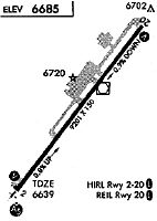
Runway Summary
| Runways: | 03/21 |
| Longest Runway: | 03/21 is 9201 ft (2804 m) long |
| Runways with an Instrument Approach: | 03 |
DRO Airport Runway Details
| Runway 03/21 | 9201 ft x 150 ft (2804 m x 46 m) | |
| Runway Length Source: | 3RD PARTY SURVEY as of 08/17/2014 | |
| Surface: | Asphalt - Good condition - Saw-cut or plastic grooved | |
| Runway Pavement Class: | 59 /F/C/X/T | |
| Runway Edge Lights: | High Intensity | |
Runway Weight Bearing Capacity (in thousands of pounds) |
||
| Single Wheel Landing Gear: | 95.0 | |
| Dual Wheel Landing Gear: | 150.0 | |
| Dual Tandem Wheel Landing Gear: | 210.0 | |
Runway 03 |
Runway 21 |
|
Elevation: |
6619.7 | 6689.3 |
Latitude: |
37-08-29.3300N | 37-09-41.5994N |
Longitude: |
107-45-48.0447W | 107-44-39.0840W |
|
Runway True Alignment: |
037 | 217 |
ILS Type: |
ILS | |
Glide Path Angle: |
3.0 degrees | 3.0 degrees |
Traffic Pattern: |
Left | Left |
Runway Markings Type: |
Precision Instrument | Precision Instrument |
Runway Markings Condition: |
Good | Good |
Visual Glide Slope Indicators: |
4-Light PAPI On Left Side Of Runway | 4-Light PAPI On Left Side Of Runway |
Approach Light System: |
1,400 Foot Medium Intensity Approach Lighting System With Runway Alignment Indicator Lights | |
REIL: |
Yes | |
Threshold Crossing Height: |
55 | 51 |
Declared Distances |
||
Take Off Run Avbl. (TORA): |
9201 | 9201 |
Take Off Distance Avbl. (TODA): |
9201 | 9201 |
Actual Stop Dist. Avbl. (ASDA): |
9201 | 9201 |
Landing Dist. Avbl. (LDA): |
9201 | 9201 |
Services
Airframe Repair: |
Major |
Powerplant Repair: |
Minor |
Bottled Oxygen: |
High Pressure |
Bulk Oxygen: |
None |
Fuel Available: |
100LL, Jet A |
Landing Fees: |
No |
Parking: |
Hangars and tiedowns available |
Maps & Diagrams
DRO Sectional
Flight Planning
at skyvector.com
at skyvector.com