Location
Latitude: |
34-26-56.6000N (34.449056) |
Longitude: |
079-22-06.9000W (-79.368583) |
Elevation: |
133.1 feet MSL (41 m MSL) |
Magnetic Variation: |
8.8 W (as of April 2024 from WMM2020 model) |
Time Zone: |
UTC -5.0 (Standard Time) UTC -4.0 (Daylight Savings Time) |
From City: |
03 N.M. N of Dillon, South Carolina |
Found On: |
Charlotte Chart |
FAA Region: |
ASO |
Contacts
Manager: |
Publicly owned: |
| CASSIE KINNEY PO BOX 449 DILLON, SC 29536 843-845-8529 |
DILLON COUNTY PO BOX 449 DILLON, SC 29536 (843) 774-1401 |
Operations
Airport Status: |
Operational |
Facility Use: |
Public |
Type: |
Airport |
Activation Date: |
08/1960 |
Control tower: |
No |
Attendance (Months/Days/Hours): |
Months/Days/Hours Unattended |
Boundary ARTCC: |
ZJX (Jacksonville) |
Responsible ARTCC: |
ZJX (Jacksonville) |
Lighting Schedule: |
SS-SR |
Segmented Circle Indicator: |
Yes |
Traffic Pattern Altitude (MSL): |
1133 feet (345 m) |
NOTAMs Facility: |
AND |
NOTAM-D Service: |
Yes |
International Airport of Entry: |
No |
Customs Landing Rights: |
No |
Military Landing Rights: |
Yes |
Civil/Military Joint Use: |
No |
Based Aircraft
Annual Operations (as of 06/08/2021)
| Total Operations: | 310 | |
| GA Local: | 168 | 54.2% |
| GA Itinerant: | 112 | 36.1% |
| Military Aircraft: | 30 | 9.7% |
Communications
| CTAF: | 122.900 |
| Approach: | FLORENCE 118.6 118.6 JAX ARTCC |
| Departure: | FLORENCE 118.6 118.6 JAX ARTCC |
- APCH/DEP SVC PRVDD BY JACKSONVILLE ARTCC ON FREQS 133.45/306.3 (FLORENCE RCAG) WHEN FLORENCE APCH CTL CLSD.
Fixed Based Operators (FBOs) & Fuel
(Click on a business for detail)
Please help us keep this information up to date. This is a FREE SERVICE just like everything else on Airport Guide! If you see that a business needs to be added, modified, or deleted please fill out our Update Form.
To add, modify, or delete a business click here.
Please help us keep this information up to date. This is a FREE SERVICE just like everything else on Airport Guide! If you see that a business needs to be added, modified, or deleted please fill out our Update Form.
Area Code: 843 |
| Business Name | Frequency | Phone | Fuel Grade |
|---|---|---|---|
| Price Flying Service
Update FBO info |
Unicom 122.8 | 774-2636 | 100LL, Mogas |
Flight Service Stations
| Primary | Alternate | |
| FSS on Field: | N | |
| FSS Name (ID): | Anderson(AND) | |
| Frequency: | ||
| Toll Free Phone: | 1-800-WX-BRIEF |
Instrument Procedures / Charts
FAA Terminal Procedures valid from 0901Z 03/21/24 to 0901Z 04/18/24.
There are various types of charts available for an airport. They are listed in the Page Type column. Here is a legend for those types:
APD - Airport Diagram
DP - Departure Procedure Charts
HOT - Hot Spots
IAP - Instrument Approach Procedure Charts
MIN - Minimums
STAR - Standard Terminal Arrival Charts
| Page Type | Page Name | Volume | Action Since Last Cycle |
|---|---|---|---|
| IAP | VOR/DME OR GPS RWY 07 | SE-2 | |
| MIN | TAKEOFF MINIMUMS | SE-2 |
Terminal Procedures are only available for airports in several countries with more being added all the time. If you are looking for a specific country's charts, please send an email to support(at)airportguide.com stating the country name. This will be used to prioritize the implementation.
Navigation Aids (Navaids) near DLL
| Dist (NM) | ID | Morse Code | Name | Type | Freq | True Hdg | Mag Hdg |
|---|---|---|---|---|---|---|---|
| 0.1 | DLC | _ . . . _ . . _ . _ . | Dillon | NDB | 274 | 350 | 359 |
| 12.8 | JB | . _ _ _ _ . . . | Jigel | NDB | 384 | 62 | 71 |
| 15.9 | MAO | _ _ . _ _ _ _ | Marion | NDB | 388 | 173 | 182 |
| 17.4 | ME | _ _ . | Maxtn | NDB | 257 | 347 | 356 |
| 18.2 | RSY | . _ . . . . _ . _ _ | Robeson | NDB | 359 | 56 | 65 |
| 18.2 | LBT | . _ . . _ . . . _ | Lumberton | VOR | 110.00 | 57 | 66 |
| 19.3 | FLO | . . _ . . _ . . _ _ _ | Florence | VORTAC | 115.20 | 227 | 236 |
| 20.7 | BES | _ . . . . . . . | Bennettsville | NDB | 230 | 299 | 308 |
| 25.7 | UDG | . . _ _ . . _ _ . | Darlington | NDB | 245 | 269 | 278 |
| 29.1 | FL | . . _ . . _ . . | Alcot | NDB | 335 | 235 | 244 |
| 30.2 | CQW | _ . _ . _ _ . _ . _ _ | Cheraw | NDB | 409 | 305 | 314 |
| 34.2 | CPC | _ . _ . . _ _ . _ . _ . | Camp | NDB | 227 | 107 | 116 |
| 35.2 | HFF | . . . . . . _ . . . _ . | Mackall | NDB | 278 | 350 | 359 |
| 37.3 | HVS | . . . . . . . _ . . . | Hartsville | NDB | 341 | 266 | 275 |
| 39.4 | HYW | . . . . _ . _ _ . _ _ | Horry | NDB | 370 | 162 | 171 |
| 40.4 | FAY | . . _ . . _ _ . _ _ | Fayetteville | VOR-DME | 114.85 | 36 | 45 |
| 40.7 | CFY | _ . _ . . . _ . _ . _ _ | Evans | NDB | 420 | 209 | 218 |
| 42.4 | TGQ | _ _ _ . _ _ . _ | Elizabethtown | NDB | 398 | 83 | 92 |
| 43.9 | HEK | . . . . . _ . _ | Stuckey | NDB | 236 | 190 | 199 |
| 46.4 | CTF | _ . _ . _ . . _ . | Chesterfield | VOR-DME | 114.55 | 285 | 294 |
Nearby Airports with Fuel
Notices to Airmen (NOTAMS)
Remarks
| A110*G | THIS AIRPORT HAS BEEN SURVEYED BY THE NATIONAL GEODETIC SURVEY. |
| A110-1 | FOR CD CTC FLORENCE APCH AT 843-665-0632, WHEN APCH CLSD CTC JACKSONVILLE ARTCC AT 904-845-1592. |
| A58-25 | RWY 25 APCH HAS LINES OF TREES PARL TO THE RWY 135 FT BOTH SIDES OF CNTRLN. |
Runways
Runway Summary
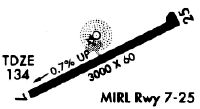
| Runways: | 07/25 |
| Longest Runway: | 07/25 is 3000 ft (914 m) long |
| Runways with an Instrument Approach: |
DLL Airport Runway Details
| Runway 07/25 | 3000 ft x 60 ft (914 m x 18 m) | |
| Runway Length Source: | NGS as of 12/11/1997 | |
| Surface: | Asphalt - Fair condition - Aggregate friction seal coat | |
| Runway Edge Lights: | Medium Intensity | |
Runway Weight Bearing Capacity (in thousands of pounds) |
||
| Single Wheel Landing Gear: | 10.0 | |
Runway 07 |
Runway 25 |
|
Elevation: |
133.1 | 117.3 |
Latitude: |
34-26-50.0740N | 34-27-03.1020N |
Longitude: |
079-22-23.0170W | 079-21-50.8320W |
|
Runway True Alignment: |
064 | 244 |
Glide Path Angle: |
0.0 degrees | 0.0 degrees |
Traffic Pattern: |
Left | Left |
Runway Markings Type: |
Nonprecision Instrument | Nonprecision Instrument |
Runway Markings Condition: |
Good | Good |
Object at End: |
POLE | TREE |
Object Height: |
44 | 50 |
Distance from End: |
773 | 276 |
Object Centerline Offset: |
258 ft. right of centerline | 135 ft. left of centerline |
Services
Airframe Repair: |
None |
Powerplant Repair: |
None |
Bottled Oxygen: |
None |
Bulk Oxygen: |
None |
Fuel Available: |
100LL, Jet A-1+ |
Landing Fees: |
No |
Parking: |
Tiedowns available |
Maps & Diagrams
DLL Sectional
Flight Planning
at skyvector.com
at skyvector.com