Location
Latitude: |
61-52-16.0250N (61.871118) |
Longitude: |
158-08-16.6430W (-158.137956) |
Elevation: |
177.2 feet MSL (54 m MSL) |
Magnetic Variation: |
11.4 E (as of April 2024 from WMM2020 model) |
Time Zone: |
UTC -9.0 (Standard Time) UTC -8.0 (Daylight Savings Time) |
From City: |
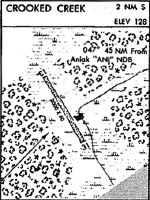
02 N.M. S of Crooked Creek, Alaska |
Found On: |
Mc Grath Chart |
FAA Region: |
AAL |
Contacts
Manager: |
Publicly owned: |
| ROXANNE EVAN BOX 584 ANIAK, AK 99557 907-675-4345 |
ALASKA DOT&PF CENTRAL REGION PO BOX 196900 ANCHORAGE, AK 99519-6900 907-269-0760 |
Operations
Airport Status: |
Operational |
Facility Use: |
Public |
Type: |
Airport |
Activation Date: |
07/1978 |
Control tower: |
No |
Attendance (Months/Days/Hours): |
Months/Days/Hours Unattended |
Boundary ARTCC: |
ZAN (Anchorage) |
Responsible ARTCC: |
ZAN (Anchorage) |
Segmented Circle Indicator: |
Yes |
Traffic Pattern Altitude (MSL): |
1177 feet (359 m) |
NOTAMs Facility: |
ENA |
NOTAM-D Service: |
Yes |
Military Landing Rights: |
Yes |
Based Aircraft
Annual Operations (as of 12/31/2022)
| Total Operations: | 500 | |
| Air Taxi: | 500 | 100.0% |
Communications
| CTAF: | 122.800 |
| AWOS-3PT: | 118.4 (907-269-2726) |
- APCH/DEP SVC PRVDD BY ANCHORAGE ARTCC (ZAN) ON FREQS 128.5/379.9 (SPARREVOHN RCAG).
Fixed Based Operators (FBOs) & Fuel
(Click on a business for detail)
Please help us keep this information up to date. This is a FREE SERVICE just like everything else on Airport Guide! If you see that a business needs to be added, modified, or deleted please fill out our Update Form.
To add, modify, or delete a business click here.
Please help us keep this information up to date. This is a FREE SERVICE just like everything else on Airport Guide! If you see that a business needs to be added, modified, or deleted please fill out our Update Form.
Area Code: 907 |
| Business Name | Frequency | Phone | Fuel Grade |
|---|---|---|---|
| Thomas Fishing Lodge & Trading Post
Website Update FBO info |
432-2240, 800-571-2959 | Mogas | |

|
 Independent |
MOGAS - 2.75 USD per gallon on 8/18/01 |
Pumps Fuel by prior arrangement only |
Flight Service Stations
| Primary | Alternate | |
| FSS on Field: | N | |
| FSS Name (ID): | Kenai(ENA) | |
| Frequency: | ||
| Toll Free Phone: | 1-866-864-1737 |
Instrument Procedures / Charts
FAA Terminal Procedures valid from 0901Z 03/21/24 to 0901Z 04/18/24.
There are various types of charts available for an airport. They are listed in the Page Type column. Here is a legend for those types:
APD - Airport Diagram
DP - Departure Procedure Charts
HOT - Hot Spots
IAP - Instrument Approach Procedure Charts
MIN - Minimums
STAR - Standard Terminal Arrival Charts
| Page Type | Page Name | Volume | Action Since Last Cycle |
|---|---|---|---|
| IAP | RNAV (GPS) RWY 14 | AK-1 | |
| MIN | TAKEOFF MINIMUMS | AK-1 | |
| ODP | AJOFY ONE (OBSTACLE) (RNAV) | AK-1 |
Terminal Procedures are only available for airports in several countries with more being added all the time. If you are looking for a specific country's charts, please send an email to support(at)airportguide.com stating the country name. This will be used to prioritize the implementation.
Navigation Aids (Navaids) near CKD
| Dist (NM) | ID | Morse Code | Name | Type | Freq | True Hdg | Mag Hdg |
|---|---|---|---|---|---|---|---|
| 44.8 | ANI | . _ _ . . . | Aniak | NDB | 359 | 248 | 237 |
| 73.5 | ANV | . _ _ . . . . _ | Anvik | NDB | 365 | 309 | 298 |
| 85.4 | SQA | . . . _ _ . _ . _ | Sparrevohn | VOR-DME | 117.20 | 121 | 109 |
| 86.9 | CRN | _ . _ . . _ . _ . | Cairn Mountain | NDB | 281 | 120 | 108 |
| 95.5 | MCG | _ _ _ . _ . _ _ . | Mc Grath | VORTAC | 115.50 | 46 | 34 |
| 96.5 | VTR | . . . _ _ . _ . | Takotna River | NDB | 350 | 46 | 34 |
Nearby Airports with Fuel
| Dist (NM) | Name (Airport IDs) | True Hdg | Mag Hdg | Fuel Grade |
|---|---|---|---|---|
| 43.6 | Aniak Airport (ANI PANI ANI) |
247 | 236 | 100LL, Jet A |
| 95.7 | Mc Grath Airport (MCG PAMC MCG) |
46 | 34 | 100LL, Jet A-1+ |
Notices to Airmen (NOTAMS)
Remarks
| A110-1 | RWY CONDITION NOT MONITORED; RCMD VISUAL INSPECTION PRIOR TO USING. |
| A30-14/32 | SLOPES DOWN TO SOUTH. NO LINE OF SIGHT BTN RWY ENDS. |
| A31-14/32 | RWY 32, FIRST 100 FT CLSD INDEFLY. |
Runways
Runway Summary
| Runways: | 14/32 |
| Longest Runway: | 14/32 is 3300 ft (1006 m) long |
| Runways with an Instrument Approach: |
CKD Airport Runway Details
| Runway 14/32 | 3300 ft x 75 ft (1006 m x 23 m) | |
| Runway Length Source: | 3RD PARTY SURVEY as of 05/22/2019 | |
| Surface: | Gravel - Excellent condition - No special surface treatment | |
Runway 14 |
Runway 32 |
|
Elevation: |
164.1 | 177.2 |
Latitude: |
61-52-30.7300N | 61-52-01.3200N |
Longitude: |
158-08-31.2600W | 158-08-02.0300W |
|
Runway True Alignment: |
155 | 335 |
Glide Path Angle: |
0.0 degrees | 0.0 degrees |
Traffic Pattern: |
Left | Left |
Runway Markings Type: |
None | None |
Runway Markings Condition: |
Poor | Poor |
REIL: |
Yes | Yes |
Services
Airframe Repair: |
Minor |
Powerplant Repair: |
Minor |
Fuel Available: |
100LL, Jet A-1+ |
Landing Fees: |
No |
Parking: |
Hangars and tiedowns available |
Maps & Diagrams
CKD Sectional
Flight Planning
at skyvector.com
at skyvector.com