
Location
Latitude: |
06-07-32.0514S (-6.12557) |
Longitude: |
106-39-21.5936E (106.655998) |
Elevation: |
34 feet MSL (10 m MSL) |
Magnetic Variation: |
0.5 E (as of April 2024 from WMM2020 model) |
Time Zone: |
UTC +7.0 (Standard Time) UTC +7.0 (Daylight Savings Time) |
Contacts
Manager: |
: |
Operations
Airport Status: |
Operational |
Facility Use: |
Public |
Type: |
Airport |
Traffic Pattern Altitude (MSL): |
1034 feet (315 m) |
Based Aircraft
Annual Operations (as of )
Communications
| JAKARTA CENTRAL INFO: | 129.7 |
| PABELOKAN INFO: | 129.8 |
| TWR: | 118.75 |
| CLNC DEL: | 121.95 |
| GND: | 121.6 |
| JAKARTA APP: | 119.75 |
| ATIS: | 126.85 |
| JAKARTA ARR: | 125.45 |
Fixed Based Operators (FBOs) & Fuel
(Click on a business for detail)
Please help us keep this information up to date. This is a FREE SERVICE just like everything else on Airport Guide! If you see that a business needs to be added, modified, or deleted please fill out our Update Form.
To add, modify, or delete a business click here.
Please help us keep this information up to date. This is a FREE SERVICE just like everything else on Airport Guide! If you see that a business needs to be added, modified, or deleted please fill out our Update Form.
| Business Name | Frequency | Phone | Fuel Grade |
|---|
Flight Service Stations
| Primary | Alternate | |
| FSS on Field: | ||
| FSS Name (ID): | ||
| Frequency: | ||
| Toll Free Phone: |
Instrument Procedures / Charts
Terminal Procedures are only available for airports in several countries with more being added all the time. If you are looking for a specific country's charts, please send an email to support(at)airportguide.com stating the country name. This will be used to prioritize the implementation.
Navigation Aids (Navaids) near CGK
| Dist (NM) | ID | Morse Code | Name | Type | Freq | True Hdg | Mag Hdg |
|---|---|---|---|---|---|---|---|
| 8.4 | CKG | Cengkareng | VOR-DME | 113.60 | 243 | 243 | |
| 10.9 | BTO | Budiarto | VOR-DME | 115.80 | 203 | 203 | |
| 11.2 | TN | Tangerang | NDB | 400 | 207 | 207 | |
| 15.0 | CB | Pondok Cabe | NDB | 225 | 153 | 153 | |
| 16.3 | HLM | Halim Perdanakusuma | VOR-DME | 113.30 | 122 | 122 | |
| 23.3 | AL | Halim Perdanakusuma | NDB | 215 | 100 | 100 | |
| 24.7 | DKI | Jakarta | VOR-DME | 114.60 | 66 | 66 | |
| 25.5 | AS | Atang Senjaya | NDB | 399 | 166 | 166 | |
| 54.2 | PW | Purwakarta | NDB | 250 | 119 | 119 | |
| 68.3 | BND | Bandung | VOR-DME | 117.00 | 131 | 131 | |
| 76.1 | OY | Bandung | NDB | 300 | 129 | 128 |
Nearby Airports with Fuel
| Dist (NM) | Name (Airport IDs) | True Hdg | Mag Hdg | Fuel Grade |
|---|
Notices to Airmen (NOTAMS)
Remarks
No remarks for this landing facility
Runways
Runway Summary
| Runways: | 06/24 07L/25R 07R/25L |
| Longest Runway: | 07R/25L is 12008 ft (3660 m) long |
| Runways with an Instrument Approach: |
CGK Airport Runway Details
| Runway 06/24 | 9843 ft x 197 ft (3000 m x 60 m) | |
| Runway Edge Lights: | Yes Intensity | |
Runway 06 |
Runway 24 |
|
Elevation: |
24 | 24 |
Latitude: |
-6.11388587951 | -6.10384178161 |
Longitude: |
106.64459228515 | 106.66976928710 |
Glide Path Angle: |
0.0 degrees | 0.0 degrees |
REIL: |
Yes | Yes |
Threshold Elevation: |
24 | 24 |
| Runway 07L/25R | 11812 ft x 197 ft (3600 m x 60 m) | |
| Runway Edge Lights: | Yes Intensity | |
Runway 07L |
Runway 25R |
|
Elevation: |
29 | 21 |
Latitude: |
-6.12105989456 | -6.10899019241 |
Longitude: |
106.63899993896 | 106.66899871826 |
|
Runway True Alignment: |
68.3 | 248.3 |
Glide Path Angle: |
0.0 degrees | 0.0 degrees |
REIL: |
Yes | Yes |
Threshold Elevation: |
29 | 21 |
| Runway 07R/25L | 12008 ft x 197 ft (3660 m x 60 m) | |
| Runway Edge Lights: | Yes Intensity | |
Runway 07R |
Runway 25L |
|
Elevation: |
34 | 27 |
Latitude: |
-6.14260005950 | -6.13032007217 |
Longitude: |
106.64399719238 | 106.67400360107 |
|
Runway True Alignment: |
68.3 | 248.3 |
Glide Path Angle: |
0.0 degrees | 0.0 degrees |
REIL: |
Yes | Yes |
Threshold Elevation: |
34 | 27 |
Services
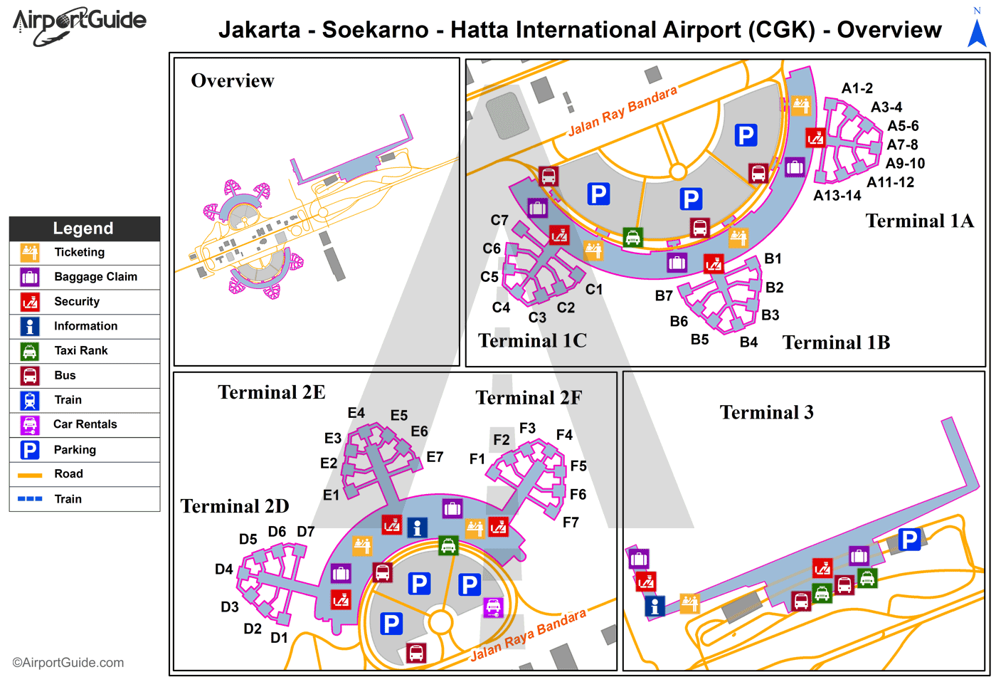
Maps & Diagrams
CGK Sectional
Flight Planning
at skyvector.com
at skyvector.com
