Location
Latitude: |
41-33-52.5000N (41.564583) |
Longitude: |
081-29-14.0000W (-81.487222) |
Elevation: |
876.1 feet MSL (267 m MSL) |
Magnetic Variation: |
8.5 W (as of April 2024 from WMM2020 model) |
Time Zone: |
UTC -5.0 (Standard Time) UTC -4.0 (Daylight Savings Time) |
From City: |
10 N.M. E of Cleveland, Ohio |
Found On: |
Detroit Chart |
FAA Region: |
AGL |
Contacts
Manager: |
Publicly owned: |
| J MYERS 26300 CURTISS WRIGHT PKWY RICHMOND HEIGHTS, OH 44143-4408 216-289-4111 |
CUYAHOGA COUNTY 26300 CURTISS WRIGHT PKWY RICHMOND HEIGHTS, OH 44143-4408 216-289-4111 |
Operations
Airport Status: |
Operational |
Facility Use: |
Public |
Type: |
Airport |
Activation Date: |
06/1950 |
Control tower: |
Yes |
Attendance (Months/Days/Hours): |
Months/Days/Hours ALL/ALL/0600-2300 |
Boundary ARTCC: |
ZOB (Cleveland) |
Responsible ARTCC: |
ZOB (Cleveland) |
Lighting Schedule: |
SEE RMK |
Segmented Circle Indicator: |
No |
Traffic Pattern Altitude (MSL): |
1876 feet (572 m) |
NOTAMs Facility: |
CGF |
NOTAM-D Service: |
Yes |
International Airport of Entry: |
No |
Customs Landing Rights: |
No |
Military Landing Rights: |
Yes |
Civil/Military Joint Use: |
No |
Based Aircraft
| Single Engine: | 59 |
| Multi Engine: | 18 |
| Jet Engine: | 169 |
| GA Helicopters: | 1 |
Annual Operations (as of 12/31/2020)
| Total Operations: | 22835 | |
| Air Taxi: | 4839 | 21.2% |
| GA Local: | 8320 | 36.4% |
| GA Itinerant: | 9663 | 42.3% |
| Military Aircraft: | 13 | 0.1% |
Communications
| CTAF: | 118.500 |
| Tower: | COUNTY 118.5 Hrs: 0700-2300 |
| Clearance Del.: | 121.85 ;WHEN TWR CLSD 121.85 ;WHEN TWR CLSD 121.85 ;WHEN TWR CLSD 121.85 ;WHEN TWR CLSD 121.85 ;WHEN TWR CLSD 121.85 ;WHEN TWR CLSD 121.85 ;WHEN TWR CLSD |
| Ground: | 121.85 |
| Approach: | CLEVELAND |
| Departure: | CLEVELAND |
| ATIS: | 119.95 Hrs: 24 |
| AWOS-3PT: | (216-289-4113) |
- ATCT IS CONTRACTED.
- EMRG FREQ 121.5 UNMONITORED.
Fixed Based Operators (FBOs) & Fuel
(Click on a business for detail)
Please help us keep this information up to date. This is a FREE SERVICE just like everything else on Airport Guide! If you see that a business needs to be added, modified, or deleted please fill out our Update Form.
To add, modify, or delete a business click here.
Please help us keep this information up to date. This is a FREE SERVICE just like everything else on Airport Guide! If you see that a business needs to be added, modified, or deleted please fill out our Update Form.
Area Code: 216 |
| Business Name | Frequency | Phone | Fuel Grade |
|---|---|---|---|
| Beckett Enterprises, Inc.
Update FBO info |
Unicom 122.95 | 261-1111 | 100LL, Jet A |
| Corporate Wings
Update FBO info |
261-5900 | 100LL, Jet A |
Flight Service Stations
| Primary | Alternate | |
| FSS on Field: | N | |
| FSS Name (ID): | Cleveland(CLE) | |
| Frequency: | ||
| Toll Free Phone: | 1-800-WX-BRIEF |
Instrument Procedures / Charts
FAA Terminal Procedures valid from 0901Z 03/21/24 to 0901Z 04/18/24.
There are various types of charts available for an airport. They are listed in the Page Type column. Here is a legend for those types:
APD - Airport Diagram
DP - Departure Procedure Charts
HOT - Hot Spots
IAP - Instrument Approach Procedure Charts
MIN - Minimums
STAR - Standard Terminal Arrival Charts
| Page Type | Page Name | Volume | Action Since Last Cycle |
|---|---|---|---|
| APD | AIRPORT DIAGRAM | EC-2 | |
| DP | AHMET FOUR (RNAV) | EC-2 | |
| DP | CAVVS FOUR (RNAV) | EC-2 | |
| DP | GTLKE FOUR (RNAV) | EC-2 | |
| DP | MYCAR FOUR (RNAV) | EC-2 | |
| DP | ZAAPA FIVE (RNAV) | EC-2 | |
| IAP | ILS OR LOC RWY 24 | EC-2 | |
| IAP | RNAV (GPS) RWY 06 | EC-2 | |
| IAP | RNAV (GPS) RWY 24 | EC-2 | |
| MIN | ALTERNATE MINIMUMS | EC-2 | |
| MIN | TAKEOFF MINIMUMS | EC-2 | |
| STAR | BRWNZ FOUR (RNAV) | EC-2 | |
| STAR | BRWNZ FOUR (RNAV)[DELIMITER] CONT.1 | EC-2 | |
| STAR | BRWNZ FOUR (RNAV)[DELIMITER] CONT.2 | EC-2 | |
| STAR | ROKNN THREE (RNAV) | EC-2 | |
| STAR | ROKNN THREE (RNAV)[DELIMITER] CONT.1 | EC-2 | |
| STAR | ROLLN TWO (RNAV) | EC-2 | |
| STAR | TRYBE FOUR (RNAV) | EC-2 | |
| STAR | TRYBE FOUR (RNAV)[DELIMITER] CONT.1 | EC-2 |
Terminal Procedures are only available for airports in several countries with more being added all the time. If you are looking for a specific country's charts, please send an email to support(at)airportguide.com stating the country name. This will be used to prioritize the implementation.
Navigation Aids (Navaids) near CGF
| Dist (NM) | ID | Morse Code | Name | Type | Freq | True Hdg | Mag Hdg |
|---|---|---|---|---|---|---|---|
| 8.6 | LQL | . _ . . _ _ . _ . _ . . | Lakeland | NDB | 263 | 34 | 43 |
| 14.8 | CXR | _ . _ . _ . . _ . _ . | Chardon | VOR-DME | 112.70 | 101 | 110 |
| 18.5 | CLE | _ . _ . . _ . . . | Cleveland | VOT | 110.40 | 241 | 249 |
| 30.0 | AK | . _ _ . _ | Akron | NDB | 362 | 171 | 180 |
| 30.3 | ACO | . _ _ . _ . _ _ _ | Akron | VOR-DME | 114.40 | 154 | 163 |
| 32.8 | DJB | _ . . . _ _ _ _ . . . | Dryer | VOR-DME | 113.60 | 248 | 256 |
| 35.1 | JFN | . _ _ _ . . _ . _ . | Jefferson | DME | 115.2 | 70 | 79 |
| 39.0 | CAK | _ . _ . . _ _ . _ | Akron/Canton Regional | VOT | 110.60 | 176 | 184 |
| 39.1 | YNG | _ . _ _ _ . _ _ . | Youngstown | VORTAC | 109.00 | 110 | 119 |
| 45.7 | YN | _ . _ _ _ . | Fetch | NDB | 338 | 118 | 127 |
| 49.5 | BSV | _ . . . . . . . . . _ | Briggs | VOR-DME | 112.40 | 177 | 185 |
| 49.6 | HBD | . . . . _ . . . _ . . | Hubbard | NDB | 408 | 119 | 128 |
| 50.0 | AAU | . _ . _ . . _ | Ashland | NDB | 329 | 224 | 232 |
| 52.0 | 4L | Chatham | NDB | 236 | 329 | 337 | |
| 53.0 | SKY | . . . _ . _ _ . _ _ | Sandusky | VOR-DME | 109.20 | 261 | 269 |
| 58.2 | UCP | . . _ _ . _ . . _ _ . | Castle | NDB | 272 | 123 | 132 |
| 59.9 | ERI | . . _ . . . | Erie | TACAN | 109.40 | 62 | 71 |
| 62.0 | ERI | . . _ . . . | Esmer | NDB | 349 | 62 | 71 |
| 62.1 | PCW | . _ _ . _ . _ . . _ _ | Port Clinton | NDB | 423 | 267 | 275 |
| 63.8 | MLR | _ _ . _ . . . _ . | Millersburg/Dcmsnd | NDB | 382 | 195 | 203 |
Nearby Airports with Fuel
Notices to Airmen (NOTAMS)
Remarks
| A110-10 | NOISE ABATEMENT PROCS IN EFCT CALL ARPT. |
| A110-11 | FOR CD WHEN ATCT CLSD CTC CLEVELAND APCH AT 216-352-2323. |
| A110-3 | BIRDS & WILDLIFE ON & INVOF ARPT. |
| A110-5 | ATCT VIS SW LTD WI 500 FT AER 06. |
| A110-9 | FLT TRG PROHIBITED 2300-0700. |
| A14 | CCAIRPORT@CUYAHOGACOUNTY.US. |
| A17 | FOR AFT HRS SVC CALL 216-261-8800 DRG ATNDD HRS. |
| A52-06 | 7 FT ROAD, 703 FT DIST, 325 FT L. |
| A57-06 | APCH SLP 10:1 TO DTHR OVR 84 FT TREES, 920 FT DIST, 620 FT R. |
| A57-24 | APCH SLP 6:1 TO DTHR OVR 20 FT TREES, 130 FT DIST, 500 FT R. |
| A58-24 | 7 FT ROAD, 0 FT DIST, 525 FT L; 2 FT FENCE, 0 FT DIST, 500 FT L. |
| A81-APT | WHEN ATCT CLSD ACTVT MALSR RWY 24; REIL RWY 06; PAPI RWY 06; HIRL RWY 06/24; WINDSOCKS - CTAF. PAPI RWY 24 OPR CONSLY. |
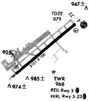
Runways
Runway Summary
| Runways: | 06/24 |
| Longest Runway: | 06/24 is 5502 ft (1677 m) long |
| Runways with an Instrument Approach: | 24 |
CGF Airport Runway Details
| Runway 06/24 | 5502 ft x 100 ft (1677 m x 30 m) | |
| Runway Length Source: | 3RD PARTY SURVEY as of 04/17/2017 | |
| Surface: | Asphalt - Good condition - Saw-cut or plastic grooved | |
| Runway Pavement Class: | 35 /F/C/X/U | |
| Runway Edge Lights: | High Intensity | |
Runway Weight Bearing Capacity (in thousands of pounds) |
||
| Single Wheel Landing Gear: | 90.0 | |
| Dual Wheel Landing Gear: | 123.0 | |
| Dual Tandem Wheel Landing Gear: | 213.0 | |
Runway 06 |
Runway 24 |
|
Elevation: |
876.1 | 874.0 |
Latitude: |
41-33-34.7913N | 41-34-10.1075N |
Longitude: |
081-29-41.4962W | 081-28-46.4732W |
|
Runway True Alignment: |
049 | 229 |
ILS Type: |
ILS/DME | |
Glide Path Angle: |
3.0 degrees | 3.0 degrees |
Traffic Pattern: |
Left | Left |
Runway Markings Type: |
Nonprecision Instrument | Precision Instrument |
Runway Markings Condition: |
Good | Good |
Arresting Device: |
EMAS | EMAS |
Object at End: |
TREE | ROAD |
Object Height: |
100 | 7 |
Distance from End: |
1418 | 201 |
Object Centerline Offset: |
500 ft. right of centerline | 325 ft. left of centerline |
Visual Glide Slope Indicators: |
4-Light PAPI On Left Side Of Runway | 4-Light PAPI On Left Side Of Runway |
Approach Light System: |
1,400 Foot Medium Intensity Approach Lighting System With Runway Alignment Indicator Lights | |
REIL: |
Yes | No |
Touchdown Lights: |
No | No |
Centerline Lights: |
No | No |
Threshold Crossing Height: |
45 | 45 |
Threshold Elevation: |
874.2 | 873.2 |
Displaced Threshold: |
318 | 500 |
Threshold Latitude: |
41-33-36.8300N | 41-34-06.8900N |
Threshold Longitude: |
081-29-38.3200W | 081-28-51.4900W |
Declared Distances |
||
Take Off Run Avbl. (TORA): |
5502 | 5502 |
Take Off Distance Avbl. (TODA): |
5502 | 5502 |
Actual Stop Dist. Avbl. (ASDA): |
5502 | 5502 |
Landing Dist. Avbl. (LDA): |
5184 | 5000 |
Services
Airframe Repair: |
None |
Powerplant Repair: |
None |
Bottled Oxygen: |
None |
Bulk Oxygen: |
None |
Fuel Available: |
100LL |
Landing Fees: |
No |
Parking: |
Hangars and tiedowns available |
Maps & Diagrams
CGF Sectional
Flight Planning
at skyvector.com
at skyvector.com