Location
Latitude: |
41-13-48.6100N (41.230169) |
Longitude: |
087-30-27.7000W (-87.507694) |
Elevation: |
671.8 feet MSL (205 m MSL) |
Magnetic Variation: |
4.2 W (as of April 2024 from WMM2020 model) |
Time Zone: |
UTC -6.0 (Standard Time) UTC -5.0 (Daylight Savings Time) |
From City: |
05 N.M. SW of Lowell, Indiana |
Found On: |
Chicago Chart |
FAA Region: |
AGL |
Contacts
Manager: |
Privately owned: |
| KEVIN BAILEY 14705 BELSHAW RD LOWELL, IN 46356 (219) 614-6633 |
DONALD E. BAILEY 14705 BELSHAW RD. LOWELL, IN 46356 (219) 614-6633 |
Operations
Airport Status: |
Operational |
Facility Use: |
Public |
Type: |
Airport |
Activation Date: |
08/1980 |
Control tower: |
No |
Attendance (Months/Days/Hours): |
Months/Days/Hours IREG |
Boundary ARTCC: |
ZAU (Chicago) |
Responsible ARTCC: |
ZAU (Chicago) |
Segmented Circle Indicator: |
Yes |
Traffic Pattern Altitude (MSL): |
1672 feet (510 m) |
NOTAMs Facility: |
HUF |
NOTAM-D Service: |
Yes |
Based Aircraft
| Single Engine: | 11 |
Annual Operations (as of 12/31/2019)
| Total Operations: | 1950 | |
| GA Local: | 1850 | 94.9% |
| GA Itinerant: | 100 | 5.1% |
Communications
| CTAF: | 122.900 |
- APCH/DEP SVC PRVDD BY CHICAGO ARTCC (ZAU) ON FREQS 132.5/284.7 (KANKAKEE RCAG).
Fixed Based Operators (FBOs) & Fuel
(Click on a business for detail)
Please help us keep this information up to date. This is a FREE SERVICE just like everything else on Airport Guide! If you see that a business needs to be added, modified, or deleted please fill out our Update Form.
To add, modify, or delete a business click here.
Please help us keep this information up to date. This is a FREE SERVICE just like everything else on Airport Guide! If you see that a business needs to be added, modified, or deleted please fill out our Update Form.
Area Code: 219 |
| Business Name | Frequency | Phone | Fuel Grade |
|---|---|---|---|
| Lowell Aviation, Inc.
Update FBO info |
696-9603 | 80, 100LL |
Flight Service Stations
| Primary | Alternate | |
| FSS on Field: | N | |
| FSS Name (ID): | Terre Haute(HUF) | |
| Frequency: | ||
| Toll Free Phone: | 1-800-WX-BRIEF |
Instrument Procedures / Charts
| Page Type | Page Name | Volume | Action Since Last Cycle |
|---|
Terminal Procedures are only available for airports in several countries with more being added all the time. If you are looking for a specific country's charts, please send an email to support(at)airportguide.com stating the country name. This will be used to prioritize the implementation.
Navigation Aids (Navaids) near C97
| Dist (NM) | ID | Morse Code | Name | Type | Freq | True Hdg | Mag Hdg |
|---|---|---|---|---|---|---|---|
| 13.0 | EON | . _ _ _ _ . | Peotone | VORTAC | 113.20 | 280 | 284 |
| 17.0 | CGT | _ . _ . _ _ . _ | Chicago Heights | VORTAC | 114.20 | 350 | 354 |
| 18.1 | IKK | . . _ . _ _ . _ | Kankakee | DME | 111.6 | 238 | 242 |
| 22.0 | IK | . . _ . _ | Lukow | NDB | 272 | 234 | 238 |
| 31.3 | VP | . . . _ . _ _ . | Sedly | NDB | 212 | 64 | 68 |
| 31.8 | MX | _ _ _ . . _ | Kedzi | NDB | 248 | 345 | 349 |
| 32.8 | HK | . . . . _ . _ | Ermin | NDB | 332 | 333 | 337 |
| 35.1 | MDW | _ _ _ . . . _ _ | Chicago Midway | VOT | 111.00 | 341 | 345 |
| 36.9 | IUL | . . . . _ . _ . . | La Porte | NDB | 356 | 63 | 67 |
| 39.1 | OXI | _ _ _ _ . . _ . . | Knox | DME | 115.6 | 81 | 86 |
| 41.1 | JOT | . _ _ _ _ _ _ _ | Joliet | VOR-DME | 112.30 | 297 | 301 |
| 41.6 | RWN | . _ . . _ _ _ . | Winamac/Dcmsnd | NDB | 335 | 101 | 106 |
| 45.1 | BVT | _ . . . . . . _ _ | Boiler | VORTAC | 115.10 | 153 | 157 |
| 48.8 | ORD | _ _ _ . _ . _ . . | Chicago O'hare | VOR-DME | 113.90 | 338 | 342 |
| 49.0 | RBS | . _ . _ . . . . . . | Roberts | VOR-DME | 116.80 | 217 | 221 |
| 49.1 | GCO | _ _ . _ . _ . _ _ _ | Chicago | DME | 108.25 | 339 | 343 |
| 50.0 | ME | _ _ . | Deana | NDB | 350 | 332 | 336 |
| 50.7 | CPB | _ . _ . . _ _ . _ . . . | Culver | NDB | 391 | 90 | 95 |
| 52.5 | LA | . _ . . . _ | Earle | NDB | 401 | 156 | 160 |
| 54.8 | DPA | _ . . . _ _ . . _ | Dupage | VOR-DME | 108.40 | 316 | 320 |
Nearby Airports with Fuel
Notices to Airmen (NOTAMS)
Remarks
| A110-2 | SNOW REMOVAL & MOWING WITH LARGE TRACTOR . |
| A110-3 | DEER ON & INVOF ARPT. |
| A110-5 | CALL FOR FUEL OR SVC BFR ARR - 219-613-4588. |
| A110-6 | FOR CD CTC CHICAGO ARTCC AT 630-906-8921. |
| A30-18/36 | CROPS 75 FT E & 87 FT W OF CNTRLN. |
| A42-18 | WHITE BARREL HALVES & LGT FIXTURES. |
| A42-36 | WHITE BARREL HALVES & LGT FIXTURES. |
| A57-18 | APCH SLOPE 15:1 FM DSPLCD THR; 65 FT TREE 985 FT & 110 FT R. |
| E111 | PRVDD ALL TFC PAT OPS ARE RSTRD TO W SIDE OF THE N/S RWY. |
Runways
Runway Summary
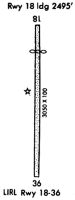
| Runways: | 18/36 |
| Longest Runway: | 18/36 is 3041 ft (927 m) long |
| Runways with an Instrument Approach: |
C97 Airport Runway Details
| Runway 18/36 | 3041 ft x 100 ft (927 m x 30 m) | |
| Runway Length Source: | ADO as of 08/13/2020 | |
| Surface: | Turf - Good condition - No special surface treatment | |
Runway 18 |
Runway 36 |
|
Elevation: |
671.8 | 650.0 |
Latitude: |
41-14-03.6300N | 41-13-33.5900N |
Longitude: |
087-30-27.7200W | 087-30-27.6800W |
|
Runway True Alignment: |
180 | 360 |
Glide Path Angle: |
0.0 degrees | 0.0 degrees |
Traffic Pattern: |
Right | Left |
Runway Markings Type: |
Nonstandard (other than numbers only) | Nonstandard (other than numbers only) |
Runway Markings Condition: |
Fair | Fair |
Object at End: |
CROPS | CROPS |
Object Height: |
10 | 10 |
Distance from End: |
0 | 0 |
Object Centerline Offset: |
0 ft. left and right of centerline | 0 ft. left and right of centerline |
Threshold Elevation: |
660.4 | |
Displaced Threshold: |
775 | |
Threshold Latitude: |
41-13-55.9700N | |
Threshold Longitude: |
087-30-27.7100W |
Services
Bottled Oxygen: |
None |
Bulk Oxygen: |
None |
Fuel Available: |
100LL, Mogas |
Landing Fees: |
No |
Parking: |
Tiedowns available |
Maps & Diagrams
C97 Sectional
Flight Planning
at skyvector.com
at skyvector.com