Location
Latitude: |
42-38-02.8540N (42.634126) |
Longitude: |
088-36-04.0650W (-88.601129) |
Elevation: |
981.0 feet MSL (299 m MSL) |
Magnetic Variation: |
3.5 W (as of April 2024 from WMM2020 model) |
Time Zone: |
UTC -6.0 (Standard Time) UTC -5.0 (Daylight Savings Time) |
From City: |
02 N.M. E of Delavan, Wisconsin |
Found On: |
Chicago Chart |
FAA Region: |
AGL |
Contacts
Manager: |
Privately owned: |
| DANIEL LYNG 2400 EAST GENEVA ST DELAVAN, WI 53115 (262) 725-9127 |
DELEVAN LAKE LAWN MANAGEMENT 2400 EAST GENEVA ST DELAVAN, WI 53115 262-728-7950 |
Operations
Airport Status: |
Operational |
Facility Use: |
Public |
Type: |
Airport |
Activation Date: |
04/1974 |
Control tower: |
No |
Attendance (Months/Days/Hours): |
Months/Days/Hours Unattended |
Boundary ARTCC: |
ZAU (Chicago) |
Responsible ARTCC: |
ZAU (Chicago) |
Segmented Circle Indicator: |
No |
Traffic Pattern Altitude (MSL): |
1981 feet (604 m) |
NOTAMs Facility: |
GRB |
NOTAM-D Service: |
Yes |
International Airport of Entry: |
No |
Customs Landing Rights: |
No |
Military Landing Rights: |
No |
Civil/Military Joint Use: |
No |
Based Aircraft
Annual Operations (as of 06/09/2023)
| Total Operations: | 1300 | |
| Air Taxi: | 25 | 1.9% |
| GA Local: | 250 | 19.2% |
| GA Itinerant: | 1000 | 76.9% |
| Military Aircraft: | 25 | 1.9% |
Communications
| CTAF: | 122.900 |
| Approach: | ROCKFORD 121.0 121.0 |
| Departure: | ROCKFORD 121.0 121.0 |
Fixed Based Operators (FBOs) & Fuel
(Click on a business for detail)
Please help us keep this information up to date. This is a FREE SERVICE just like everything else on Airport Guide! If you see that a business needs to be added, modified, or deleted please fill out our Update Form.
To add, modify, or delete a business click here.
Please help us keep this information up to date. This is a FREE SERVICE just like everything else on Airport Guide! If you see that a business needs to be added, modified, or deleted please fill out our Update Form.
Area Code: 262 |
| Business Name | Frequency | Phone | Fuel Grade |
|---|
Flight Service Stations
| Primary | Alternate | |
| FSS on Field: | N | |
| FSS Name (ID): | Green Bay(GRB) | |
| Frequency: | ||
| Toll Free Phone: | 1-800-WX-BRIEF |
Instrument Procedures / Charts
| Page Type | Page Name | Volume | Action Since Last Cycle |
|---|
Terminal Procedures are only available for airports in several countries with more being added all the time. If you are looking for a specific country's charts, please send an email to support(at)airportguide.com stating the country name. This will be used to prioritize the implementation.
Navigation Aids (Navaids) near C59
| Dist (NM) | ID | Morse Code | Name | Type | Freq | True Hdg | Mag Hdg |
|---|---|---|---|---|---|---|---|
| 3.9 | LVV | . _ . . . . . _ . . . _ | Lake Lawn | NDB | 404 | 5 | 9 |
| 13.6 | BUU | _ . . . . . _ . . _ | Burbun | DME | 114.5 | 75 | 79 |
| 19.5 | JVL | . _ _ _ . . . _ . _ . . | Janesville | NDB | 375 | 266 | 269 |
| 22.7 | JVL | . _ _ _ . . . _ . _ . . | Janesville | VOR-DME | 114.30 | 258 | 261 |
| 25.7 | EN | . _ . | Codee | NDB | 389 | 99 | 103 |
| 29.6 | ENW | . _ . . _ _ | Kenosha | DME | 109.2 | 93 | 97 |
| 29.7 | GM | _ _ . _ _ | Teels | NDB | 242 | 56 | 60 |
| 31.1 | RA | . _ . . _ | Paser | NDB | 206 | 84 | 88 |
| 32.1 | BAE | _ . . . . _ . | Badger | VOR-DME | 116.40 | 25 | 29 |
| 32.8 | RYV | . _ . _ . _ _ . . . _ | Rock River | NDB | 371 | 350 | 354 |
| 35.5 | HRK | . . . . . _ . _ . _ | Horlick | DME | 114.05 | 77 | 81 |
| 36.1 | RFD | . _ . . . _ . _ . . | Rockford | DME | 110.8 | 227 | 230 |
| 36.3 | MKE | _ _ _ . _ . | Milwaukee | VOT | 109.00 | 58 | 62 |
| 36.8 | UG | . . _ _ _ . | Wauke | NDB | 379 | 105 | 109 |
| 37.8 | LJT | . _ . . . _ _ _ _ | Timmerman | DME | 115.65 | 40 | 44 |
| 38.0 | OBK | _ _ _ _ . . . _ . _ | Northbrook | VOR-DME | 113.00 | 130 | 134 |
| 38.2 | RF | . _ . . . _ . | Gilmy | NDB | 275 | 215 | 218 |
| 40.8 | BL | _ . . . . _ . . | Yanks | NDB | 260 | 51 | 55 |
| 41.7 | MS | _ _ . . . | Monah | NDB | 400 | 308 | 311 |
| 44.6 | MSN | _ _ . . . _ . | Madison | VORTAC | 108.60 | 313 | 316 |
Nearby Airports with Fuel
Notices to Airmen (NOTAMS)
Remarks
| A110-5 | ARPT CLSD FOR NIGHT OPNS. |
| A110-6 | LOW WING ACFT AVOID SOUTH TWY, 25 FT FM TWY CENTERLINE TO 3 FT FENCE. |
| A110-7 | FOR CD CTC CHICAGO ARTCC AT 630-906-8921. |
| A42-18 | MARKINGS FADED. |
| A42-36 | MARKINGS FADED. |
| A57-18 | APCH RATIO 20:1 TO DSPLCD THR. |
| A57-36 | APCH RATIO 20:1 TO DSPLCD THR. |
| A58-18 | 4 FT FENCE 12 FT FM RWY END; RD 40 FT FM RWY END. |
| A58-36 | 4 FT FENCE 5 FT FM RWY END; RD 30 FT FM RWY END. |
| E111 | TFC PTN OPER TO W OF DELAVAN LAKE BTWN ARPT & TWIST ARPT 1 1/2 NM SE. |
Runways
Runway Summary
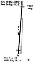
| Runways: | 18/36 |
| Longest Runway: | 18/36 is 4423 ft (1348 m) long |
| Runways with an Instrument Approach: |
C59 Airport Runway Details
| Runway 18/36 | 4423 ft x 80 ft (1348 m x 24 m) | |
| Surface: | Asphalt - Fair condition - No special surface treatment | |
Runway 18 |
Runway 36 |
|
Elevation: |
979.0 | 967.0 |
Latitude: |
42-38-24.6410N | 42-37-41.1120N |
Longitude: |
088-36-01.5470W | 088-36-06.5330W |
|
Runway True Alignment: |
185 | 005 |
Glide Path Angle: |
0.0 degrees | 0.0 degrees |
Traffic Pattern: |
Left | Left |
Runway Markings Type: |
Nonprecision Instrument | Nonprecision Instrument |
Runway Markings Condition: |
Poor | Poor |
Object at End: |
TREE | TREE |
Object Height: |
17 | 31 |
Distance from End: |
242 | 465 |
Object Centerline Offset: |
120 ft. right of centerline | 34 ft. right of centerline |
REIL: |
No | |
Touchdown Lights: |
No | No |
Centerline Lights: |
No | No |
Threshold Elevation: |
978.1 | 967.8 |
Displaced Threshold: |
320 | 300 |
Threshold Latitude: |
42-38-21.4910N | 42-37-44.0640N |
Threshold Longitude: |
088-36-01.9070W | 088-36-06.1950W |
Services
Airframe Repair: |
Major |
Powerplant Repair: |
Major |
Bottled Oxygen: |
None |
Bulk Oxygen: |
None |
Fuel Available: |
100LL, Jet A, MOGAS |
Landing Fees: |
Yes |
Parking: |
Hangars and tiedowns available |
Maps & Diagrams
C59 Sectional
Flight Planning
at skyvector.com
at skyvector.com