Location
Latitude: |
32-36-54.4000N (32.615111) |
Longitude: |
085-26-02.4000W (-85.434) |
Elevation: |
776.8 feet MSL (237 m MSL) |
Magnetic Variation: |
4.7 W (as of April 2024 from WMM2020 model) |
Time Zone: |
UTC -6.0 (Standard Time) UTC -5.0 (Daylight Savings Time) |
From City: |
02 N.M. E of Auburn, Alabama |
Found On: |
Atlanta Chart |
FAA Region: |
ASO |
Contacts
Manager: |
Publicly owned: |
| WILLIAM T. HUTTO 2150 BENT CREEK RD. AUBURN, AL 36830 334-844-4606 |
AUBURN UNIVERSITY 2150 BENT CREEK RD. AUBURN, AL 36830 334-844-4597 |
Operations
Airport Status: |
Operational |
Facility Use: |
Public |
Type: |
Airport |
Activation Date: |
03/1941 |
Control tower: |
No |
Attendance (Months/Days/Hours): |
Months/Days/Hours ALL/MON-FRI/0700-1900 |
Boundary ARTCC: |
ZTL (Atlanta) |
Responsible ARTCC: |
ZTL (Atlanta) |
Lighting Schedule: |
SEE RMK |
Segmented Circle Indicator: |
Yes |
Traffic Pattern Altitude (MSL): |
1777 feet (542 m) |
NOTAMs Facility: |
AUO |
NOTAM-D Service: |
Yes |
International Airport of Entry: |
No |
Customs Landing Rights: |
No |
Military Landing Rights: |
Yes |
Civil/Military Joint Use: |
No |
Based Aircraft
| Single Engine: | 93 |
| Multi Engine: | 22 |
| Jet Engine: | 4 |
Annual Operations (as of 12/31/2021)
| Total Operations: | 110422 | |
| Air Taxi: | 3882 | 3.5% |
| GA Local: | 77207 | 69.9% |
| GA Itinerant: | 29105 | 26.4% |
| Military Aircraft: | 228 | 0.2% |
Communications
| CTAF: | 123.000 |
| Unicom: | 123.000 |
| Clearance Del.: | 118.7 118.7 118.7 118.7 118.7 |
| Approach: | ATLANTA ATLANTA ARTCC |
| Departure: | ATLANTA ATLANTA ARTCC |
| AWOS-3PT: | 132.575 (334-501-0387) |
- APCH/DEP SVC PRVDD BY ATLANTA LARGE TRACON 125.5 (0515-2200) OTHER TIMES ATLANTA ARTCC 120.45/298.850 (COLUMBUS RCAG).
- CLNC DEL PRVDD BY ATLANTA LARGE TRACON 118.7 (0515-2200) OTHER TIMES ATLANTA ARTCC 120.45/298.850 (COLUMBUS RCAG).
Fixed Based Operators (FBOs) & Fuel
(Click on a business for detail)
Please help us keep this information up to date. This is a FREE SERVICE just like everything else on Airport Guide! If you see that a business needs to be added, modified, or deleted please fill out our Update Form.
To add, modify, or delete a business click here.
Please help us keep this information up to date. This is a FREE SERVICE just like everything else on Airport Guide! If you see that a business needs to be added, modified, or deleted please fill out our Update Form.
Area Code: 334 |
| Business Name | Frequency | Phone | Fuel Grade |
|---|---|---|---|
| Auburn University Aviation
Update FBO info |
Unicom 123.0 | 844-4597 | 100LL, Jet A |
Flight Service Stations
| Primary | Alternate | |
| FSS on Field: | N | |
| FSS Name (ID): | Anniston(ANB) | |
| Frequency: | ||
| Toll Free Phone: | 1-800-WX-BRIEF |
Instrument Procedures / Charts
FAA Terminal Procedures valid from 0901Z 03/21/24 to 0901Z 04/18/24.
There are various types of charts available for an airport. They are listed in the Page Type column. Here is a legend for those types:
APD - Airport Diagram
DP - Departure Procedure Charts
HOT - Hot Spots
IAP - Instrument Approach Procedure Charts
MIN - Minimums
STAR - Standard Terminal Arrival Charts
| Page Type | Page Name | Volume | Action Since Last Cycle |
|---|---|---|---|
| IAP | ILS OR LOC RWY 36 | SE-4 | |
| IAP | RNAV (GPS) RWY 11 | SE-4 | |
| IAP | RNAV (GPS) RWY 18 | SE-4 | |
| IAP | RNAV (GPS) RWY 29 | SE-4 | |
| IAP | RNAV (GPS) RWY 36 | SE-4 | |
| MIN | ALTERNATE MINIMUMS | SE-4 | |
| MIN | TAKEOFF MINIMUMS | SE-4 |
Terminal Procedures are only available for airports in several countries with more being added all the time. If you are looking for a specific country's charts, please send an email to support(at)airportguide.com stating the country name. This will be used to prioritize the implementation.
Navigation Aids (Navaids) near AUO
| Dist (NM) | ID | Morse Code | Name | Type | Freq | True Hdg | Mag Hdg |
|---|---|---|---|---|---|---|---|
| 14.2 | TGE | _ _ _ . . | Tuskegee | VOR-DME | 117.30 | 236 | 241 |
| 21.0 | CSG | _ . _ . . . . _ _ . | Columbus | TACAN | 117.10 | 89 | 94 |
| 22.1 | CS | _ . _ . . . . | Fenix | NDB | 355 | 116 | 121 |
| 28.0 | LSF | . _ . . . . . . . _ . | Lawson | VOR-DME | 111.40 | 127 | 132 |
| 28.4 | AWS | . _ . _ _ . . . | Lawson | NDB | 335 | 132 | 137 |
| 28.5 | LGC | . _ . . _ _ . _ . _ . | Lagrange | VORTAC | 115.60 | 23 | 28 |
| 31.0 | DER | _ . . . . _ . | Alexander City | NDB | 382 | 300 | 305 |
| 31.5 | PIM | . _ _ . . . _ _ | Pine Mountain | NDB | 272 | 64 | 69 |
| 42.8 | EUF | . . . _ . . _ . | Eufaula | VORTAC | 109.20 | 158 | 163 |
| 49.4 | MXF | _ _ _ . . _ . . _ . | Maxwell | TACAN | 115.00 | 253 | 257 |
| 50.7 | MGM | _ _ _ _ . _ _ | Montgomery | VORTAC | 112.10 | 242 | 246 |
| 52.9 | EQQ | . _ _ . _ _ _ . _ | Coweta County | NDB | 234 | 43 | 48 |
| 55.8 | SCD | . . . _ . _ . _ . . | Sylacauga | NDB | 284 | 307 | 311 |
| 57.5 | MG | _ _ _ _ . | Marra | NDB | 245 | 251 | 255 |
| 58.1 | TOI | _ _ _ _ . . | Blood | NDB | 365 | 216 | 220 |
| 59.0 | GPQ | _ _ . . _ _ . _ _ . _ | Carrollton | NDB | 278 | 14 | 19 |
| 60.6 | AN | . _ _ . | Bogga | NDB | 211 | 335 | 340 |
| 61.1 | GGY | _ _ . _ _ . _ . _ _ | Gragg-Wade | NDB | 338 | 283 | 287 |
| 63.0 | FFC | . . _ . . . _ . _ . _ . | Pecat | NDB | 316 | 48 | 53 |
| 65.2 | TDG | _ _ . . _ _ . | Talladega | DME | 108.8 | 332 | 337 |
Nearby Airports with Fuel
Notices to Airmen (NOTAMS)
Remarks
| A110-1 | JET START CPBLTY AVBL. |
| A110-2 | TMPRY ATCT BY NOTAM FOR SPL EVENTS. |
| A110-5 | SAWRS WX AVBL ON REQ. |
| A110-6 | HVY FLT STUDENT ACTVTY WI 35NM OF ARPT. |
| A57-29 | APCH RATIO 26:1 FROM DSPLCD THLD. |
| A70-FUEL-10 | 0LL SVC AFT HRS & HOL 334-501-3100. |
| A81-APT | ACTVT MALSF RWY 36; PAPI RWY 29 & 36; MIRL RWY 11/29; HIRL RWY 18/36 - CTAF |
| E111 | ARPT PRECEDED ACT ANLYS NOT REQD. |
Runways
Runway Summary
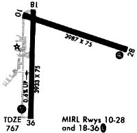
| Runways: | 11/29 18/36 |
| Longest Runway: | 18/36 is 5264 ft (1604 m) long |
| Runways with an Instrument Approach: | 36 |
AUO Airport Runway Details
| Runway 11/29 | 4000 ft x 75 ft (1219 m x 23 m) | |
| Runway Length Source: | 3RD PARTY SURVEY as of 05/22/2006 | |
| Surface: | Asphalt - Excellent condition - No special surface treatment | |
| Runway Edge Lights: | Medium Intensity | |
Runway Weight Bearing Capacity (in thousands of pounds) |
||
| Single Wheel Landing Gear: | 25.0 | |
| Dual Wheel Landing Gear: | 42.0 | |
Runway 11 |
Runway 29 |
|
Elevation: |
774.9 | 766.3 |
Latitude: |
32-37-10.4919N | 32-36-58.7148N |
Longitude: |
085-26-14.4647W | 085-25-29.8200W |
|
Runway True Alignment: |
107 | 287 |
Glide Path Angle: |
0.0 degrees | 3.0 degrees |
Traffic Pattern: |
Left | Left |
Runway Markings Type: |
Nonprecision Instrument | Nonprecision Instrument |
Runway Markings Condition: |
Fair | Fair |
Object at End: |
TREES | TREE |
Object Height: |
17 | 30 |
Distance from End: |
373 | 490 |
Object Centerline Offset: |
191 ft. left of centerline | 14 ft. left of centerline |
Visual Glide Slope Indicators: |
4-Light PAPI On Left Side Of Runway | |
Threshold Crossing Height: |
22 | |
Threshold Elevation: |
764.4 | |
Displaced Threshold: |
297 | |
Threshold Latitude: |
32-36-59.5906N | |
Threshold Longitude: |
085-25-33.1380W |
| Runway 18/36 | 5264 ft x 100 ft (1604 m x 30 m) | |
| Runway Length Source: | 3RD PARTY SURVEY as of 05/22/2006 | |
| Surface: | Asphalt - Excellent condition - Saw-cut or plastic grooved | |
| Runway Edge Lights: | High Intensity | |
Runway Weight Bearing Capacity (in thousands of pounds) |
||
| Single Wheel Landing Gear: | 45.0 | |
| Dual Wheel Landing Gear: | 75.0 | |
Runway 18 |
Runway 36 |
|
Elevation: |
776.8 | 731.1 |
Latitude: |
32-37-12.7247N | 32-36-20.6524N |
Longitude: |
085-26-09.7285W | 085-26-10.8443W |
|
Runway True Alignment: |
181 | 001 |
ILS Type: |
ILS/DME | |
Glide Path Angle: |
0.0 degrees | 3.0 degrees |
Traffic Pattern: |
Left | Left |
Runway Markings Type: |
Precision Instrument | Precision Instrument |
Runway Markings Condition: |
Good | Good |
Object at End: |
TREE | TREE |
Object Height: |
15 | 35 |
Distance from End: |
411 | 1560 |
Object Centerline Offset: |
191 ft. left of centerline | 14 ft. left of centerline |
Visual Glide Slope Indicators: |
4-Light PAPI On Left Side Of Runway | |
Approach Light System: |
1,400 Foot Medium Intensity Approach Lighting System With Sequenced Flashers | |
Touchdown Lights: |
No | No |
Threshold Crossing Height: |
44 |
Services
Airframe Repair: |
Major |
Powerplant Repair: |
Major |
Bottled Oxygen: |
None |
Bulk Oxygen: |
None |
Fuel Available: |
100LL, Jet A |
Landing Fees: |
No |
Parking: |
Tiedowns available |
Maps & Diagrams

AUO Sectional
Flight Planning
at skyvector.com
at skyvector.com