Location
Latitude: |
38-53-23.7000N (38.889917) |
Longitude: |
090-02-45.6000W (-90.046) |
Elevation: |
543.5 feet MSL (166 m MSL) |
Magnetic Variation: |
2.1 W (as of April 2024 from WMM2020 model) |
Time Zone: |
UTC -6.0 (Standard Time) UTC -5.0 (Daylight Savings Time) |
From City: |
04 N.M. E of Alton/St. Louis, Illinois |
Found On: |
St Louis Chart |
FAA Region: |
AGL |
Contacts
Manager: |
Publicly owned: |
| DANIEL ADAMS, AAE 8 TERMINAL DR, SUITE 1 EAST ALTON, IL 62024 618-259-2531 |
ST. LOUIS REGIONAL 8 TERMINAL DR SUITE 1 EAST ALTON, IL 62024 618-259-2531 |
Operations
Airport Status: |
Operational |
Facility Use: |
Public |
Type: |
Airport |
Activation Date: |
04/1940 |
Control tower: |
Yes |
Attendance (Months/Days/Hours): |
Months/Days/Hours ALL/ALL/0700-2200 |
Boundary ARTCC: |
ZKC (Kansas City) |
Responsible ARTCC: |
ZKC (Kansas City) |
Lighting Schedule: |
SEE RMK |
Segmented Circle Indicator: |
No |
Traffic Pattern Altitude (MSL): |
1544 feet (471 m) |
NOTAMs Facility: |
ALN |
NOTAM-D Service: |
Yes |
International Airport of Entry: |
No |
Customs Landing Rights: |
No |
Military Landing Rights: |
Yes |
Civil/Military Joint Use: |
No |
Aircraft Rescue and Firefighting: |
Class IV ARFF Index: A Air Carrier Service: Not Scheduled Certification Date: 10/1974 |
Based Aircraft
| Single Engine: | 68 |
| Multi Engine: | 5 |
| Jet Engine: | 4 |
Annual Operations (as of 11/30/2018)
| Total Operations: | 29450 | |
| Commercial: | 16 | 0.1% |
| Air Taxi: | 3943 | 13.4% |
| GA Local: | 14040 | 47.7% |
| GA Itinerant: | 10809 | 36.7% |
| Military Aircraft: | 642 | 2.2% |
Communications
| CTAF: | 126.000 |
| Unicom: | 122.950 |
| Tower: | REGIONAL 126.0 239.0 Hrs: 0700-2200 |
| Ground: | 120.2 |
| Approach: | SAINT LOUIS |
| Departure: | SAINT LOUIS |
| ATIS: | 128.0 Hrs: 24 |
| AWOS-3: | 128.0 (618-259-7231) |
- ATCT OPERATED BY CONTRACT WITH MIDWEST ATC SERVICES INC.
Fixed Based Operators (FBOs) & Fuel
(Click on a business for detail)
Please help us keep this information up to date. This is a FREE SERVICE just like everything else on Airport Guide! If you see that a business needs to be added, modified, or deleted please fill out our Update Form.
To add, modify, or delete a business click here.
Please help us keep this information up to date. This is a FREE SERVICE just like everything else on Airport Guide! If you see that a business needs to be added, modified, or deleted please fill out our Update Form.
Area Code: 618 |
| Business Name | Frequency | Phone | Fuel Grade |
|---|---|---|---|
| Langa Air, Inc.
Update FBO info |
Unicom 122.95 | 800-624-9068, 258-1005 | 80, 100LL, Jet A |
| Premier Air Center, Inc.
Update FBO info |
Unicom 122.95, Arinc 130.6 | 800-851-5026, 259-3230 | 100LL, Jet A |
Flight Service Stations
| Primary | Alternate | |
| FSS on Field: | N | |
| FSS Name (ID): | Saint Louis(STL) | |
| Frequency: | ||
| Toll Free Phone: | 1-800-WX-BRIEF |
Instrument Procedures / Charts
FAA Terminal Procedures valid from 0901Z 03/21/24 to 0901Z 04/18/24.
There are various types of charts available for an airport. They are listed in the Page Type column. Here is a legend for those types:
APD - Airport Diagram
DP - Departure Procedure Charts
HOT - Hot Spots
IAP - Instrument Approach Procedure Charts
MIN - Minimums
STAR - Standard Terminal Arrival Charts
| Page Type | Page Name | Volume | Action Since Last Cycle |
|---|---|---|---|
| APD | AIRPORT DIAGRAM | EC-3 | |
| DP | GATEWAY ONE | EC-3 | |
| DP | GATEWAY ONE[DELIMITER] CONT.1 | EC-3 | |
| DP | LINDBERGH EIGHT | EC-3 | |
| DP | LINDBERGH EIGHT[DELIMITER] CONT.1 | EC-3 | |
| DP | OZARK EIGHT | EC-3 | |
| DP | PLESS FIVE | EC-3 | |
| HOT | HOT SPOT | EC-3 | |
| IAP | ILS OR LOC RWY 29 | EC-3 | |
| IAP | RNAV (GPS) RWY 11 | EC-3 | |
| IAP | RNAV (GPS) RWY 17 | EC-3 | |
| IAP | RNAV (GPS) RWY 29 | EC-3 | |
| IAP | RNAV (GPS) RWY 35 | EC-3 | |
| IAP | VOR-A | EC-3 | |
| LAH | LAHSO | EC-3 | |
| MIN | ALTERNATE MINIMUMS | EC-3 | |
| MIN | TAKEOFF MINIMUMS | EC-3 | |
| STAR | DELMA FOUR (RNAV) | EC-3 | |
| STAR | FARMR THREE (RNAV) | EC-3 |
Terminal Procedures are only available for airports in several countries with more being added all the time. If you are looking for a specific country's charts, please send an email to support(at)airportguide.com stating the country name. This will be used to prioritize the implementation.
Navigation Aids (Navaids) near ALN
| Dist (NM) | ID | Morse Code | Name | Type | Freq | True Hdg | Mag Hdg |
|---|---|---|---|---|---|---|---|
| 0.5 | CVM | _ . _ . . . . _ _ _ | Civic Memorial | NDB | 263 | 286 | 288 |
| 5.5 | AL | . _ . _ . . | Alpos | NDB | 218 | 112 | 114 |
| 10.8 | TOY | _ _ _ _ _ . _ _ | Troy | VORTAC | 116.00 | 146 | 148 |
| 12.5 | ST | . . . _ | Zumay | NDB | 404 | 240 | 242 |
| 16.9 | CSX | _ . _ . . . . _ . . _ | Cardinal | DME | 116.45 | 240 | 242 |
| 17.4 | STL | . . . _ . _ . . | St Louis Lambert | VOT | 111.00 | 239 | 241 |
| 20.5 | STL | . . . _ . _ . . | St Louis | VORTAC | 117.40 | 265 | 267 |
| 20.7 | LM | . _ . . _ _ | Oblio | NDB | 338 | 255 | 257 |
| 22.2 | CP | _ . _ . . _ _ . | Acore | NDB | 350 | 181 | 183 |
| 22.6 | SKE | . . . _ . _ . | Scott | TACAN | 112.20 | 156 | 158 |
| 26.7 | FZ | . . _ . _ _ . . | Eaves | NDB | 227 | 241 | 243 |
| 28.6 | JD | . _ _ _ _ . . | Gooey | NDB | 385 | 149 | 151 |
| 28.9 | BL | _ . . . . _ . . | Belleville | NDB | 362 | 151 | 153 |
| 31.4 | SUS | . . . . . _ . . . | Spirit Of St Louis | VOT | 112.20 | 244 | 246 |
| 36.9 | SU | . . . . . _ | Snoop | NDB | 326 | 246 | 248 |
| 43.0 | VLA | . . . _ . _ . . . _ | Vandalia | VOR-DME | 114.30 | 73 | 75 |
| 44.6 | FES | . . _ . . . . . | Festus | NDB | 269 | 201 | 203 |
| 44.8 | FTZ | . . _ . _ _ _ . . | Foristell | VORTAC | 110.80 | 255 | 257 |
| 50.2 | ENL | . _ . . _ . . | Centralia | VORTAC | 115.00 | 123 | 125 |
| 51.3 | TAZ | _ . _ _ _ . . | Taylorville | NDB | 395 | 40 | 42 |
Nearby Airports with Fuel
Notices to Airmen (NOTAMS)
Remarks
| A110-3 | RWY 11 & 17 APCH ENDS CLOSELY ALIGNED; VERIFY CORRECT COMPASS HDG PRIOR TO DEP. |
| A110-4 | INDEX B FFR EQUIP AVBL WITH 30-MIN PPR. |
| A17 | ATTENDANT AFT HR - CALL 618-259-3230 OR 258-1005. |
| A26 | CLSD TO SKED ACR OPS WITH GTR THAN 9 PSGR SEATS. UNSKED ACR OPS GTR THAN 30 PSGR SEATS RQR 90 DAY PPR - CTC AMGR. |
| A81-APT | ACTVT MALSR RWY 29; REIL RWY 11 - CTAF. WHEN ATCT CLSD PAPI 11, 17, 35; HIRL RWY 11/29; MIRL RWY 17/35 PRESET ON LOW INTST, TO INCR INTST & ACTVT - CTAF. |
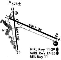
Runways
Runway Summary
| Runways: | 11/29 17/35 |
| Longest Runway: | 11/29 is 8099 ft (2469 m) long |
| Runways with an Instrument Approach: | 29 |
ALN Airport Runway Details
| Runway 11/29 | 8099 ft x 150 ft (2469 m x 46 m) | |
| Runway Length Source: | 3RD PARTY SURVEY as of 10/01/2011 | |
| Surface: | Asphalt - Good condition - Saw-cut or plastic grooved | |
| Runway Pavement Class: | 44 /F/D/X/T | |
| Runway Edge Lights: | High Intensity | |
Runway Weight Bearing Capacity (in thousands of pounds) |
||
| Single Wheel Landing Gear: | 109.0 | |
| Dual Wheel Landing Gear: | 144.0 | |
| Dual Tandem Wheel Landing Gear: | 217.0 | |
Runway 11 |
Runway 29 |
|
Elevation: |
537.8 | 526.4 |
Latitude: |
38-53-42.8608N | 38-53-11.1187N |
Longitude: |
090-03-17.8649W | 090-01-43.8335W |
|
Runway True Alignment: |
113 | 293 |
ILS Type: |
ILS/DME | |
Glide Path Angle: |
3.0 degrees | 0.0 degrees |
Traffic Pattern: |
Left | Left |
Runway Markings Type: |
Precision Instrument | Precision Instrument |
Runway Markings Condition: |
Good | Good |
Object at End: |
TREE | |
Object Height: |
35 | |
Distance from End: |
1275 | |
Object Centerline Offset: |
475 ft. right of centerline | |
Visual Glide Slope Indicators: |
4-Light PAPI On Right Side Of Runway | |
Approach Light System: |
1,400 Foot Medium Intensity Approach Lighting System With Runway Alignment Indicator Lights | |
REIL: |
Yes | No |
Touchdown Lights: |
No | No |
Centerline Lights: |
No | No |
Threshold Crossing Height: |
44 | |
Declared Distances |
||
Take Off Run Avbl. (TORA): |
8099 | 8099 |
Take Off Distance Avbl. (TODA): |
8099 | 8099 |
Actual Stop Dist. Avbl. (ASDA): |
8099 | 8099 |
Landing Dist. Avbl. (LDA): |
8099 | 8099 |
| Runway 17/35 | 6500 ft x 100 ft (1981 m x 30 m) | |
| Runway Length Source: | 3RD PARTY SURVEY as of 10/01/2011 | |
| Surface: | Asphalt - Good condition - No special surface treatment | |
| Runway Pavement Class: | 15 /F/D/X/T | |
| Runway Edge Lights: | Medium Intensity | |
Runway Weight Bearing Capacity (in thousands of pounds) |
||
| Single Wheel Landing Gear: | 57.0 | |
| Dual Wheel Landing Gear: | 73.0 | |
| Dual Tandem Wheel Landing Gear: | 124.0 | |
| Dual Dual Tandem Wheel Landing Gear: | 0.0 | |
Runway 17 |
Runway 35 |
|
Elevation: |
533.4 | 542.3 |
Latitude: |
38-53-51.5045N | 38-52-47.6948N |
Longitude: |
090-03-08.6382W | 090-02-59.1239W |
|
Runway True Alignment: |
173 | 353 |
Glide Path Angle: |
3.0 degrees | 3.0 degrees |
Traffic Pattern: |
Left | Left |
Runway Markings Type: |
Nonprecision Instrument | Nonprecision Instrument |
Runway Markings Condition: |
Fair | Fair |
Object at End: |
TREE | TREES |
Object Height: |
18 | 32 |
Distance from End: |
896 | 1379 |
Object Centerline Offset: |
475 ft. right of centerline | |
Visual Glide Slope Indicators: |
4-Light PAPI On Left Side Of Runway | 4-Light PAPI On Left Side Of Runway |
Touchdown Lights: |
No | No |
Centerline Lights: |
No | No |
Threshold Crossing Height: |
43 | 43 |
Services
Fuel Available: |
100LL, MOGAS |
Landing Fees: |
No |
Maps & Diagrams
ALN Sectional
Flight Planning
at skyvector.com
at skyvector.com