Location
Latitude: |
39-32-52.0320N (39.547787) |
Longitude: |
087-22-38.4690W (-87.377353) |
Elevation: |
496.0 feet MSL (151 m MSL) |
Magnetic Variation: |
4.1 W (as of April 2024 from WMM2020 model) |
Time Zone: |
UTC -5.0 (Standard Time) UTC -4.0 (Daylight Savings Time) |
From City: |
05 N.M. N of Terre Haute, Indiana |
Found On: |
St Louis Chart |
FAA Region: |
AGL |
Contacts
Manager: |
Privately owned: |
| STEVE BROWN 6898 N. CLINTON ST TERRE HAUTE, IN 47805 812-466-2229 |
SKY KING ARPT INC. 6898 N. CLINTON ST TERRE HAUTE, IN 47805 812-466-2229 |
Operations
Airport Status: |
Operational |
Facility Use: |
Public |
Type: |
Airport |
Activation Date: |
04/1962 |
Control tower: |
No |
Attendance (Months/Days/Hours): |
Months/Days/Hours ALL/ALL/0700-DUSK |
Boundary ARTCC: |
ZID (Indianapolis) |
Responsible ARTCC: |
ZID (Indianapolis) |
Lighting Schedule: |
SEE RMK |
Segmented Circle Indicator: |
No |
Traffic Pattern Altitude (MSL): |
1496 feet (456 m) |
NOTAMs Facility: |
HUF |
NOTAM-D Service: |
Yes |
International Airport of Entry: |
No |
Customs Landing Rights: |
No |
Military Landing Rights: |
No |
Civil/Military Joint Use: |
No |
Based Aircraft
| Single Engine: | 29 |
| Multi Engine: | 1 |
Annual Operations (as of 12/31/2019)
| Total Operations: | 18626 | |
| Air Taxi: | 826 | 4.4% |
| GA Local: | 14560 | 78.2% |
| GA Itinerant: | 3240 | 17.4% |
Communications
| CTAF: | 122.800 |
| Unicom: | 122.800 |
| Approach: | HULMAN 125.45 125.45 125.45 |
| Departure: | HULMAN 125.45 125.45 125.45 |
Fixed Based Operators (FBOs) & Fuel
(Click on a business for detail)
Please help us keep this information up to date. This is a FREE SERVICE just like everything else on Airport Guide! If you see that a business needs to be added, modified, or deleted please fill out our Update Form.
To add, modify, or delete a business click here.
Please help us keep this information up to date. This is a FREE SERVICE just like everything else on Airport Guide! If you see that a business needs to be added, modified, or deleted please fill out our Update Form.
Area Code: 812 |
| Business Name | Frequency | Phone | Fuel Grade |
|---|---|---|---|
| Brown Flying School Service, Inc.
Update FBO info |
Unicom 122.8 | 466-2229 | 100LL |
Flight Service Stations
| Primary | Alternate | |
| FSS on Field: | N | |
| FSS Name (ID): | Terre Haute(HUF) | |
| Frequency: | ||
| Toll Free Phone: | 1-800-WX-BRIEF |
Instrument Procedures / Charts
FAA Terminal Procedures valid from 0901Z 03/21/24 to 0901Z 04/18/24.
There are various types of charts available for an airport. They are listed in the Page Type column. Here is a legend for those types:
APD - Airport Diagram
DP - Departure Procedure Charts
HOT - Hot Spots
IAP - Instrument Approach Procedure Charts
MIN - Minimums
STAR - Standard Terminal Arrival Charts
| Page Type | Page Name | Volume | Action Since Last Cycle |
|---|---|---|---|
| IAP | RNAV (GPS)-A | EC-2 | |
| MIN | TAKEOFF MINIMUMS | EC-2 |
Terminal Procedures are only available for airports in several countries with more being added all the time. If you are looking for a specific country's charts, please send an email to support(at)airportguide.com stating the country name. This will be used to prioritize the implementation.
Navigation Aids (Navaids) near 3I3
| Dist (NM) | ID | Morse Code | Name | Type | Freq | True Hdg | Mag Hdg |
|---|---|---|---|---|---|---|---|
| 6.9 | TTH | _ _ . . . . | Terre Haute | VORTAC | 115.30 | 120 | 124 |
| 9.6 | HU | . . . . . . _ | Yinno | NDB | 245 | 185 | 189 |
| 26.2 | SIV | . . . . . . . . _ | Sullivan | NDB | 326 | 187 | 191 |
| 28.2 | TVX | _ . . . _ _ . . _ | Greencastle | NDB | 521 | 69 | 73 |
| 32.4 | CZB | _ . _ . _ _ . . _ . . . | Casey | NDB | 359 | 243 | 247 |
| 33.6 | CFJ | _ . _ . . . _ . . _ _ _ | Crawfordsville | NDB | 388 | 39 | 43 |
| 34.2 | RSV | . _ . . . . . . . _ | Robinson | VOR-DME | 108.40 | 201 | 205 |
| 34.3 | PLX | . _ _ . . _ . . _ . . _ | Palestine | NDB | 391 | 201 | 205 |
| 37.4 | MT | _ _ _ | Zebre | NDB | 347 | 260 | 264 |
| 39.1 | HMJ | . . . . _ _ . _ _ _ | Homer | NDB | 281 | 317 | 321 |
| 42.3 | MTO | _ _ _ _ _ _ | Mattoon | DME | 109.4 | 264 | 268 |
| 43.0 | OOM | _ _ _ _ _ _ _ _ | Hoosier | VORTAC | 110.20 | 124 | 128 |
| 44.8 | CM | _ . _ . _ _ | Veals | NDB | 407 | 304 | 308 |
| 45.1 | DN | _ . . _ . | Julip | NDB | 332 | 351 | 355 |
| 45.5 | DNV | _ . . _ . . . . _ | Danville | VORTAC | 111.00 | 349 | 353 |
| 47.8 | LWV | . _ . . . _ _ . . . _ | Lawrenceville | DME | 108.8 | 192 | 196 |
| 49.3 | VHP | . . . _ . . . . . _ _ . | Brickyard | VORTAC | 116.30 | 70 | 74 |
| 50.6 | IND | . . _ . _ . . | Indianapolis Intl | VOT | 109.60 | 77 | 82 |
| 50.7 | CMI | _ . _ . _ _ . . | Champaign | VORTAC | 110.00 | 305 | 309 |
| 52.1 | OEA | _ _ _ . . _ | Vincennes | NDB | 251 | 189 | 193 |
Nearby Airports with Fuel
Notices to Airmen (NOTAMS)
Remarks
| A110*G | THIS AIRPORT HAS BEEN SURVEYED BY THE NATIONAL GEODETIC SURVEY. |
| A110-2 | FOR CD CTC HULMAN APCH AT 812-877-7581. |
| A30A-09 | 50 FT GND ELEV DROP 60 FT FM RWY THR. |
| A57-18 | APCH SLOPE 20:1 TO DSPLCD THR. |
| A57-27 | APCH SLOPE 15:1 TO DSPLCD THR. |
| A57-36 | APCH SLOPE 17:1 TO DSPLCD THR. |
| A58-27 | 90 FT TREES 195 FT R OF RWY; 20 FT PLINE 40 FT FM RWY END; 50 FT TREES 125 FT FM RWY END. |
| A58-36 | 6 FT FENCE 208 FT R OF RWY & 15 FT FM RWY END; 20 FT TREES 50 FT & 150 FT FM RWY END; 15 FT BRUSH 140 FT L OF RWY END. |
| A81-APT | ACTVT LIRL RWY 09/27 & 18/36 - CTAF. |
| A81-BCN | ACTVT ROTG BCN - CTAF. |
Runways
Runway Summary
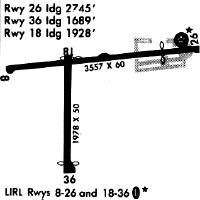
| Runways: | 09/27 18/36 |
| Longest Runway: | 09/27 is 3557 ft (1084 m) long |
| Runways with an Instrument Approach: |
3I3 Airport Runway Details
| Runway 09/27 | 3557 ft x 50 ft (1084 m x 15 m) | |
| Surface: | Asphalt - Fair condition - No special surface treatment | |
| Runway Edge Lights: | Low Intensity | |
Runway 09 |
Runway 27 |
|
Elevation: |
493.0 | 496.0 |
Latitude: |
39-32-53.5820N | 39-32-57.3960N |
Longitude: |
087-22-57.9170W | 087-22-12.7730W |
|
Runway True Alignment: |
084 | 264 |
Glide Path Angle: |
0.0 degrees | 0.0 degrees |
Traffic Pattern: |
Left | Left |
Runway Markings Type: |
Basic | Basic |
Runway Markings Condition: |
Good | Good |
Object at End: |
TREES | TREES |
Object Height: |
60 | 65 |
Distance from End: |
1470 | 201 |
Object Centerline Offset: |
0 ft. left and right of centerline | 0 ft. left and right of centerline |
REIL: |
No | No |
Touchdown Lights: |
No | No |
Centerline Lights: |
No | No |
Threshold Elevation: |
496.0 | |
Displaced Threshold: |
812 | |
Threshold Latitude: |
39-32-56.5258N | |
Threshold Longitude: |
087-22-23.0779W |
| Runway 18/36 | 1978 ft x 50 ft (603 m x 15 m) | |
| Surface: | Asphalt - Fair condition - No special surface treatment | |
| Runway Edge Lights: | Low Intensity | |
Runway 18 |
Runway 36 |
|
Elevation: |
493.0 | 493.0 |
Latitude: |
39-32-55.7220N | 39-32-36.1710N |
Longitude: |
087-22-44.3150W | 087-22-44.0790W |
|
Runway True Alignment: |
179 | 359 |
Glide Path Angle: |
0.0 degrees | 0.0 degrees |
Traffic Pattern: |
Left | Left |
Runway Markings Type: |
Basic | Basic |
Runway Markings Condition: |
Good | Good |
Object at End: |
CROPS | TREE |
Object Height: |
10 | 27 |
Distance from End: |
201 | 201 |
Object Centerline Offset: |
0 ft. left and right of centerline | 0 ft. left and right of centerline |
REIL: |
No | No |
Touchdown Lights: |
No | No |
Centerline Lights: |
No | No |
Threshold Elevation: |
493.0 | 493.0 |
Displaced Threshold: |
50 | 289 |
Threshold Latitude: |
39-32-55.2279N | 39-32-39.0271N |
Threshold Longitude: |
087-22-44.3090W | 087-22-44.1135W |
Services
Airframe Repair: |
Major |
Powerplant Repair: |
Major |
Bottled Oxygen: |
High Pressure |
Bulk Oxygen: |
High Pressure / Low Pressure |
Fuel Available: |
100LL, Jet A, Jet A+ |
Landing Fees: |
No |
Parking: |
Hangars and tiedowns available |
Maps & Diagrams
3I3 Sectional
Flight Planning
at skyvector.com
at skyvector.com