Location
Latitude: |
37-58-10.0000N (37.969444) |
Longitude: |
101-15-20.1000W (-101.255583) |
Elevation: |
3076.4 feet MSL (938 m MSL) |
Magnetic Variation: |
5.5 E (as of April 2024 from WMM2020 model) |
Time Zone: |
UTC -6.0 (Standard Time) UTC -5.0 (Daylight Savings Time) |
From City: |
02 N.M. N of Lakin, Kansas |
Found On: |
Wichita Chart |
FAA Region: |
ACE |
Contacts
Manager: |
Publicly owned: |
| KYMBERLY LOGAN 1662 RD. T LAKIN, KS 67860 620-260-0502 |
KEARNY COUNTY LAKIN, KS 67860 620-355-6422 |
Operations
Airport Status: |
Operational |
Facility Use: |
Public |
Type: |
Airport |
Activation Date: |
06/1955 |
Control tower: |
No |
Attendance (Months/Days/Hours): |
Months/Days/Hours ALL/MON-FRI/0800-1700 |
Boundary ARTCC: |
ZKC (Kansas City) |
Responsible ARTCC: |
ZKC (Kansas City) |
Lighting Schedule: |
SS-SR |
Segmented Circle Indicator: |
No |
Traffic Pattern Altitude (MSL): |
4076 feet (1242 m) |
NOTAMs Facility: |
ICT |
NOTAM-D Service: |
Yes |
Civil/Military Joint Use: |
No |
Based Aircraft
| Single Engine: | 24 |
| Multi Engine: | 1 |
Annual Operations (as of 09/24/2020)
| Total Operations: | 4000 | |
| GA Local: | 3500 | 87.5% |
| GA Itinerant: | 500 | 12.5% |
Communications
| CTAF: | 122.900 |
| AWOS-3PT: | 118.225 (620-355-4004) |
Fixed Based Operators (FBOs) & Fuel
(Click on a business for detail)
Please help us keep this information up to date. This is a FREE SERVICE just like everything else on Airport Guide! If you see that a business needs to be added, modified, or deleted please fill out our Update Form.
To add, modify, or delete a business click here.
Please help us keep this information up to date. This is a FREE SERVICE just like everything else on Airport Guide! If you see that a business needs to be added, modified, or deleted please fill out our Update Form.
Area Code: 620 |
| Business Name | Frequency | Phone | Fuel Grade |
|---|---|---|---|
| Logan Aviation
Website Update FBO info |
620-260-0502 | 100LL | |

|
Unknown |
100LL - 5.08 USD per gallon on 04/16/2024 |
24 Hour Self-Serve Credit Card Pumps Assisted fuel service also available at no extra cost |
Flight Service Stations
| Primary | Alternate | |
| FSS on Field: | N | |
| FSS Name (ID): | Wichita(ICT) | |
| Frequency: | ||
| Toll Free Phone: | 1-800-WX-BRIEF |
Instrument Procedures / Charts
Terminal Procedures are only available for airports in several countries with more being added all the time. If you are looking for a specific country's charts, please send an email to support(at)airportguide.com stating the country name. This will be used to prioritize the implementation.
Navigation Aids (Navaids) near 36K
| Dist (NM) | ID | Morse Code | Name | Type | Freq | True Hdg | Mag Hdg |
|---|---|---|---|---|---|---|---|
| 23.0 | ULS | . . _ . _ . . . . . | Ulysses | NDB | 395 | 193 | 188 |
| 25.3 | GCK | _ _ . _ . _ . _ . _ | Garden City | VORTAC | 113.30 | 96 | 91 |
| 26.5 | GC | _ _ . _ . _ . | Pieve | NDB | 347 | 108 | 103 |
| 30.3 | JHN | . _ _ _ . . . . _ . | Bear Creek | NDB | 341 | 228 | 222 |
| 35.2 | TQK | _ _ _ . _ _ . _ | Scott City | NDB | 256 | 29 | 24 |
| 48.7 | HQG | . . . . _ _ . _ _ _ . | Hugoton | NDB | 365 | 186 | 181 |
| 57.1 | LBL | . _ . . _ . . . . _ . . | Liberal | TACAN | 112.30 | 166 | 161 |
| 59.6 | DDC | _ . . _ . . _ . _ . | Dodge City | VORTAC | 108.20 | 96 | 91 |
| 62.0 | LB | . _ . . _ . . . | Panck | NDB | 383 | 166 | 161 |
| 65.4 | EHA | . . . . . . _ | Elkhart | NDB | 377 | 207 | 201 |
| 69.0 | LAA | . _ . . . _ . _ | Lamar | VOR-DME | 116.90 | 281 | 275 |
| 71.6 | OEL | _ _ _ . . _ . . | Oakley | NDB | 380 | 16 | 11 |
| 76.8 | GUY | _ _ . . . _ _ . _ _ | Guymon | NDB | 275 | 188 | 183 |
| 81.1 | GL | _ _ . . _ . . | Shugr | NDB | 414 | 348 | 342 |
| 87.5 | GLD | _ _ . . _ . . _ . . | Goodland | VORTAC | 115.10 | 346 | 340 |
| 90.5 | ITR | . . _ . _ . | Kit Carson | NDB | 209 | 328 | 322 |
| 91.2 | HLC | . . . . . _ . . _ . _ . | Hill City | VORTAC | 113.70 | 31 | 26 |
| 92.9 | JDM | . _ _ _ _ . . _ _ | Wheatfield | NDB | 408 | 5 | 360 |
| 96.5 | PYX | . _ _ . _ . _ _ _ . . _ | Perryton | NDB | 266 | 165 | 160 |
Nearby Airports with Fuel
Notices to Airmen (NOTAMS)
Remarks
| A110-1 | PUBLIC PHONE AVBL 24 HRS 620-355-6775. |
| A110-2 | FOR CD CTC KANSAS CITY ARTCC AT 913-254-8508. |
| A33-02/20 | ROUGH & UNEVEN. |
| A42-14 | 14/32 NSTD MARKINGS; INCORRECT SPACING, FADED & NARROW WIDTH.. |
| A52-32 | PUBLIC ROAD -5 FT & 250 FT FM THR. |
| A58-14 | 15 FT ROAD 50 FT FROM THLD. |
| A58-32 | PVT ROAD 50 FT FM THR CONTROLLED BY ARPT. |
| E111 | EXISTED PRIOR TO 1959. |
Runways
Runway Summary
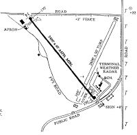
| Runways: | 02/20 14/32 |
| Longest Runway: | 14/32 is 3410 ft (1039 m) long |
| Runways with an Instrument Approach: |
36K Airport Runway Details
| Runway 02/20 | 2579 ft x 90 ft (786 m x 27 m) | |
| Runway Length Source: | 3RD PARTY SURVEY as of 12/09/2009 | |
| Surface: | Turf - Poor condition - No special surface treatment | |
Runway 02 |
Runway 20 |
|
Elevation: |
3060.7 | 3051.3 |
Latitude: |
37-58-01.0595N | 37-58-22.0736N |
Longitude: |
101-15-20.9077W | 101-15-02.6752W |
Glide Path Angle: |
0.0 degrees | 0.0 degrees |
Traffic Pattern: |
Left | Left |
Object at End: |
PLINE | |
Object Height: |
32 | |
Distance from End: |
420 | |
Object Centerline Offset: |
100 ft. left of centerline |
| Runway 14/32 | 3410 ft x 40 ft (1039 m x 12 m) | |
| Runway Length Source: | 3RD PARTY SURVEY as of 12/09/2009 | |
| Surface: | Turf - Poor condition - No special surface treatment | |
| Runway Pavement Class: | 5 /F/C/Y/U | |
| Runway Edge Lights: | Medium Intensity | |
Runway 14 |
Runway 32 |
|
Elevation: |
3076.4 | 3053.9 |
Latitude: |
37-58-23.7918N | 37-57-53.7535N |
Longitude: |
101-15-36.1016W | 101-15-16.7800W |
Glide Path Angle: |
0.0 degrees | 0.0 degrees |
Traffic Pattern: |
Left | Left |
Runway Markings Type: |
Nonstandard (other than numbers only) | Nonstandard (other than numbers only) |
Runway Markings Condition: |
Fair | Fair |
Object at End: |
ROAD | ROAD |
Object Height: |
10 | |
Distance from End: |
250 | |
Object Centerline Offset: |
100 ft. left of centerline |
Services
Airframe Repair: |
Major |
Powerplant Repair: |
Major |
Bottled Oxygen: |
None |
Bulk Oxygen: |
None |
Fuel Available: |
100LL, Jet A-1+ |
Landing Fees: |
No |
Parking: |
Hangars and tiedowns available |
Maps & Diagrams
36K Sectional
Flight Planning
at skyvector.com
at skyvector.com