Location
Latitude: |
42-47-43.3000N (42.795361) |
Longitude: |
070-50-22.0000W (-70.839444) |
Elevation: |
11.0 feet MSL (3 m MSL) |
Magnetic Variation: |
14.3 W (as of April 2024 from WMM2020 model) |
Time Zone: |
UTC -5.0 (Standard Time) UTC -4.0 (Daylight Savings Time) |
From City: |
01 N.M. SE of Newburyport, Massachusetts |
Found On: |
New York Chart |
FAA Region: |
ANE |
Contacts
Manager: |
Privately owned: |
| STEPHEN NOYES/RICHARD COPITHORNE 24 PLUM ISLAND TURNPIKE NEWBURY, MA 01951 978-463-4222 |
SPNEA 141 CAMBRIDGE STREET BOSTON, MA 02114 617-227-3956 |
Operations
Airport Status: |
Operational |
Facility Use: |
Public |
Type: |
Airport |
Activation Date: |
04/1940 |
Control tower: |
No |
Attendance (Months/Days/Hours): |
Months/Days/Hours APR-SEP/ALL/0800-1800 |
Boundary ARTCC: |
ZBW (Boston) |
Responsible ARTCC: |
ZBW (Boston) |
Segmented Circle Indicator: |
No |
Traffic Pattern Altitude (MSL): |
1011 feet (308 m) |
NOTAMs Facility: |
BDR |
NOTAM-D Service: |
Yes |
International Airport of Entry: |
No |
Customs Landing Rights: |
No |
Military Landing Rights: |
No |
Civil/Military Joint Use: |
No |
Based Aircraft
| Single Engine: | 6 |
Annual Operations (as of 07/21/2023)
| Total Operations: | 3075 | |
| GA Local: | 2050 | 66.7% |
| GA Itinerant: | 1000 | 32.5% |
| Military Aircraft: | 25 | 0.8% |
Communications
| CTAF: | 123.000 |
| Unicom: | 123.000 |
| Approach: | BOSTON 124.4 124.4 |
| Departure: | BOSTON 124.4 124.4 |
- CLNC DEL THRU BRIDGEPORT RADIO (BDR) 1-866-293-5149.
Fixed Based Operators (FBOs) & Fuel
(Click on a business for detail)
Please help us keep this information up to date. This is a FREE SERVICE just like everything else on Airport Guide! If you see that a business needs to be added, modified, or deleted please fill out our Update Form.
To add, modify, or delete a business click here.
Please help us keep this information up to date. This is a FREE SERVICE just like everything else on Airport Guide! If you see that a business needs to be added, modified, or deleted please fill out our Update Form.
Area Code: 978 |
| Business Name | Frequency | Phone | Fuel Grade |
|---|
Flight Service Stations
| Primary | Alternate | |
| FSS on Field: | N | |
| FSS Name (ID): | Bridgeport(BDR) | |
| Frequency: | ||
| Toll Free Phone: | 1-800-WX-BRIEF |
Instrument Procedures / Charts
Terminal Procedures are only available for airports in several countries with more being added all the time. If you are looking for a specific country's charts, please send an email to support(at)airportguide.com stating the country name. This will be used to prioritize the implementation.
Navigation Aids (Navaids) near 2B2
| Dist (NM) | ID | Morse Code | Name | Type | Freq | True Hdg | Mag Hdg |
|---|---|---|---|---|---|---|---|
| 11.7 | LWM | . _ . . . _ _ _ _ | Lawrence | DME | 112.5 | 253 | 267 |
| 12.0 | BVY | _ . . . . . . _ _ . _ _ | Beverly | FAN MARKER | 202 | 216 | |
| 17.4 | PSM | . _ _ . . . . _ _ | Pease | DME | 116.5 | 1 | 15 |
| 18.2 | LW | . _ . . . _ _ | Haget | NDB | 402 | 240 | 254 |
| 21.3 | LQ | . _ . . _ _ . _ | Lyndy | NDB | 382 | 194 | 208 |
| 23.7 | MHT | _ _ . . . . _ | Manchester | VOR-DME | 114.40 | 280 | 294 |
| 25.3 | SKR | . . . _ . _ . _ . | Shaker Hill | NDB | 251 | 216 | 230 |
| 25.5 | ESG | . . . . _ _ . | Rollins | NDB | 260 | 1 | 15 |
| 27.1 | BOS | _ . . . _ _ _ . . . | Boston | VOR-DME | 112.70 | 194 | 208 |
| 27.1 | BOS | _ . . . _ _ _ . . . | Boston | VOT | 111.00 | 194 | 208 |
| 28.0 | BED | _ . . . . _ . . | Bedford | VOT | 110.00 | 225 | 239 |
| 30.6 | MJ | _ _ . _ _ _ | Fitzy | NDB | 209 | 277 | 291 |
| 30.8 | BE | _ . . . . | Bedds | NDB | 332 | 232 | 246 |
| 33.2 | CO | _ . _ . _ _ _ | Epsom | NDB | 216 | 305 | 319 |
| 33.6 | AS | . _ . . . | Chern | NDB | 359 | 273 | 287 |
| 39.1 | ENE | . _ . . | Kennebunk | VOR-DME | 117.10 | 14 | 28 |
| 41.1 | CON | _ . _ . _ _ _ _ . | Concord | VOR-DME | 112.90 | 308 | 322 |
| 42.5 | IMR | . . _ _ . _ . | Marshfield | NDB | 368 | 170 | 184 |
| 42.5 | OW | _ _ _ . _ _ | Stoge | NDB | 397 | 197 | 211 |
| 43.1 | FIT | . . _ . . . _ | Fitchburg | NDB | 365 | 250 | 264 |
Nearby Airports with Fuel
Notices to Airmen (NOTAMS)
Remarks
| A10 | HNE, HISTORIC NEW ENGLAND INC. |
| A110-1 | NO TGLS ALLOWED. |
| A110-2 | WILDLIFE INVOF ARPT. |
| A110-3 | FOR CD CTC BOSTON APCH AT 603-594-5552. |
| A110-4 | CTC MGR FOR ALL ARPT USE REQS. OWNER DOES NOT OVERSEE OPS. |
| A58-28 | 4 FT UNLIT FENCE CROSSES RWY. VEHICLE AND EQUIP INVOF RWY. |
| E111 | ESTAB PRIOR 1959 |
Runways
Runway Summary
| Runways: | 10/28 14/32 |
| Longest Runway: | 14/32 is 2300 ft (701 m) long |
| Runways with an Instrument Approach: |
2B2 Airport Runway Details
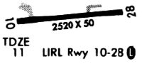
| Runway 10/28 | 2105 ft x 50 ft (642 m x 15 m) | |
| Runway Length Source: | OWNER as of 10/18/2001 | |
| Surface: | Asphalt - Fair condition - No special surface treatment | |
Runway Weight Bearing Capacity (in thousands of pounds) |
||
| Single Wheel Landing Gear: | 8.0 | |
Runway 10 |
Runway 28 |
|
Latitude: |
42-47-42.7100N | 42-47-43.8600N |
Longitude: |
070-50-36.1100W | 070-50-07.9200W |
|
Runway True Alignment: |
087 | 267 |
Glide Path Angle: |
0.0 degrees | 0.0 degrees |
Runway Markings Type: |
Basic | Basic |
Runway Markings Condition: |
Fair | Fair |
Object at End: |
TREES | FENCE |
Object Height: |
100 | 8 |
Distance from End: |
500 | 300 |
Object Centerline Offset: |
100 ft. left and right of centerline | 55 ft. left and right of centerline |
Displaced Threshold: |
300 | |
Threshold Latitude: |
42-47-43.7000N | |
Threshold Longitude: |
070-50-11.9400W |
| Runway 14/32 | 2300 ft x 100 ft (701 m x 30 m) | |
| Runway Length Source: | STATE as of 04/25/2007 | |
| Surface: | Asphalt - Fair condition - No special surface treatment | |
Runway 14 |
Runway 32 |
|
Glide Path Angle: |
0.0 degrees | 0.0 degrees |
Object at End: |
TREES | TREES |
Object Height: |
14 | 66 |
Distance from End: |
200 | 400 |
Object Centerline Offset: |
100 ft. left and right of centerline | 55 ft. left and right of centerline |
Services
Airframe Repair: |
None |
Powerplant Repair: |
None |
Bottled Oxygen: |
None |
Bulk Oxygen: |
None |
Fuel Available: |
100LL |
Landing Fees: |
Yes |
Parking: |
Tiedowns available |
Maps & Diagrams
2B2 Sectional
Flight Planning
at skyvector.com
at skyvector.com