Location
Latitude: |
44-41-18.2000N (44.688389) |
Longitude: |
111-07-03.5000W (-111.117639) |
Elevation: |
6649.0 feet MSL (2027 m MSL) |
Magnetic Variation: |
11.2 E (as of April 2024 from WMM2020 model) |
Time Zone: |
UTC -7.0 (Standard Time) UTC -6.0 (Daylight Savings Time) |
From City: |
01 N.M. N of West Yellowstone, Montana |
Found On: |
Great Falls Chart |
FAA Region: |
ANM |
Contacts
Manager: |
Publicly owned: |
| JEFF KADLEC 721 AIRPORT RD., P.O. BOX 306 WEST YELLOWSTONE, MT 59758-0306 406-646-7631 |
STATE OF MONTANA PO BOX 200507 HELENA, MT 59620 406-444-2506 |
Operations
Airport Status: |
Operational |
Facility Use: |
Public |
Type: |
Airport |
Activation Date: |
11/1979 |
Control tower: |
No |
Attendance (Months/Days/Hours): |
Months/Days/Hours MAY-OCT/ALL/0800-1700 |
Boundary ARTCC: |
ZLC (Salt Lake City) |
Responsible ARTCC: |
ZLC (Salt Lake City) |
Lighting Schedule: |
SEE RMK |
Segmented Circle Indicator: |
Yes |
Traffic Pattern Altitude (MSL): |
7649 feet (2331 m) |
NOTAMs Facility: |
WYS |
NOTAM-D Service: |
Yes |
International Airport of Entry: |
No |
Customs Landing Rights: |
No |
Military Landing Rights: |
Yes |
Civil/Military Joint Use: |
No |
Aircraft Rescue and Firefighting: |
Class I ARFF Index: A Air Carrier Service: Scheduled Certification Date: 05/1973 |
Based Aircraft
| Single Engine: | 2 |
| GA Helicopters: | 2 |
Annual Operations (as of 12/31/2018)
| Total Operations: | 11105 | |
| Air Taxi: | 530 | 4.8% |
| GA Local: | 2500 | 22.5% |
| GA Itinerant: | 8000 | 72.0% |
| Military Aircraft: | 75 | 0.7% |
Communications
| CTAF: | 123.000 |
| Unicom: | 123.000 |
| AWOS-3P: | 118.1 ((406) 646-7727) |
- APCH/DEP CTL SVC PRVDD BY SALT LAKE ARTCC (ZLC) ON FREQS 132.4/338.3 (BOZEMAN RCAG).
Fixed Based Operators (FBOs) & Fuel
(Click on a business for detail)
Please help us keep this information up to date. This is a FREE SERVICE just like everything else on Airport Guide! If you see that a business needs to be added, modified, or deleted please fill out our Update Form.
To add, modify, or delete a business click here.
Please help us keep this information up to date. This is a FREE SERVICE just like everything else on Airport Guide! If you see that a business needs to be added, modified, or deleted please fill out our Update Form.
Area Code: 406 |
| Business Name | Frequency | Phone | Fuel Grade |
|---|---|---|---|
| Yellowstone Aviation
Update FBO info |
Unicom 123.0 | 646-7359, after hours call 646-9327 | 100LL, Jet A |
Flight Service Stations
| Primary | Alternate | |
| FSS on Field: | N | |
| FSS Name (ID): | Great Falls(GTF) | |
| Frequency: | ||
| Toll Free Phone: | 1-800-WX-BRIEF |
Instrument Procedures / Charts
FAA Terminal Procedures valid from 0901Z 03/21/24 to 0901Z 04/18/24.
There are various types of charts available for an airport. They are listed in the Page Type column. Here is a legend for those types:
APD - Airport Diagram
DP - Departure Procedure Charts
HOT - Hot Spots
IAP - Instrument Approach Procedure Charts
MIN - Minimums
STAR - Standard Terminal Arrival Charts
| Page Type | Page Name | Volume | Action Since Last Cycle |
|---|---|---|---|
| IAP | ILS OR LOC RWY 01 | NW-1 | |
| IAP | RNAV (GPS) RWY 01 | NW-1 | |
| IAP | RNAV (GPS) RWY 19 | NW-1 | |
| MIN | TAKEOFF MINIMUMS | NW-1 | |
| ODP | TARGY ONE (OBSTACLE) | NW-1 |
Terminal Procedures are only available for airports in several countries with more being added all the time. If you are looking for a specific country's charts, please send an email to support(at)airportguide.com stating the country name. This will be used to prioritize the implementation.
Navigation Aids (Navaids) near WYS
| Dist (NM) | ID | Morse Code | Name | Type | Freq | True Hdg | Mag Hdg |
|---|---|---|---|---|---|---|---|
| 0.2 | ESY | . . . . _ . _ _ | Yellowstone | NDB | 338 | 296 | 285 |
| 0.9 | WYS | . _ _ _ . _ _ . . . | West Yellowstone | DME | 114.85 | 210 | 199 |
| 7.6 | LO | . _ . . _ _ _ | Targy | NDB | 415 | 206 | 195 |
| 41.5 | EKS | . _ . _ . . . | Ennis | NDB | 286 | 327 | 316 |
| 59.0 | DBS | _ . . _ . . . . . . | Dubois | VORTAC | 116.90 | 232 | 221 |
| 61.6 | DNW | _ . . _ . . _ _ | Dunoir | VOR-DME | 117.20 | 146 | 135 |
| 65.8 | BZN | _ . . . _ _ . . _ . | Bozeman | VOR-DME | 112.40 | 358 | 347 |
| 66.2 | JAC | . _ _ _ . _ _ . _ . | Jackson | VOR-DME | 115.40 | 165 | 154 |
| 67.2 | LVM | . _ . . . . . _ _ _ | Livingston | VOR-DME | 116.10 | 24 | 13 |
| 69.4 | DLN | _ . . . _ . . _ . | Dillon | VOR-DME | 113.00 | 299 | 287 |
| 71.4 | BZ | _ . . . _ _ . . | Manni | NDB | 266 | 354 | 343 |
| 75.2 | ID | . . _ . . | Uconn | NDB | 324 | 209 | 198 |
| 81.1 | IDA | . . _ . . . _ | Idaho Falls | VOR-DME | 113.85 | 210 | 199 |
| 83.2 | HIA | . . . . . . . _ | Whitehall | VOR-DME | 113.70 | 328 | 316 |
| 87.8 | SWU | . . . . _ _ . . _ | Sweden | NDB | 350 | 211 | 200 |
| 92.0 | COD | _ . _ . _ _ _ _ . . | Cody | VOR-DME | 111.80 | 91 | 80 |
| 99.9 | POY | . _ _ . _ _ _ _ . _ _ | Powell | NDB | 344 | 83 | 72 |
Nearby Airports with Fuel
Notices to Airmen (NOTAMS)
Remarks
| A110*G | THIS AIRPORT HAS BEEN SURVEYED BY THE NATIONAL GEODETIC SURVEY. |
| A110-1 | NO SNOW REMOVAL. |
| A110-3 | HEAVY SNOWMOBILE USE ON/ADJACENT RY WINTER MOS. |
| A110-4 | ARPT CLSD OCT 31 THRU MAY1. CHK NOTAMS FOR OPS DATES OR CALL 406-459-9825/406-646-7631. |
| A110-5 | COLD TEMPERATURE AIRPORT. ALTITUDE CORRECTION REQUIRED AT OR BELOW -20C. |
| A110-6 | CONDITIONS UNMONITORED 1700-0800L DAILY. |
| A110-7 | FOR CD CTC SALT LAKE ARTCC AT 801-320-2568 . |
| A16 | IF NO ANSWER CALL 406-459-9825/406-444-2506. |
| A17 | WEATHER DEPENDENT |
| A24 | LDG FEE FOR TURBINE PWRD ACFT. PISTON PWRD EXEMPT. |
| A26 | PPR FOR ACR OPNS WITH MORE THAN 30 PSGR SEATS CALL AMGR 406-646-7631 OR 406-459-9825. |
| A70-FUEL-10 | 0LL FOR FUEL DURG OFF SEASON HRS CALL 406-646-7359. |
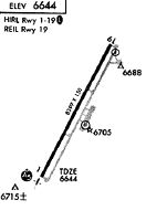
| A81-APT | ACTVT MALSR RWY 01; REIL RWY 19; HIRL RWY 01/19 - CTAF. PAPI RWY 01 & 19 OPR CONSLY. NOT AVBL 31 OCT- 7 MAY . |
Runways
Runway Summary
| Runways: | 01/19 |
| Longest Runway: | 01/19 is 8400 ft (2560 m) long |
| Runways with an Instrument Approach: | 01 |
WYS Airport Runway Details
| Runway 01/19 | 8400 ft x 150 ft (2560 m x 46 m) | |
| Runway Length Source: | NGS as of 10/31/2007 | |
| Surface: | Asphalt - Good condition - Saw-cut or plastic grooved | |
| Runway Pavement Class: | 33 /F/A/X/T | |
| Runway Edge Lights: | High Intensity | |
Runway Weight Bearing Capacity (in thousands of pounds) |
||
| Single Wheel Landing Gear: | 90.0 | |
| Dual Wheel Landing Gear: | 150.0 | |
| Dual Tandem Wheel Landing Gear: | 280.0 | |
Runway 01 |
Runway 19 |
|
Elevation: |
6648.8 | 6634.2 |
Latitude: |
44-40-41.0107N | 44-41-55.3700N |
Longitude: |
111-07-29.2500W | 111-06-37.8286W |
|
Runway True Alignment: |
026 | 206 |
ILS Type: |
ILS | |
Glide Path Angle: |
3.0 degrees | 3.0 degrees |
Traffic Pattern: |
Left | Left |
Runway Markings Type: |
Precision Instrument | Nonprecision Instrument |
Runway Markings Condition: |
Good | Good |
Visual Glide Slope Indicators: |
4-Light PAPI On Left Side Of Runway | 4-Light PAPI On Left Side Of Runway |
Approach Light System: |
1,400 Foot Medium Intensity Approach Lighting System With Runway Alignment Indicator Lights | |
REIL: |
Yes | |
Threshold Crossing Height: |
50 | 53 |
Declared Distances |
||
Take Off Run Avbl. (TORA): |
8400 | 8400 |
Take Off Distance Avbl. (TODA): |
8400 | 8400 |
Actual Stop Dist. Avbl. (ASDA): |
8400 | 8400 |
Landing Dist. Avbl. (LDA): |
8400 | 8400 |
Services
Airframe Repair: |
None |
Powerplant Repair: |
None |
Bottled Oxygen: |
None |
Bulk Oxygen: |
None |
Fuel Available: |
100LL, Jet A |
Landing Fees: |
No |
Parking: |
Hangars and tiedowns available |
Maps & Diagrams
WYS Sectional
Flight Planning
at skyvector.com
at skyvector.com