Location
Latitude: |
42-55-15.9500N (42.921097) |
Longitude: |
112-52-51.2700W (-112.880908) |
Elevation: |
4473.5 feet MSL (1364 m MSL) |
Magnetic Variation: |
11.6 E (as of April 2024 from WMM2020 model) |
Time Zone: |
UTC -7.0 (Standard Time) UTC -6.0 (Daylight Savings Time) |
From City: |
02 N.M. SW of Aberdeen, Idaho |
Found On: |
Salt Lake City Chart |
FAA Region: |
ANM |
Contacts
Manager: |
Publicly owned: |
| ROBERT GOSS P.O. BOX 190 ABERDEEN, ID 83210 208-244-1885 |
CITY OF ABERDEEN P O BOX 190 ABERDEEN, ID 83210 208-397-4161 |
Operations
Airport Status: |
Operational |
Facility Use: |
Public |
Type: |
Airport |
Activation Date: |
04/1940 |
Control tower: |
No |
Attendance (Months/Days/Hours): |
Months/Days/Hours JAN-DEC/MON-SUN/DALGT |
Boundary ARTCC: |
ZLC (Salt Lake City) |
Responsible ARTCC: |
ZLC (Salt Lake City) |
Lighting Schedule: |
SEE RMK |
Segmented Circle Indicator: |
Yes |
Traffic Pattern Altitude (MSL): |
5474 feet (1668 m) |
NOTAMs Facility: |
BOI |
NOTAM-D Service: |
Yes |
International Airport of Entry: |
No |
Customs Landing Rights: |
No |
Military Landing Rights: |
No |
Civil/Military Joint Use: |
No |
Based Aircraft
| Single Engine: | 18 |
| Multi Engine: | 1 |
Annual Operations (as of 06/30/2021)
| Total Operations: | 7500 | |
| GA Local: | 3000 | 40.0% |
| GA Itinerant: | 4500 | 60.0% |
Communications
| CTAF: | 122.900 |
Fixed Based Operators (FBOs) & Fuel
(Click on a business for detail)
Please help us keep this information up to date. This is a FREE SERVICE just like everything else on Airport Guide! If you see that a business needs to be added, modified, or deleted please fill out our Update Form.
To add, modify, or delete a business click here.
Please help us keep this information up to date. This is a FREE SERVICE just like everything else on Airport Guide! If you see that a business needs to be added, modified, or deleted please fill out our Update Form.
Area Code: 208 |
| Business Name | Frequency | Phone | Fuel Grade |
|---|
Flight Service Stations
| Primary | Alternate | |
| FSS on Field: | N | |
| FSS Name (ID): | Boise(BOI) | |
| Frequency: | ||
| Toll Free Phone: | 1-800-WX-BRIEF |
Instrument Procedures / Charts
Terminal Procedures are only available for airports in several countries with more being added all the time. If you are looking for a specific country's charts, please send an email to support(at)airportguide.com stating the country name. This will be used to prioritize the implementation.
Navigation Aids (Navaids) near U36
| Dist (NM) | ID | Morse Code | Name | Type | Freq | True Hdg | Mag Hdg |
|---|---|---|---|---|---|---|---|
| 10.5 | PIH | . _ _ . . . . . . . | Pocatello | VOR-DME | 112.60 | 106 | 94 |
| 16.2 | PI | . _ _ . . . | Tyhee | NDB | 383 | 80 | 68 |
| 43.9 | SWU | . . . . _ _ . . _ | Sweden | NDB | 350 | 45 | 34 |
| 47.3 | MLD | _ _ . _ . . _ . . | Malad City | VOR-DME | 117.40 | 156 | 145 |
| 48.0 | BYI | _ . . . _ . _ _ . . | Burley | VOR-DME | 114.10 | 245 | 233 |
| 50.6 | IDA | . . _ . . . _ | Idaho Falls | VOR-DME | 113.85 | 44 | 33 |
| 56.5 | ID | . . _ . . | Uconn | NDB | 324 | 43 | 32 |
| 64.5 | HLE | . . . . . _ . . . | Hailey | NDB-DME | 220 | 292 | 280 |
| 70.2 | TW | _ . _ _ | Strik | NDB | 389 | 248 | 236 |
| 75.7 | TWF | _ . _ _ . . _ . | Twin Falls | VORTAC | 113.10 | 250 | 238 |
| 75.9 | DBS | _ . . _ . . . . . . | Dubois | VORTAC | 116.90 | 22 | 10 |
| 77.9 | LHO | . _ . . . . . . _ _ _ | Brigham City | VOR-DME | 112.90 | 149 | 138 |
| 78.8 | HDG | . . . . _ . . _ _ . | Steelhead | NDB | 211 | 270 | 258 |
| 91.6 | BMC | _ . . . _ _ _ . _ . | Brigham City | NDB | 294 | 156 | 145 |
Nearby Airports with Fuel
Notices to Airmen (NOTAMS)
Remarks
| A110-1 | IREG WINTER MAINTENANCE. |
| A110-2 | CONSIDERABLE AGRICULTURE OPS DURING GROWING SEASON. |
| A110-3 | +30 FT SPRINKLER AND TERRAIN AT 230 FT FM SW END OF RY MAY BE IN POSITION. |
| A110-4 | FOR CD CTC SALT LAKE ARTCC AT 801-320-2568. |
| A52-07 | +70 FT PLINE & TERRAIN AT 3000 FT ON CNTRLN. |
| A52-25 | +50 FT TREE AT 400 FT; 125 FT LEFT. |
| A58-07 | +4' FENCE AT 0', 100' RIGHT. |
| A58-25 | +3 FT FENCE AT 0 FT, 90 FT R. +18 FT ROAD AT 0 FT 100 FT R. |
| A81-APT | ACTVT MIRL RY 07/25 - CTAF. |
| E111 | ESTABD PRIOR TO 15 MAY 1959. |
Runways
Runway Summary
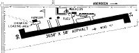
| Runways: | 07/25 |
| Longest Runway: | 07/25 is 3690 ft (1125 m) long |
| Runways with an Instrument Approach: |
U36 Airport Runway Details
| Runway 07/25 | 3690 ft x 50 ft (1125 m x 15 m) | |
| Runway Length Source: | FAA as of 12/05/2012 | |
| Surface: | Asphalt - Fair condition - No special surface treatment | |
| Runway Edge Lights: | Medium Intensity | |
Runway 07 |
Runway 25 |
|
Elevation: |
4473.5 | 4443.4 |
Latitude: |
42-55-13.1100N | 42-55-18.7900N |
Longitude: |
112-53-15.7600W | 112-52-26.7800W |
Glide Path Angle: |
0.0 degrees | 0.0 degrees |
Traffic Pattern: |
Left | Left |
Runway Markings Type: |
Basic | Basic |
Runway Markings Condition: |
Fair | Fair |
Object at End: |
ROAD | FENCE |
Object Height: |
15 | 2 |
Distance from End: |
210 | 200 |
Object Centerline Offset: |
0 ft. left and right of centerline | 0 ft. left and right of centerline |
Threshold Elevation: |
4473.1 | 4444.6 |
Displaced Threshold: |
142 | 512 |
Threshold Latitude: |
42-55-13.3300N | 42-55-18.0000N |
Threshold Longitude: |
112-53-13.8800W | 112-52-33.5800W |
Declared Distances |
||
Take Off Run Avbl. (TORA): |
3690 | 3458 |
Take Off Distance Avbl. (TODA): |
3690 | 3458 |
Actual Stop Dist. Avbl. (ASDA): |
3466 | 3624 |
Landing Dist. Avbl. (LDA): |
3324 | 3112 |
Services
Airframe Repair: |
Major |
Powerplant Repair: |
Major |
Bottled Oxygen: |
None |
Bulk Oxygen: |
None |
Fuel Available: |
100LL, MOGAS |
Landing Fees: |
No |
Parking: |
Tiedowns available |
Maps & Diagrams
U36 Sectional
Flight Planning
at skyvector.com
at skyvector.com