Location
Latitude: |
47-16-04.6000N (47.267944) |
Longitude: |
122-34-41.2000W (-122.578111) |
Elevation: |
294.8 feet MSL (90 m MSL) |
Magnetic Variation: |
15.2 E (as of April 2024 from WMM2020 model) |
Time Zone: |
UTC -8.0 (Standard Time) UTC -7.0 (Daylight Savings Time) |
From City: |
04 N.M. W of Tacoma, Washington |
Found On: |
Seattle Chart |
FAA Region: |
ANM |
Contacts
Manager: |
Publicly owned: |
| ROD PROPST 1202 - 26TH AVE. N.W. GIG HARBOR, WA 98335-7322 253-798-8550 |
PIERCE COUNTY PUB WORKS & UTILITIES 9850 - 64TH ST. W. UNIVERSITY PLACE, WA 98467-7322 253-798-2421 |
Operations
Airport Status: |
Operational |
Facility Use: |
Public |
Type: |
Airport |
Control tower: |
Yes |
Attendance (Months/Days/Hours): |
Months/Days/Hours ALL/ALL/0700-1600 |
Boundary ARTCC: |
ZSE (Seattle) |
Responsible ARTCC: |
ZSE (Seattle) |
Lighting Schedule: |
SEE RMK |
Segmented Circle Indicator: |
Yes |
Traffic Pattern Altitude (MSL): |
1295 feet (395 m) |
NOTAMs Facility: |
TIW |
NOTAM-D Service: |
Yes |
International Airport of Entry: |
No |
Customs Landing Rights: |
Yes |
Military Landing Rights: |
Yes |
Civil/Military Joint Use: |
No |
Based Aircraft
| Single Engine: | 86 |
| Multi Engine: | 9 |
| Jet Engine: | 5 |
| GA Helicopters: | 3 |
Annual Operations (as of 12/31/2022)
| Total Operations: | 53276 | |
| Air Taxi: | 805 | 1.5% |
| GA Local: | 21531 | 40.4% |
| GA Itinerant: | 30274 | 56.8% |
| Military Aircraft: | 666 | 1.3% |
Communications
| CTAF: | 118.500 |
| Unicom: | 122.950 |
| Tower: | TACOMA 118.5 253.5 Hrs: 0800-2000 |
| Ground: | 121.8 |
| Approach: | SEATTLE 120.1 120.1 |
| Departure: | SEATTLE 120.1 120.1 |
| ATIS: | 124.05 Hrs: 24 |
| ASOS: | (253-858-6507) |
- FREQ 121.5 NOT AVBL.
Fixed Based Operators (FBOs) & Fuel
(Click on a business for detail)
Please help us keep this information up to date. This is a FREE SERVICE just like everything else on Airport Guide! If you see that a business needs to be added, modified, or deleted please fill out our Update Form.
To add, modify, or delete a business click here.
Please help us keep this information up to date. This is a FREE SERVICE just like everything else on Airport Guide! If you see that a business needs to be added, modified, or deleted please fill out our Update Form.
Area Code: 253 |
| Business Name | Frequency | Phone | Fuel Grade |
|---|---|---|---|
| Associated Aircraft
Update FBO info |
Unicom 122.95 | 800-925-1490, 851-2381 | |
| Avionics Shop, Inc.
Update FBO info |
851-3009 | ||
| Crossings Aviation
Update FBO info |
Unicom 122.95 | 800-925-1490, 851-2381 | 100LL, Jet A |
| Pavco Flight Center
Update FBO info |
Unicom 122.95 | 800-645-3563, 851-5577 | 100LL, Jet A |
| Tosch Aircraft Industries
Update FBO info |
851-6977 | ||
| Zephyr Aviation
Update FBO info |
Unicom 122.875 | 800-359-2210, 851-8083 | 100LL, Jet A |
Flight Service Stations
| Primary | Alternate | |
| FSS on Field: | N | |
| FSS Name (ID): | Seattle(SEA) | |
| Frequency: | ||
| Toll Free Phone: | 1-800-WX-BRIEF |
Instrument Procedures / Charts
FAA Terminal Procedures valid from 0901Z 03/21/24 to 0901Z 04/18/24.
There are various types of charts available for an airport. They are listed in the Page Type column. Here is a legend for those types:
APD - Airport Diagram
DP - Departure Procedure Charts
HOT - Hot Spots
IAP - Instrument Approach Procedure Charts
MIN - Minimums
STAR - Standard Terminal Arrival Charts
| Page Type | Page Name | Volume | Action Since Last Cycle |
|---|---|---|---|
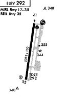
| APD | AIRPORT DIAGRAM | NW-1 | |
| DP | NARROWS ONE | NW-1 | |
| IAP | ILS OR LOC RWY 17 | NW-1 | |
| IAP | RNAV (GPS) RWY 17 | NW-1 | |
| IAP | RNAV (GPS) RWY 35 | NW-1 | |
| MIN | ALTERNATE MINIMUMS | NW-1 | |
| MIN | TAKEOFF MINIMUMS | NW-1 |
Terminal Procedures are only available for airports in several countries with more being added all the time. If you are looking for a specific country's charts, please send an email to support(at)airportguide.com stating the country name. This will be used to prioritize the implementation.
Navigation Aids (Navaids) near TIW
| Dist (NM) | ID | Morse Code | Name | Type | Freq | True Hdg | Mag Hdg |
|---|---|---|---|---|---|---|---|
| 7.1 | GRF | _ _ . . _ . . . _ . | Graye | NDB | 216 | 188 | 173 |
| 8.3 | TCM | _ _ . _ . _ _ | Mcchord | TACAN | 109.60 | 149 | 134 |
| 13.6 | CAN | _ . _ . . _ _ . | Carney | NDB | 274 | 309 | 294 |
| 14.8 | SEA | . . . . . _ | Seattle | VORTAC | 116.80 | 47 | 32 |
| 15.3 | PWT | . _ _ . . _ _ _ | Kitsap | NDB | 206 | 331 | 316 |
| 15.6 | LAC | . _ . . . _ _ . _ . | Lacomas | NDB | 328 | 176 | 161 |
| 15.9 | SEA | . . . . . _ | Seattle-Tacoma | VOT | 117.50 | 44 | 29 |
| 19.2 | BFI | _ . . . . . _ . . . | Seattle | VOT | 108.60 | 35 | 20 |
| 19.3 | HPK | . . . . . _ _ . _ . _ | Parkk | NDB | 281 | 34 | 19 |
| 20.1 | RNT | . _ . _ . _ | Renton | NDB | 353 | 47 | 32 |
| 20.7 | MNC | _ _ _ . _ . _ . | Mason County | NDB | 348 | 266 | 251 |
| 22.2 | OLM | _ _ _ . _ . . _ _ | Olympia | VORTAC | 113.40 | 216 | 201 |
| 23.2 | BF | _ . . . . . _ . | Nolla | NDB | 362 | 19 | 4 |
| 41.0 | PAE | . _ _ . . _ . | Paine | VOR-DME | 110.60 | 17 | 2 |
| 51.4 | AW | . _ . _ _ | Waton | NDB | 382 | 19 | 4 |
| 58.9 | CVV | _ . _ . . . . _ . . . _ | Penn Cove | VOR-DME | 117.20 | 354 | 339 |
| 62.0 | NOW | _ . _ _ _ . _ _ | Ediz Hook | NDB | 338 | 327 | 312 |
| 65.3 | NUW | _ . . . _ . _ _ | Whidbey Island | TACAN | 113.80 | 357 | 342 |
| 67.0 | HQM | . . . . _ _ . _ _ _ | Hoquiam | VORTAC | 117.70 | 253 | 238 |
| 68.2 | LSO | . _ . . . . . _ _ _ | Kelso | NDB | 256 | 191 | 176 |
Nearby Airports with Fuel
Notices to Airmen (NOTAMS)
Remarks
| A110-1 | NOISE SENSITIVE ARPT; FOR NOISE ABATEMENT & TFC PROCEDURES CALL AIRPORT OFFICE 253-798-8550. |
| A110-2 | DEER ON & INVOF ARPT. |
| A110-3 | (E94) LAWRS OPERS DURING TWR OPNS ONLY. |
| A110-4 | EMERG FREQ 121.5 NOT MNT AT TWR. |
| A110-5 | FOR CD WHEN ATCT IS CLSD CTC SEATTLE APCH AT 206-214-4723. |
| A43-35 | PAPI UNUSBL BYD 5.0 DEGREES LEFT OF CNTRLN. |
| A75 | PILOTS BRING OWN TIEDOWNS. |
| A81-APT | WHEN ATCT CLSD, ACTVT MALSR RWY 17; REIL RWY 35; PAPI RWY 17 & 35; MIRL 17/35 - CTAF. |
| E80 | FOR CUSTOMS CALL 253-593-6338 EXT #2. |
Runways
Runway Summary
| Runways: | 17/35 |
| Longest Runway: | 17/35 is 5002 ft (1525 m) long |
| Runways with an Instrument Approach: | 17 |
TIW Airport Runway Details
| Runway 17/35 | 5002 ft x 100 ft (1525 m x 30 m) | |
| Runway Length Source: | 3RD PARTY SURVEY as of 03/15/2017 | |
| Surface: | Asphalt - Good condition - Saw-cut or plastic grooved | |
| Runway Edge Lights: | Medium Intensity | |
Runway Weight Bearing Capacity (in thousands of pounds) |
||
| Single Wheel Landing Gear: | 50.0 | |
| Dual Wheel Landing Gear: | 80.0 | |
| Dual Tandem Wheel Landing Gear: | 80.0 | |
| Dual Dual Tandem Wheel Landing Gear: | 150.0 | |
Runway 17 |
Runway 35 |
|
Elevation: |
291.8 | 294.7 |
Latitude: |
47-16-29.0814N | 47-15-40.0870N |
Longitude: |
122-34-36.7617W | 122-34-45.6077W |
|
Runway True Alignment: |
187 | 007 |
ILS Type: |
ILS | |
Glide Path Angle: |
3.0 degrees | 3.0 degrees |
Traffic Pattern: |
Left | Right |
Runway Markings Type: |
Precision Instrument | Nonprecision Instrument |
Runway Markings Condition: |
Good | Good |
Visual Glide Slope Indicators: |
4-Light PAPI On Right Side Of Runway | 4-Light PAPI On Left Side Of Runway |
Approach Light System: |
1,400 Foot Medium Intensity Approach Lighting System With Runway Alignment Indicator Lights | |
REIL: |
No | Yes |
Threshold Crossing Height: |
52 | 45 |
Services
Airframe Repair: |
None |
Powerplant Repair: |
None |
Bottled Oxygen: |
None |
Bulk Oxygen: |
None |
Fuel Available: |
100LL |
Landing Fees: |
Yes |
Parking: |
Tiedowns available |
Maps & Diagrams
TIW Sectional
Flight Planning
at skyvector.com
at skyvector.com