Location
Latitude: |
34-31-06.8000N (34.518556) |
Longitude: |
109-22-43.5000W (-109.37875) |
Elevation: |
5736.5 feet MSL (1748 m MSL) |
Magnetic Variation: |
9 E (as of April 2024 from WMM2020 model) |
Time Zone: |
UTC -7.0 (Standard Time) UTC -7.0 (Daylight Savings Time) |
From City: |
01 N.M. N of St. Johns, Arizona |
Found On: |
Phoenix Chart |
FAA Region: |
AWP |
Contacts
Manager: |
Publicly owned: |
| GARY LISTON P.O. BOX 455 ST. JOHNS, AZ 85936 928-337-4254 |
CITY OF ST. JOHNS P.O. BOX 455 ST. JOHNS, AZ 85936 928-337-4517 |
Operations
Airport Status: |
Operational |
Facility Use: |
Public |
Type: |
Airport |
Activation Date: |
04/1940 |
Control tower: |
No |
Attendance (Months/Days/Hours): |
Months/Days/Hours ALL/ALL/0700-1700 |
Boundary ARTCC: |
ZAB (Albuquerque) |
Responsible ARTCC: |
ZAB (Albuquerque) |
Lighting Schedule: |
SEE RMK |
Segmented Circle Indicator: |
Yes |
Traffic Pattern Altitude (MSL): |
6736 feet (2053 m) |
NOTAMs Facility: |
SJN |
NOTAM-D Service: |
Yes |
International Airport of Entry: |
No |
Customs Landing Rights: |
No |
Military Landing Rights: |
Yes |
Civil/Military Joint Use: |
No |
Based Aircraft
| Single Engine: | 4 |
| Ultralights: | 1 |
Annual Operations (as of 04/07/2021)
| Total Operations: | 16800 | |
| GA Local: | 3500 | 20.8% |
| GA Itinerant: | 13000 | 77.4% |
| Military Aircraft: | 300 | 1.8% |
Communications
| CTAF: | 122.800 |
| Unicom: | 122.800 |
| ASOS: | 134.225 (928-337-3061) |
- APCH/DEP SVC PRVDD BY ALBUQUERQUE ARTCC (ZAB) ON FREQS 124.325/288.25 (ZUNI RCAG).
Fixed Based Operators (FBOs) & Fuel
(Click on a business for detail)
Please help us keep this information up to date. This is a FREE SERVICE just like everything else on Airport Guide! If you see that a business needs to be added, modified, or deleted please fill out our Update Form.
To add, modify, or delete a business click here.
Please help us keep this information up to date. This is a FREE SERVICE just like everything else on Airport Guide! If you see that a business needs to be added, modified, or deleted please fill out our Update Form.
Area Code: 520 |
| Business Name | Frequency | Phone | Fuel Grade |
|---|---|---|---|
| Airport Management
Update FBO info |
Unicom 122.8 | 337-4254 | 100LL, Jet A, Mogas |
Flight Service Stations
| Primary | Alternate | |
| FSS on Field: | N | |
| FSS Name (ID): | Prescott(PRC) | |
| Frequency: | ||
| Toll Free Phone: | 1-800-WX-BRIEF |
Instrument Procedures / Charts
FAA Terminal Procedures valid from 0901Z 03/21/24 to 0901Z 04/18/24.
There are various types of charts available for an airport. They are listed in the Page Type column. Here is a legend for those types:
APD - Airport Diagram
DP - Departure Procedure Charts
HOT - Hot Spots
IAP - Instrument Approach Procedure Charts
MIN - Minimums
STAR - Standard Terminal Arrival Charts
| Page Type | Page Name | Volume | Action Since Last Cycle |
|---|---|---|---|
| IAP | RNAV (GPS) RWY 14 | SW-4 | |
| IAP | RNAV (GPS) RWY 32 | SW-4 | |
| IAP | VOR-A | SW-4 | |
| MIN | ALTERNATE MINIMUMS | SW-4 | |
| MIN | TAKEOFF MINIMUMS | SW-4 |
Terminal Procedures are only available for airports in several countries with more being added all the time. If you are looking for a specific country's charts, please send an email to support(at)airportguide.com stating the country name. This will be used to prioritize the implementation.
Navigation Aids (Navaids) near SJN
| Dist (NM) | ID | Morse Code | Name | Type | Freq | True Hdg | Mag Hdg |
|---|---|---|---|---|---|---|---|
| 12.9 | SJN | . . . . _ _ _ _ . | St Johns | VORTAC | 112.30 | 115 | 106 |
| 29.0 | ZUN | _ _ . . . . _ _ . | Zuni | VORTAC | 113.40 | 22 | 13 |
| 34.6 | SOW | . . . _ _ _ . _ _ | Show Low | NDB | 206 | 244 | 235 |
| 62.6 | GUP | _ _ . . . _ . _ _ . | Gallup | VORTAC | 115.10 | 23 | 14 |
| 70.4 | AWR | . _ . _ _ . _ . | Window Rock | NDB | 254 | 12 | 3 |
| 77.0 | INW | . . _ . . _ _ | Winslow | VORTAC | 112.60 | 295 | 286 |
| 98.2 | PAN | . _ _ . . _ _ . | Payson | DME | 116.35 | 261 | 252 |
Nearby Airports with Fuel
| Dist (NM) | Name (Airport IDs) | True Hdg | Mag Hdg | Fuel Grade |
|---|---|---|---|---|
| 34.6 | Show Low Regional Airport (SOW KSOW SOW) |
244 | 235 | 100LL, Jet A |
| 36.6 | Taylor Airport (TYZ KTYL TYL) |
264 | 255 | 100LL |
| 45.2 | Holbrook Municipal Airport (P14) |
304 | 295 | 100LL |
| 66.2 | Gallup Municipal Airport (GUP KGUP GUP) |
25 | 16 | 100LL, Jet A-1+ |
| 69.7 | Window Rock Airport (KRQE RQE) |
12 | 3 | 100LL |
| 72.8 | Winslow-Lindbergh Regional Airport (INW KINW INW) |
294 | 284 | 100LL, Jet A |
| 82.5 | Grants-Milan Municipal Airport (GNT KGNT GNT) |
61 | 53 | 100LL, Jet A-1+ |
| 94.9 | San Carlos Apache Airport (P13) |
222 | 213 | 100LL, Jet A |
| 98.3 | Payson Airport (PJB KPAN PAN) |
261 | 251 | 100LL, Jet A+ |
Notices to Airmen (NOTAMS)
Remarks
| A110-1 | MILITARY TFC NEAR AIRPORT. |
| A110-4 | TWY PARALLEL TO RY 14/32 HAS REFLECTORS ENTIRE LENGTH OF TWY ON BOTH SIDES. |
| A110-5 | RY 32 CALM WIND RY. |
| A110-6 | FOR CD IF UNA TO CTC ON FSS FREQ, CTC ALBUQUERQUE ARTCC AT 505-856-4561. |
| A16 | EMERGENCY PHONE: 928-245-0391 |
| A31-03/21 | RY 03 200 FT GRAVEL CLEAR AREA ON S END OF RY. |
| A43-14 | PAPI OTS INDEFLY. |
| A43-32 | PAPI OTS INDEFLY. |
| A52-14 | CONTROLLING OBJECT IS OBSTRUCTION LIGHTS ON POLE. |
| A57-03 | APCH RATIO 16:1 TO DSPLCD THLD BASED ON 60' TREE 1018 FT. FROM DISPLACED THRESHOLD, ON CENTERLINE. |
| A57-32 | APCH RATIO 27:1 AT DSPLCD THLD. |
| A58-32 | RY 32 0 FT-12 FT FENCE 0 FT-200 FT FM THRLD 135 FT 150 FT R OF CNTRLN. +10' ROAD 0'-150' ACROSS APPROACH AREA. |
| A75 | CALL AHEAD FOR AVAILABILITY. |
| A81-APT | ACTVT REIL RWY 14 & 32; PAPI RWY 14 & 32; MIRL RWY 03/21 & 14/32 - CTAF. |
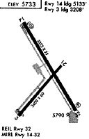
Runways
Runway Summary
| Runways: | 03/21 14/32 |
| Longest Runway: | 14/32 is 5322 ft (1622 m) long |
| Runways with an Instrument Approach: |
SJN Airport Runway Details
| Runway 03/21 | 3400 ft x 60 ft (1036 m x 18 m) | |
| Runway Length Source: | 3RD PARTY SURVEY as of 02/28/2011 | |
| Surface: | Asphalt - Good condition - No special surface treatment | |
| Runway Edge Lights: | Medium Intensity | |
Runway Weight Bearing Capacity (in thousands of pounds) |
||
| Single Wheel Landing Gear: | 55.0 | |
Runway 03 |
Runway 21 |
|
Elevation: |
5727.0 | 5734.7 |
Latitude: |
34-30-45.5915N | 34-31-12.4540N |
Longitude: |
109-22-59.4925W | 109-22-35.0656W |
|
Runway True Alignment: |
037 | 217 |
Glide Path Angle: |
0.0 degrees | 0.0 degrees |
Traffic Pattern: |
Left | Left |
Runway Markings Type: |
Basic | Basic |
Runway Markings Condition: |
Poor | Poor |
Object at End: |
TREE | |
Object Height: |
39 | |
Distance from End: |
440 | |
Object Centerline Offset: |
75 ft. left of centerline | |
REIL: |
No | No |
Touchdown Lights: |
No | No |
Centerline Lights: |
No | No |
Threshold Elevation: |
5727.0 | |
Displaced Threshold: |
190 | |
Threshold Latitude: |
34-30-47.0900N | |
Threshold Longitude: |
109-22-58.1305W |
| Runway 14/32 | 5322 ft x 75 ft (1622 m x 23 m) | |
| Runway Length Source: | 3RD PARTY SURVEY as of 02/28/2011 | |
| Surface: | Asphalt - Good condition - No special surface treatment | |
| Runway Edge Lights: | Medium Intensity | |
Runway Weight Bearing Capacity (in thousands of pounds) |
||
| Single Wheel Landing Gear: | 90.0 | |
Runway 14 |
Runway 32 |
|
Elevation: |
5734.1 | 5736.5 |
Latitude: |
34-31-34.2279N | 34-30-49.4391N |
Longitude: |
109-22-57.7965W | 109-22-24.4261W |
|
Runway True Alignment: |
148 | 328 |
Glide Path Angle: |
3.0 degrees | 3.0 degrees |
Traffic Pattern: |
Left | Left |
Runway Markings Type: |
Nonprecision Instrument | Nonprecision Instrument |
Runway Markings Condition: |
Poor | Poor |
Object at End: |
POLE | |
Object Height: |
17 | |
Object Marked/Lighted?: |
Lighted | |
Distance from End: |
375 | |
Object Centerline Offset: |
75 ft. left of centerline | |
Visual Glide Slope Indicators: |
2-Light PAPI On Left Side Of Runway | 2-Light PAPI On Right Side Of Runway |
REIL: |
Yes | Yes |
Touchdown Lights: |
No | No |
Centerline Lights: |
No | No |
Threshold Crossing Height: |
40 | 40 |
Threshold Elevation: |
5736.5 | |
Displaced Threshold: |
92 | |
Threshold Latitude: |
34-30-50.2123N | |
Threshold Longitude: |
109-22-25.0013W |
Services
Airframe Repair: |
Major |
Powerplant Repair: |
Major |
Fuel Available: |
100LL, Jet A+ |
Landing Fees: |
No |
Parking: |
Tiedowns available |
Maps & Diagrams
SJN Sectional
Flight Planning
at skyvector.com
at skyvector.com