Location
Latitude: |
61-50-40.3500N (61.844542) |
Longitude: |
165-34-25.5000W (-165.57375) |
Elevation: |
22.0 feet MSL (7 m MSL) |
Magnetic Variation: |
8 E (as of April 2024 from WMM2020 model) |
Time Zone: |
UTC -9.0 (Standard Time) UTC -8.0 (Daylight Savings Time) |
From City: |
00 N.M. N of Scammon Bay, Alaska |
Found On: |
Bethel Chart |
FAA Region: |
AAL |
Contacts
Manager: |
Publicly owned: |
| JOSEPH LARAUX PO BOX 505 BETHEL, AK 99559 (907) 543-2498 |
ALASKA DOT&PF CENTRAL REGION PO BOX 196900 ANCHORAGE, AK 99519-6900 (907) 269-0749 |
Operations
Airport Status: |
Operational |
Facility Use: |
Public |
Type: |
Airport |
Activation Date: |
06/1973 |
Control tower: |
No |
Attendance (Months/Days/Hours): |
Months/Days/Hours Unattended |
Boundary ARTCC: |
ZAN (Anchorage) |
Responsible ARTCC: |
ZAN (Anchorage) |
Lighting Schedule: |
SEE RMK |
Segmented Circle Indicator: |
Yes |
Traffic Pattern Altitude (MSL): |
1022 feet (312 m) |
NOTAMs Facility: |
SCM |
NOTAM-D Service: |
Yes |
International Airport of Entry: |
No |
Customs Landing Rights: |
No |
Military Landing Rights: |
Yes |
Civil/Military Joint Use: |
No |
Based Aircraft
Annual Operations (as of 12/31/2022)
| Total Operations: | 500 | |
| Air Taxi: | 500 | 100.0% |
Communications
| CTAF: | 123.000 |
| Unicom: | 123.000 |
| AWOS-3P: | 118.425 (907-558-5501) |
- APCH/DEP SVC PRVDD BY ANCHORAGE ARTCC ON FREQ 124.5 (CAPE ROMANZOF RCAG).
Fixed Based Operators (FBOs) & Fuel
(Click on a business for detail)
Please help us keep this information up to date. This is a FREE SERVICE just like everything else on Airport Guide! If you see that a business needs to be added, modified, or deleted please fill out our Update Form.
To add, modify, or delete a business click here.
Please help us keep this information up to date. This is a FREE SERVICE just like everything else on Airport Guide! If you see that a business needs to be added, modified, or deleted please fill out our Update Form.
Area Code: 907 |
| Business Name | Frequency | Phone | Fuel Grade |
|---|
Flight Service Stations
| Primary | Alternate | |
| FSS on Field: | N | |
| FSS Name (ID): | Kenai(ENA) | |
| Frequency: | ||
| Toll Free Phone: | 1-866-864-1737 |
Instrument Procedures / Charts
FAA Terminal Procedures valid from 0901Z 03/21/24 to 0901Z 04/18/24.
There are various types of charts available for an airport. They are listed in the Page Type column. Here is a legend for those types:
APD - Airport Diagram
DP - Departure Procedure Charts
HOT - Hot Spots
IAP - Instrument Approach Procedure Charts
MIN - Minimums
STAR - Standard Terminal Arrival Charts
| Page Type | Page Name | Volume | Action Since Last Cycle |
|---|---|---|---|
| IAP | RNAV (GPS) RWY 10 | AK-1 | |
| IAP | RNAV (GPS) RWY 28 | AK-1 | |
| IAP | RNAV (GPS)-B | AK-1 | |
| MIN | ALTERNATE MINIMUMS | AK-1 | |
| MIN | TAKEOFF MINIMUMS | AK-1 |
Terminal Procedures are only available for airports in several countries with more being added all the time. If you are looking for a specific country's charts, please send an email to support(at)airportguide.com stating the country name. This will be used to prioritize the implementation.
Navigation Aids (Navaids) near SCM
| Dist (NM) | ID | Morse Code | Name | Type | Freq | True Hdg | Mag Hdg |
|---|---|---|---|---|---|---|---|
| 11.7 | CZF | _ . _ . _ _ . . . . _ . | Cape Romanzof | NDB | 275 | 254 | 246 |
| 13.9 | CZF | _ . _ . _ _ . . . . _ . | Cape Romanzof | DME | 116.75 | 253 | 245 |
| 25.4 | HPB | . . . . . _ _ . _ . . . | Hooper Bay | VOR-DME | 115.20 | 219 | 211 |
| 64.0 | ENM | . _ . _ _ | Emmonak | VOR-DME | 117.80 | 27 | 19 |
| 65.9 | SMA | . . . _ _ . _ | St Marys | NDB | 230 | 77 | 68 |
| 89.5 | AIX | . _ . . _ . . _ | Nanwak | NDB-DME | 323 | 192 | 184 |
Nearby Airports with Fuel
| Dist (NM) | Name (Airport IDs) | True Hdg | Mag Hdg | Fuel Grade |
|---|
Notices to Airmen (NOTAMS)
Remarks
| A110-1 | RWY CONDITION NOT MONITORED; RECOMMEND VISUAL INSPECTION PRIOR TO USING. |
| A110-2 | BIRDS ON RWY. |
| A110-4 | WX CAMERA AVBL ON INTERNET AT HTTPS://WEATHERCAMS.FAA.GOV/. |
| A110-7 | BE ALERT: GUSTY CROSSWINDS COMMON. |
| A110-8 | RWY EDGES SOFT AND SLOUGHING TOWARDS TUNDRA. |
| A110-9 | COLD TEMPERATURE AIRPORT. ALTITUDE CORRECTION REQUIRED AT OR BELOW -21C. |
| A30-10/28 | ROAD USED TO CROSS RWY TO RIVER. |
| A33-10/28 | RWY 28 SAFETY AREA SOFT AND CONTAINS LARGE ROCKS; ONLY 75 FT USABLE. |
| A33-10/28 1 | RWY 10/28 SOFT DURG SPRING BREAKUP, AFTER RAINS & DURG EXTREME HIGH TIDES. |
| A42-10 | RWY 10/28 MKD WITH CONES & REFLECTIVE THR PANELS. RWY 10 THR PANELS DAMAGED OR MISSING. |
| A81-APT | ACTVT MIRL RWY 10/28 - CTAF. |
| A81-BCN | ACTVT ROTG BCN - CTAF. |
| A83 | WIND INDICATORS UNRELIABLE. |
| E111 | SPB ASP: ESTABD PRIOR TO 1959. |
Runways
Runway Summary
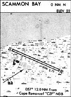
| Runways: | 10/28 |
| Longest Runway: | 10/28 is 3001 ft (915 m) long |
| Runways with an Instrument Approach: |
SCM Airport Runway Details
| Runway 10/28 | 3001 ft x 75 ft (915 m x 23 m) | |
| Runway Length Source: | 3RD PARTY SURVEY as of 06/20/2013 | |
| Surface: | Dirt - Good condition - No special surface treatment | |
| Runway Edge Lights: | Medium Intensity | |
Runway 10 |
Runway 28 |
|
Elevation: |
12.4 | 17.6 |
Latitude: |
61-50-46.2254N | 61-50-34.4739N |
Longitude: |
165-34-54.1945W | 165-33-56.8283W |
|
Runway True Alignment: |
113 | 293 |
Glide Path Angle: |
0.0 degrees | 0.0 degrees |
Traffic Pattern: |
Left | Right |
Runway Markings Type: |
Nonstandard (other than numbers only) | Nonstandard (other than numbers only) |
Object at End: |
BRUSH | |
Object Height: |
3 | |
Distance from End: |
0 | |
Object Centerline Offset: |
80 ft. left of centerline | |
REIL: |
No |
Services
Airframe Repair: |
None |
Powerplant Repair: |
None |
Bottled Oxygen: |
None |
Bulk Oxygen: |
None |
Landing Fees: |
No |
Maps & Diagrams
SCM Sectional
Flight Planning
at skyvector.com
at skyvector.com