Location
Latitude: |
47-32-50.1400N (47.547261) |
Longitude: |
116-11-20.6300W (-116.189064) |
Elevation: |
2227.0 feet MSL (679 m MSL) |
Magnetic Variation: |
13.7 E (as of April 2024 from WMM2020 model) |
Time Zone: |
UTC -8.0 (Standard Time) UTC -7.0 (Daylight Savings Time) |
From City: |
03 N.M. W of Kellogg, Idaho |
Found On: |
Great Falls Chart |
FAA Region: |
ANM |
Contacts
Manager: |
Publicly owned: |
| JOHN HANSEN 700 BANK ST, SUITE 120 WALLACE 83873 208-512-0532 |
SHOSHONE COUNTY 700 BANK STREET WALLACE, ID 83873-2348 208-752-3331 |
Operations
Airport Status: |
Operational |
Facility Use: |
Public |
Type: |
Airport |
Activation Date: |
04/1961 |
Control tower: |
No |
Attendance (Months/Days/Hours): |
Months/Days/Hours ALL/ALL/DALGT |
Boundary ARTCC: |
ZSE (Seattle) |
Responsible ARTCC: |
ZSE (Seattle) |
Lighting Schedule: |
SEE RMK |
Segmented Circle Indicator: |
Yes |
Traffic Pattern Altitude (MSL): |
3227 feet (984 m) |
NOTAMs Facility: |
BOI |
NOTAM-D Service: |
Yes |
International Airport of Entry: |
No |
Customs Landing Rights: |
No |
Military Landing Rights: |
Yes |
Civil/Military Joint Use: |
No |
Based Aircraft
| Single Engine: | 12 |
| Multi Engine: | 1 |
| GA Helicopters: | 1 |
| Ultralights: | 1 |
Annual Operations (as of 09/30/2021)
| Total Operations: | 7500 | |
| Air Taxi: | 750 | 10.0% |
| GA Local: | 1200 | 16.0% |
| GA Itinerant: | 5500 | 73.3% |
| Military Aircraft: | 50 | 0.7% |
Communications
| CTAF: | 122.800 |
| Unicom: | 122.800 |
Fixed Based Operators (FBOs) & Fuel
(Click on a business for detail)
Please help us keep this information up to date. This is a FREE SERVICE just like everything else on Airport Guide! If you see that a business needs to be added, modified, or deleted please fill out our Update Form.
To add, modify, or delete a business click here.
Please help us keep this information up to date. This is a FREE SERVICE just like everything else on Airport Guide! If you see that a business needs to be added, modified, or deleted please fill out our Update Form.
Area Code: 208 |
| Business Name | Frequency | Phone | Fuel Grade |
|---|---|---|---|
| Shoshone Air Service
Update FBO info |
Unicom 122.8 | 786-5381 |
Flight Service Stations
| Primary | Alternate | |
| FSS on Field: | N | |
| FSS Name (ID): | Boise(BOI) | |
| Frequency: | ||
| Toll Free Phone: | 1-800-WX-BRIEF |
Instrument Procedures / Charts
Terminal Procedures are only available for airports in several countries with more being added all the time. If you are looking for a specific country's charts, please send an email to support(at)airportguide.com stating the country name. This will be used to prioritize the implementation.
Navigation Aids (Navaids) near S83
| Dist (NM) | ID | Morse Code | Name | Type | Freq | True Hdg | Mag Hdg |
|---|---|---|---|---|---|---|---|
| 22.7 | MLP | _ _ . _ . . . _ _ . | Mullan Pass | VOR-DME | 117.80 | 103 | 89 |
| 28.9 | COE | _ . _ . _ _ _ . | Coeur D'alene | VOR-DME | 108.80 | 298 | 284 |
| 33.3 | LEN | . _ . . . _ . | Post Falls | NDB | 347 | 290 | 276 |
| 46.4 | SFF | . . . . . _ . . . _ . | Spokane/Felts Field | VOT | 114.00 | 280 | 266 |
| 47.1 | SZT | . . . _ _ . . _ | Sandpoe | NDB | 264 | 341 | 327 |
| 51.6 | CRK | _ . _ . . _ . _ . _ | Canyon | NDB | 388 | 279 | 265 |
| 53.3 | LYI | . _ . . _ . _ _ . . | Libby | NDB | 414 | 31 | 17 |
| 54.3 | GEG | _ _ . . _ _ . | Spokane Intl | VOT | 109.60 | 274 | 260 |
| 55.9 | DPY | _ . . . _ _ . _ . _ _ | Deer Park | NDB | 365 | 297 | 283 |
| 58.2 | GEG | _ _ . . _ _ . | Spokane | VORTAC | 115.50 | 271 | 257 |
| 59.7 | SKA | . . . _ . _ . _ | Fairchild | TACAN | 111.40 | 274 | 260 |
| 67.3 | PUW | . _ _ . . . _ . _ _ | Pullman | VOR-DME | 117.15 | 219 | 205 |
| 75.3 | MQG | _ _ _ _ . _ _ _ . | Nez Perce | VOR-DME | 114.45 | 201 | 187 |
| 77.3 | SAK | . . . . _ _ . _ | Smith Lake | NDB | 515 | 63 | 50 |
| 77.8 | INE | . . _ . . | Konna | NDB | 521 | 109 | 96 |
| 85.3 | ION | . . _ _ _ _ . | Ione | NDB | 379 | 325 | 311 |
| 89.6 | IDQ | . . _ . . _ _ . _ | Cottonwood | DME | 115.65 | 187 | 173 |
| 90.3 | FCA | . . _ . _ . _ . . _ | Kalispell | VOR-DME | 113.20 | 62 | 49 |
| 90.5 | U6 | Creston | NDB | 360 | 352 | 338 | |
| 94.0 | MSO | _ _ . . . _ _ _ | Missoula | VOR-DME | 112.80 | 113 | 100 |
Nearby Airports with Fuel
Notices to Airmen (NOTAMS)
Remarks
| A110-1 | FOR CD CTC SEATTLE ARTCC AT 253-351-3694. |
| A52-25 | RY 25 +80 FT TREES AT 1700 FT ON CNTRLN; +40 FT POLE & TRRN ON CNTRLN 700 FT FM RY END; +63 FT SIGN AT 1900 FT ON CNTRLN. |
| A57-25 | RWY 25 APPROACH SLOPE 16:1 TO DISPLACED THRESHOLD. |
| A81-APT | ACVT MIRL RY 07/25 - CTAF. |
Runways
Runway Summary
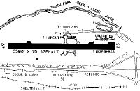
| Runways: | 07/25 |
| Longest Runway: | 07/25 is 5316 ft (1620 m) long |
| Runways with an Instrument Approach: |
S83 Airport Runway Details
| Runway 07/25 | 5316 ft x 75 ft (1620 m x 23 m) | |
| Runway Length Source: | OWNER as of 05/14/2010 | |
| Surface: | Asphalt - Excellent condition - No special surface treatment | |
| Runway Edge Lights: | Medium Intensity | |
Runway Weight Bearing Capacity (in thousands of pounds) |
||
| Single Wheel Landing Gear: | 14.0 | |
Runway 07 |
Runway 25 |
|
Elevation: |
2208.0 | 2227.0 |
Latitude: |
47-32-49.5200N | 47-32-50.7600N |
Longitude: |
116-11-59.3600W | 116-10-41.9000W |
Glide Path Angle: |
0.0 degrees | 0.0 degrees |
Traffic Pattern: |
Right | Left |
Runway Markings Type: |
Basic | Basic |
Runway Markings Condition: |
Good | Good |
Object at End: |
TREE | TREE |
Object Height: |
50 | 55 |
Distance from End: |
345 | 500 |
Object Centerline Offset: |
125 ft. right of centerline | 100 ft. left of centerline |
Threshold Elevation: |
2227.0 | |
Displaced Threshold: |
335 | |
Threshold Latitude: |
47-32-50.6800N | |
Threshold Longitude: |
116-10-46.7800W |
Services
Airframe Repair: |
Major |
Powerplant Repair: |
Major |
Bottled Oxygen: |
None |
Bulk Oxygen: |
None |
Fuel Available: |
100LL, Jet A+ |
Landing Fees: |
No |
Parking: |
Tiedowns available |
Maps & Diagrams
S83 Sectional
Flight Planning
at skyvector.com
at skyvector.com