Location
Latitude: |
37-56-08.3480N (37.935652) |
Longitude: |
091-48-48.7710W (-91.813548) |
Elevation: |
987.0 feet MSL (301 m MSL) |
Magnetic Variation: |
0.7 W (as of April 2024 from WMM2020 model) |
Time Zone: |
UTC -6.0 (Standard Time) UTC -5.0 (Daylight Savings Time) |
From City: |
03 N.M. SW of Rolla, Missouri |
Found On: |
Kansas City Chart |
FAA Region: |
ACE |
Contacts
Manager: |
Privately owned: |
| MAXINE DICKMAN 13720 COUNTY ROAD 7040 ROLLA, MO 65401 573-341-2994 |
MAXINE DICKMAN FOSMARK 13720 COUNTY ROAD 7040 ROLLA, MO 65401 573-341-2994 |
Operations
Airport Status: |
Operational |
Facility Use: |
Public |
Type: |
Airport |
Activation Date: |
10/1963 |
Control tower: |
No |
Attendance (Months/Days/Hours): |
Months/Days/Hours Unattended |
Boundary ARTCC: |
ZKC (Kansas City) |
Responsible ARTCC: |
ZKC (Kansas City) |
Segmented Circle Indicator: |
No |
Traffic Pattern Altitude (MSL): |
1987 feet (606 m) |
NOTAMs Facility: |
COU |
NOTAM-D Service: |
Yes |
International Airport of Entry: |
No |
Customs Landing Rights: |
No |
Military Landing Rights: |
Yes |
Civil/Military Joint Use: |
No |
Based Aircraft
| Single Engine: | 3 |
Annual Operations (as of 12/31/2021)
| Total Operations: | 320 | |
| GA Local: | 300 | 93.8% |
| GA Itinerant: | 20 | 6.2% |
Communications
| CTAF: | 122.800 |
| Unicom: | 122.800 |
- APCH/DEP SVC PRVDD BY KANSAS CITY ARTCC ON FREQS 128.35/284.675 (MAPLES RCAG).
Fixed Based Operators (FBOs) & Fuel
(Click on a business for detail)
Please help us keep this information up to date. This is a FREE SERVICE just like everything else on Airport Guide! If you see that a business needs to be added, modified, or deleted please fill out our Update Form.
To add, modify, or delete a business click here.
Please help us keep this information up to date. This is a FREE SERVICE just like everything else on Airport Guide! If you see that a business needs to be added, modified, or deleted please fill out our Update Form.
Area Code: 573 |
| Business Name | Frequency | Phone | Fuel Grade |
|---|
Flight Service Stations
| Primary | Alternate | |
| FSS on Field: | N | |
| FSS Name (ID): | Columbia(COU) | |
| Frequency: | ||
| Toll Free Phone: | 1-800-WX-BRIEF |
Instrument Procedures / Charts
| Page Type | Page Name | Volume | Action Since Last Cycle |
|---|
Terminal Procedures are only available for airports in several countries with more being added all the time. If you are looking for a specific country's charts, please send an email to support(at)airportguide.com stating the country name. This will be used to prioritize the implementation.
Navigation Aids (Navaids) near RLA
| Dist (NM) | ID | Morse Code | Name | Type | Freq | True Hdg | Mag Hdg |
|---|---|---|---|---|---|---|---|
| 14.0 | VIH | . . . _ . . . . . . | Vichy | VOR-DME | 117.70 | 21 | 22 |
| 19.3 | TBN | _ _ . . . _ . | Forney | VOR | 110.00 | 233 | 234 |
| 19.8 | BHN | _ . . . . . . . _ . | Buckhorn | NDB | 391 | 224 | 225 |
| 20.7 | MAP | _ _ . _ . _ _ . | Maples | TACAN | 113.40 | 176 | 177 |
| 35.6 | UUV | . . _ . . _ . . . _ | Sullivan | NDB | 356 | 59 | 60 |
| 36.3 | AIZ | . _ . . _ _ . . | Kaiser | NDB | 377 | 285 | 285 |
| 37.8 | SHY | . . . . . . . _ . _ _ | Sunshine | VOR-DME | 108.40 | 279 | 279 |
| 38.7 | JE | . _ _ _ . | Algoa | NDB | 397 | 341 | 342 |
| 43.0 | JEF | . _ _ _ . . . _ . | Jefferson City | VOT | 112.00 | 337 | 338 |
| 45.6 | IEB | . . . _ . . . | Lebanon | NDB | 414 | 241 | 241 |
| 55.9 | COU | _ . _ . _ _ _ . . _ | Columbia | VOR-DME | 110.20 | 340 | 341 |
| 56.7 | MNF | _ _ _ . . . _ . | Mountain View | NDB | 365 | 175 | 176 |
| 60.4 | FTZ | . . _ . _ _ _ . . | Foristell | VORTAC | 110.80 | 40 | 41 |
| 63.6 | UNO | . . _ _ . _ _ _ | Pomona | NDB | 335 | 183 | 184 |
| 64.0 | HUW | . . . . . . _ . _ _ | Hutton | DME | 111.6 | 183 | 184 |
| 64.9 | SU | . . . . . _ | Snoop | NDB | 326 | 49 | 50 |
| 66.4 | PRI | . _ _ . . _ . . . | Perrine | NDB | 367 | 98 | 99 |
| 69.1 | FES | . . _ . . . . . | Festus | NDB | 269 | 76 | 77 |
| 70.0 | SUS | . . . . . _ . . . | Spirit Of St Louis | VOT | 112.20 | 51 | 52 |
| 72.2 | HLV | . . . . . _ . . . . . _ | Hallsville | VORTAC | 114.20 | 348 | 349 |
Nearby Airports with Fuel
Notices to Airmen (NOTAMS)
Remarks
| A110*G | THIS AIRPORT HAS BEEN SURVEYED BY THE NATIONAL GEODETIC SURVEY. |
| A110-1 | WILDLIFE ON & INVOF ARPT. |
| A110-3 | RY 09/27 LINE OF SIGHT OBSTRUCTED BY GRADE CHANGE IN RY. |
| A110-4 | TALL BRUSH LOCATED 70-125 FT SOUTH OF RY, FM RY 09 THLD TO ACCESS TWY. |
| A110-5 | FOR CD CTC KANSAS CITY ARTCC AT 913-254-8508. |
| A33-09/27 | RWY 9/27 PAVEMENT CRACKING, VEGETATION GROWING IN CRACKS. |
| A42-09 | MARKINGS FADED. |
| A42-09 1 | RWY 09 NSTD BSC MARKINGS: INCORRECT SPACING OF DESIGNATION MARKINGS RY 09. |
| A42-27 | MARKINGS FADED. |
| A42-27 1 | NSTD BSC MARKNGS; INCORRECT LENGTH; WIDTH; COLOR & SPACING OF DSPLCD THLD & DESIGNATION MARKINGS RY 27. |
| A57-27 | RY 27 9:1TO DSPLCD THLD; +30 FT TREE, 340 FT FM DSPLCD THLD, 50 FT R. |
| A58-09 | RWY 09 20-25 FT TREES, BRUSH 0-30 FT FM RWY END, 70 FT RIGHT. |
| A58-27 | RWY 27 1-55 FT TREES; FENCES; POWERLINES; BRUSHES & HIGH GND 0-200 FT FM RWY END LEFT & RIGHT. |
| A82 | UNICOM UNMON. |
Runways
Runway Summary
| Runways: | 09/27 |
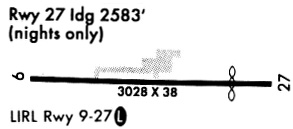
| Longest Runway: | 09/27 is 3028 ft (923 m) long |
| Runways with an Instrument Approach: |
RLA Airport Runway Details
| Runway 09/27 | 3028 ft x 38 ft (923 m x 12 m) | |
| Surface: | Asphalt - Good condition - No special surface treatment | |
Runway 09 |
Runway 27 |
|
Elevation: |
956.0 | 964.0 |
Latitude: |
37-56-09.2280N | 37-56-07.5300N |
Longitude: |
091-49-07.6070W | 091-48-29.8720W |
|
Runway True Alignment: |
093 | 273 |
Glide Path Angle: |
0.0 degrees | 0.0 degrees |
Traffic Pattern: |
Left | Left |
Runway Markings Type: |
Nonstandard (other than numbers only) | Nonstandard (other than numbers only) |
Runway Markings Condition: |
Poor | Poor |
Object at End: |
TREES | TREES |
Object Height: |
28 | 55 |
Distance from End: |
600 | 200 |
Object Centerline Offset: |
117 ft. right of centerline | 125 ft. left and right of centerline |
Threshold Elevation: |
964.0 | |
Displaced Threshold: |
445 | |
Threshold Latitude: |
37-56-07.7800N | |
Threshold Longitude: |
091-48-35.4200W |
Services
Fuel Available: |
100LL, MOGAS |
Landing Fees: |
No |
Maps & Diagrams
RLA Sectional
Flight Planning
at skyvector.com
at skyvector.com