


Location
Latitude: |
56-55-24.9573N (56.923599) |
Longitude: |
023-58-15.9595E (23.9711) |
Elevation: |
36 feet MSL (11 m MSL) |
Magnetic Variation: |
8.8 E (as of April 2024 from WMM2020 model) |
Time Zone: |
UTC +2.0 (Standard Time) UTC +3.0 (Daylight Savings Time) |
Contacts
Manager: |
: |
Operations
Airport Status: |
Operational |
Facility Use: |
Public |
Type: |
Airport |
Traffic Pattern Altitude (MSL): |
1036 feet (316 m) |
Based Aircraft
Annual Operations (as of )
Communications
| CTAF: | 118.2 |
| CTAF: | 124.8 |
| CTAF: | 120 |
| CTAF: | 119.8 |
| CTAF: | 124.8 |
| CTAF: | 119.8 |
| CTAF: | 125.4 |
| CTAF: | 124.8 |
| CTAF: | 127.8 |
| TWR: | 118.1 |
| Riga Apron: | 131.6 |
| Riga Ground: | 118.8 |
| APP: | 129.925 |
| ATIS: | 121.2 |
| MISC: | 122.4 |
| MISC: | 122.4 |
| MISC: | 122.4 |
| MISC: | 120.7 |
| MISC: | 116.3 |
| MISC: | 123.9 |
| MISC: | 125.4 |
| MISC: | 120.7 |
| MISC: | 125 |
| MISC: | 119.6 |
| MISC: | 114.1 |
| MISC: | 118.6 |
| MISC: | 122.6 |
| MISC: | 122.4 |
| MISC: | 122.6 |
Fixed Based Operators (FBOs) & Fuel
(Click on a business for detail)
Please help us keep this information up to date. This is a FREE SERVICE just like everything else on Airport Guide! If you see that a business needs to be added, modified, or deleted please fill out our Update Form.
To add, modify, or delete a business click here.
Please help us keep this information up to date. This is a FREE SERVICE just like everything else on Airport Guide! If you see that a business needs to be added, modified, or deleted please fill out our Update Form.
| Business Name | Frequency | Phone | Fuel Grade |
|---|
Flight Service Stations
| Primary | Alternate | |
| FSS on Field: | ||
| FSS Name (ID): | ||
| Frequency: | ||
| Toll Free Phone: |
Instrument Procedures / Charts
Terminal Procedures are only available for airports in several countries with more being added all the time. If you are looking for a specific country's charts, please send an email to support(at)airportguide.com stating the country name. This will be used to prioritize the implementation.
Navigation Aids (Navaids) near RIX
| Dist (NM) | ID | Morse Code | Name | Type | Freq | True Hdg | Mag Hdg |
|---|---|---|---|---|---|---|---|
| 0.3 | RIA | Riga | VOR-DME | 112.05 | 230 | 221 | |
| 1.6 | RIX | Riga | VOR-DME | 113.70 | 184 | 175 | |
| 64.8 | SQQ | Siauliai | TACAN | 116.30 | 197 | 188 | |
| 65.3 | SAU | Siauliai | VOR-DME | 115.20 | 196 | 187 | |
| 71.3 | PA | Pajuostis | NDB | 515 | 167 | 158 | |
| 78.6 | LBN | Trakshi | VOR-DME | 112.90 | 95 | 86 | |
| 83.0 | VNT | Ventspils | VOR-DME | 113.60 | 289 | 281 | |
| 91.0 | PRN | Parnu | VOR-DME | 115.90 | 9 | 360 | |
| 91.2 | KRS | Kuressaare | VOR-DME | 112.40 | 329 | 320 | |
| 92.3 | R | Parnu | NDB | 376 | 10 | 1 | |
| 93.5 | WA | Kuressaare | NDB | 350 | 330 | 321 | |
| 96.0 | RC | Parnu | NDB | 425 | 11 | 2 | |
| 97.8 | LIE | Liepaja | VOR-DME | 112.30 | 256 | 248 |
Nearby Airports with Fuel
| Dist (NM) | Name (Airport IDs) | True Hdg | Mag Hdg | Fuel Grade |
|---|
Notices to Airmen (NOTAMS)
Remarks
No remarks for this landing facility
Runways
Runway Summary
| Runways: | 18/36 |
| Longest Runway: | 18/36 is 10499 ft (3200 m) long |
| Runways with an Instrument Approach: |
RIX Airport Runway Details
| Runway 18/36 | 10499 ft x 148 ft (3200 m x 45 m) | |
| Runway Edge Lights: | Yes Intensity | |
Runway 18 |
Runway 36 |
|
Elevation: |
31 | 37 |
Latitude: |
56.93510055541 | 56.90643692016 |
Longitude: |
23.973100662231 | 23.968345642089 |
|
Runway True Alignment: |
185 | 5 |
Glide Path Angle: |
0.0 degrees | 0.0 degrees |
REIL: |
Yes | Yes |
Threshold Elevation: |
31 | 37 |
Services
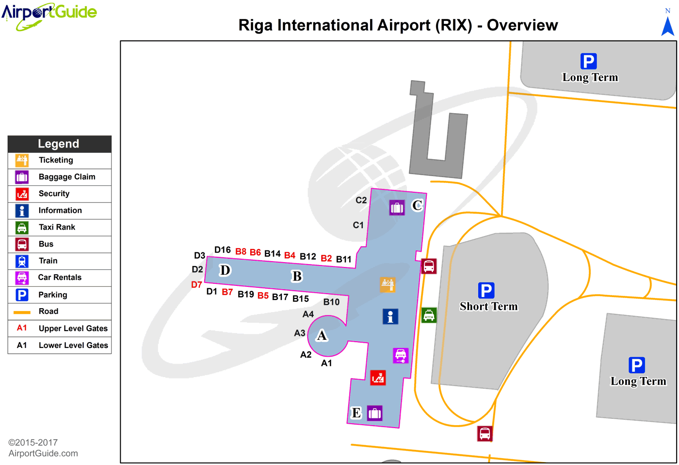
Maps & Diagrams
RIX Sectional
Flight Planning
at skyvector.com
at skyvector.com
