Location
Latitude: |
36-46-26.1670N (36.773935) |
Longitude: |
090-19-29.4700W (-90.324853) |
Elevation: |
330.8 feet MSL (101 m MSL) |
Magnetic Variation: |
1.7 W (as of April 2024 from WMM2020 model) |
Time Zone: |
UTC -6.0 (Standard Time) UTC -5.0 (Daylight Savings Time) |
From City: |
03 N.M. E of Poplar Bluff, Missouri |
Found On: |
St Louis Chart |
FAA Region: |
ACE |
Contacts
Manager: |
Publicly owned: |
| GARY PRIDE 101 OAK STREET POPLAR BLUFF, MO 63901 573-686-8669 |
CITY OF POPLAR BLUFF 101 OAK ST POPLAR BLUFF, MO 63901 573-686-8620 |
Operations
Airport Status: |
Operational |
Facility Use: |
Public |
Type: |
Airport |
Activation Date: |
04/1940 |
Control tower: |
No |
Attendance (Months/Days/Hours): |
Months/Days/Hours ALL/ALL/0700-1600 |
Boundary ARTCC: |
ZME (Memphis) |
Responsible ARTCC: |
ZME (Memphis) |
Lighting Schedule: |
SEE RMK |
Segmented Circle Indicator: |
Yes |
Traffic Pattern Altitude (MSL): |
1331 feet (406 m) |
NOTAMs Facility: |
POF |
NOTAM-D Service: |
Yes |
International Airport of Entry: |
No |
Customs Landing Rights: |
No |
Military Landing Rights: |
No |
Civil/Military Joint Use: |
No |
Based Aircraft
| Single Engine: | 23 |
| Multi Engine: | 7 |
| GA Helicopters: | 1 |
Annual Operations (as of 12/31/2020)
| Total Operations: | 16700 | |
| Air Taxi: | 1500 | 9.0% |
| GA Local: | 3000 | 18.0% |
| GA Itinerant: | 12000 | 71.9% |
| Military Aircraft: | 200 | 1.2% |
Communications
| CTAF: | 123.000 |
| Unicom: | 123.000 |
| ASOS: | 124.225 (573-776-1686) |
- APCH/DEP SVC PRVDD BY MEMPHIS ARTCC ON FREQS 120.075/289.4 (WALNUT RIDGE RCAG).
Fixed Based Operators (FBOs) & Fuel
(Click on a business for detail)
Please help us keep this information up to date. This is a FREE SERVICE just like everything else on Airport Guide! If you see that a business needs to be added, modified, or deleted please fill out our Update Form.
To add, modify, or delete a business click here.
Please help us keep this information up to date. This is a FREE SERVICE just like everything else on Airport Guide! If you see that a business needs to be added, modified, or deleted please fill out our Update Form.
Area Code: 573 |
| Business Name | Frequency | Phone | Fuel Grade |
|---|---|---|---|
| Aeroflite, Inc.
Update FBO info |
Unicom 123.0 | 686-4892 | 100LL, Jet A |
Flight Service Stations
| Primary | Alternate | |
| FSS on Field: | N | |
| FSS Name (ID): | Saint Louis(STL) | |
| Frequency: | ||
| Toll Free Phone: | 1-800-WX-BRIEF |
Instrument Procedures / Charts
FAA Terminal Procedures valid from 0901Z 03/21/24 to 0901Z 04/18/24.
There are various types of charts available for an airport. They are listed in the Page Type column. Here is a legend for those types:
APD - Airport Diagram
DP - Departure Procedure Charts
HOT - Hot Spots
IAP - Instrument Approach Procedure Charts
MIN - Minimums
STAR - Standard Terminal Arrival Charts
| Page Type | Page Name | Volume | Action Since Last Cycle |
|---|---|---|---|
| IAP | RNAV (GPS) RWY 18 | NC-3 | |
| IAP | RNAV (GPS) RWY 36 | NC-3 | |
| MIN | ALTERNATE MINIMUMS | NC-3 | |
| MIN | TAKEOFF MINIMUMS | NC-3 |
Terminal Procedures are only available for airports in several countries with more being added all the time. If you are looking for a specific country's charts, please send an email to support(at)airportguide.com stating the country name. This will be used to prioritize the implementation.
Navigation Aids (Navaids) near POF
| Dist (NM) | ID | Morse Code | Name | Type | Freq | True Hdg | Mag Hdg |
|---|---|---|---|---|---|---|---|
| 6.3 | FD | . . _ . _ . . | Earli | NDB | 278 | 181 | 183 |
| 23.8 | MAW | _ _ . _ . _ _ | Malden | TACAN | 111.20 | 123 | 125 |
| 41.5 | CG | _ . _ . _ _ . | Dutch | NDB | 248 | 45 | 47 |
| 44.6 | TNZ | _ _ . _ _ . . | Lawrence County | NDB | 227 | 220 | 222 |
| 45.2 | CGI | _ . _ . _ _ . . . | Cape Girardeau | DME | 112.9 | 52 | 54 |
| 46.7 | CHQ | _ . _ . . . . . _ _ . _ | Charleston | NDB | 208 | 84 | 86 |
| 50.1 | ARG | . _ . _ . _ _ . | Walnut Ridge | VORTAC | 114.50 | 217 | 218 |
| 52.7 | GOJ | _ _ . _ _ _ . _ _ _ | Gosnell | VOR | 111.80 | 159 | 161 |
| 54.1 | FAM | . . _ . . _ _ _ | Farmington | VORTAC | 115.70 | 4 | 6 |
| 55.4 | JBR | . _ _ _ _ . . . . _ . | Jonesboro | VOR-DME | 115.85 | 193 | 195 |
| 55.6 | CIR | _ . _ . . . . _ . | Cairo | NDB | 397 | 71 | 73 |
| 59.6 | PRI | . _ _ . . _ . . . | Perrine | NDB | 367 | 355 | 357 |
| 66.5 | DYR | _ . . _ . _ _ . _ . | Dyersburg | TACAN | 116.80 | 132 | 134 |
| 67.8 | MNF | _ _ _ . . . _ . | Mountain View | NDB | 365 | 281 | 282 |
| 70.2 | UC | . . _ _ . _ . | Obion | NDB | 212 | 113 | 115 |
| 72.8 | CNG | _ . _ . _ . _ _ . | Cunningham | VOR-DME | 113.10 | 78 | 80 |
| 75.9 | HUW | . . . . . . _ . _ _ | Hutton | DME | 111.6 | 274 | 275 |
| 76.0 | UNO | . . _ _ . _ _ _ | Pomona | NDB | 335 | 275 | 276 |
| 79.5 | COO | _ . _ . _ _ _ _ _ _ | Covington | NDB | 326 | 153 | 155 |
| 82.4 | BDD | _ . . . _ . . _ . . | Bellgrade | NDB | 254 | 73 | 75 |
Nearby Airports with Fuel
Notices to Airmen (NOTAMS)
Remarks
| A110-1 | CROP DUSTING ACFT ON & INVOF ARPT FM MARCH TO AUGUST. |
| A110-2 | FOR CD CTC MEMPHIS ARTCC AT 901-368-8453/8449. |
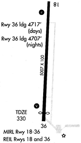
| A57-36 | RWY 36 APCH SLOPE 28:1 TO DSPLCD THLD. |
| A81-APT | MIRL RWY 18/36, SS-SR; CTAF TO CHG INTST; 7 CLICKS FOR HIGH, 5 CLICKS FOR MED OR LWR INTST. VASI RWY 36 & PAPI RWY 18 - CTAF. |
Runways
Runway Summary
| Runways: | 18/36 |
| Longest Runway: | 18/36 is 5008 ft (1526 m) long |
| Runways with an Instrument Approach: | 36 |
POF Airport Runway Details
| Runway 18/36 | 5008 ft x 100 ft (1526 m x 30 m) | |
| Runway Length Source: | 3RD PARTY SURVEY as of 09/09/2019 | |
| Surface: | Concrete - Good condition - No special surface treatment | |
| Runway Edge Lights: | Medium Intensity | |
Runway Weight Bearing Capacity (in thousands of pounds) |
||
| Single Wheel Landing Gear: | 16.0 | |
Runway 18 |
Runway 36 |
|
Elevation: |
330.5 | 327.5 |
Latitude: |
36-46-50.9168N | 36-46-01.4169N |
Longitude: |
090-19-28.7279W | 090-19-30.2113W |
|
Runway True Alignment: |
181 | 001 |
ILS Type: |
SDF | |
Glide Path Angle: |
3.0 degrees | 3.0 degrees |
Traffic Pattern: |
Left | Left |
Runway Markings Type: |
Nonprecision Instrument | Nonprecision Instrument |
Runway Markings Condition: |
Good | Good |
Object at End: |
TREES | TREES |
Object Height: |
64 | 44 |
Distance from End: |
1161 | 962 |
Object Centerline Offset: |
370 ft. left of centerline | 100 ft. right of centerline |
Visual Glide Slope Indicators: |
4-Light PAPI On Left Side Of Runway | 4-Box VASI On Left Side Of Runway |
REIL: |
Yes | Yes |
Threshold Crossing Height: |
30 | 40 |
Threshold Elevation: |
328.0 | |
Displaced Threshold: |
290 | |
Threshold Latitude: |
36-46-04.2789N | |
Threshold Longitude: |
090-19-30.1250W |
Services
Airframe Repair: |
None |
Powerplant Repair: |
None |
Bottled Oxygen: |
None |
Bulk Oxygen: |
None |
Fuel Available: |
100LL |
Landing Fees: |
No |
Parking: |
Tiedowns available |
Maps & Diagrams
POF Sectional
Flight Planning
at skyvector.com
at skyvector.com