
Location
Latitude: |
45-37-50.16N (45.6306) |
Longitude: |
008-43-41.196E (8.72811) |
Elevation: |
768 feet MSL (234 m MSL) |
Magnetic Variation: |
3.4 E (as of April 2024 from WMM2020 model) |
Time Zone: |
UTC +1.0 (Standard Time) UTC +2.0 (Daylight Savings Time) |
Contacts
Manager: |
: |
Operations
Airport Status: |
Operational |
Facility Use: |
Public |
Type: |
Airport |
Traffic Pattern Altitude (MSL): |
1768 feet (539 m) |
Based Aircraft
Annual Operations (as of )
Communications
| TWR: | 119 |
| CLNC DEL: | 120.9 |
| GND: | 121.9 |
| MILANO APP: | 132.7 |
| MILANO DEP: | 126.75 |
| ATIS: | 120.025 |
Fixed Based Operators (FBOs) & Fuel
(Click on a business for detail)
Please help us keep this information up to date. This is a FREE SERVICE just like everything else on Airport Guide! If you see that a business needs to be added, modified, or deleted please fill out our Update Form.
To add, modify, or delete a business click here.
Please help us keep this information up to date. This is a FREE SERVICE just like everything else on Airport Guide! If you see that a business needs to be added, modified, or deleted please fill out our Update Form.
| Business Name | Frequency | Phone | Fuel Grade |
|---|---|---|---|
| Aviapartner
Website Update FBO info |
131.600 MHz | +39 (0)2 748 66409 |
Flight Service Stations
| Primary | Alternate | |
| FSS on Field: | ||
| FSS Name (ID): | ||
| Frequency: | ||
| Toll Free Phone: |
Instrument Procedures / Charts
Terminal Procedures are only available for airports in several countries with more being added all the time. If you are looking for a specific country's charts, please send an email to support(at)airportguide.com stating the country name. This will be used to prioritize the implementation.
Navigation Aids (Navaids) near MXP
| Dist (NM) | ID | Morse Code | Name | Type | Freq | True Hdg | Mag Hdg |
|---|---|---|---|---|---|---|---|
| 0.8 | MAL | Malpensa | VOR-DME | 111.20 | 20 | 17 | |
| 4.7 | CAM | Cameri | TACAN | 115.00 | 219 | 216 | |
| 5.2 | MAL | Malpensa | NDB | 364 | 166 | 163 | |
| 12.2 | CAM | Cameri | NDB | 323 | 185 | 182 | |
| 12.3 | SRN | Saronno | NDB | 330 | 85 | 82 | |
| 12.4 | SRN | Saronno | VOR-DME | 113.70 | 85 | 82 | |
| 12.7 | NOV | Novara | NDB | 292 | 167 | 164 | |
| 13.5 | RMG | Romagnano | NDB | 337 | 269 | 266 | |
| 25.1 | LIN | Linate | VOR-DME | 112.25 | 113 | 110 | |
| 27.3 | BLA | Biella Cerrione | NDB | 350 | 248 | 245 | |
| 27.6 | BLA | Biella Cerrione | VOR-DME | 116.10 | 252 | 249 | |
| 29.2 | LIN | Linate | NDB | 386 | 125 | 122 | |
| 33.0 | TZO | Trezzo | VOR-DME | 117.25 | 97 | 94 | |
| 33.1 | TZO | Trezzo | NDB | 345 | 97 | 94 | |
| 41.2 | BEG | BERGAMO | VOR-DME | 11495 | 86 | 83 | |
| 41.3 | VOG | Voghera | VOR-DME | 115.50 | 165 | 162 | |
| 41.3 | VOG | Voghera | NDB | 334 | 165 | 162 | |
| 42.0 | COD | Codogno | NDB | 401 | 125 | 122 | |
| 46.7 | ORI | Orio Al Serio | NDB | 377 | 88 | 84 | |
| 51.7 | CSL | Caselle | VOR-DME | 116.75 | 241 | 238 |
Nearby Airports with Fuel
| Dist (NM) | Name (Airport IDs) | True Hdg | Mag Hdg | Fuel Grade |
|---|---|---|---|---|
| 41.4 | Lodrino Air Base Airport (LSML) |
15 | 12 | Jet A1 |
Notices to Airmen (NOTAMS)
Remarks
No remarks for this landing facility
Runways
Runway Summary
| Runways: | 17L/35R 17R/35L |
| Longest Runway: | 17L/35R is 12861 ft (3920 m) long |
| Runways with an Instrument Approach: |
MXP Airport Runway Details
| Runway 17L/35R | 12861 ft x 197 ft (3920 m x 60 m) | |
| Runway Edge Lights: | Yes Intensity | |
Runway 17L |
Runway 35R |
|
Elevation: |
745 | 691 |
Latitude: |
45.65039825439 | 45.61569976806 |
Longitude: |
8.7284097671508 | 8.7375001907348 |
|
Runway True Alignment: |
169.6 | 349.6 |
Glide Path Angle: |
0.0 degrees | 0.0 degrees |
REIL: |
Yes | Yes |
Threshold Elevation: |
745 | 691 |
Displaced Threshold: |
3094 |
| Runway 17R/35L | 12861 ft x 197 ft (3920 m x 60 m) | |
| Runway Edge Lights: | Yes Intensity | |
Runway 17R |
Runway 35L |
|
Elevation: |
764 | 696 |
Latitude: |
45.64550018310 | 45.61080169677 |
Longitude: |
8.7187299728393 | 8.7278099060058 |
|
Runway True Alignment: |
169.6 | 349.6 |
Glide Path Angle: |
0.0 degrees | 0.0 degrees |
REIL: |
Yes | Yes |
Threshold Elevation: |
764 | 696 |
Displaced Threshold: |
1329 |
Services
Fuel Available: |
Jet A1 |
Maps & Diagrams
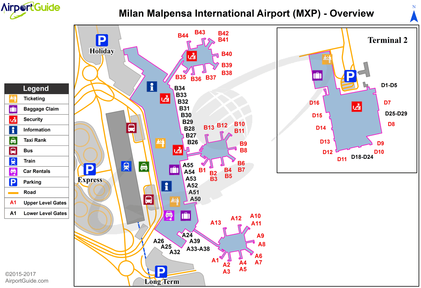
MXP Sectional
Flight Planning
at skyvector.com
at skyvector.com
