Location
Latitude: |
32-29-07.5110N (32.48542) |
Longitude: |
091-46-15.8390W (-91.771066) |
Elevation: |
82.7 feet MSL (25 m MSL) |
Magnetic Variation: |
0.5 W (as of April 2024 from WMM2020 model) |
Time Zone: |
UTC -6.0 (Standard Time) UTC -5.0 (Daylight Savings Time) |
From City: |
01 N.M. NW of Rayville, Louisiana |
Found On: |
Memphis Chart |
FAA Region: |
ASW |
Contacts
Manager: |
Publicly owned: |
| CHARLIE ADAMS 12 ELLIS LANE RAYVILLE, LA 71269 318-235-0187 |
CITY OF RAYVILLE PO BOX 878 RAYVILLE, LA 71269 318-728-2011 |
Operations
Airport Status: |
Operational |
Facility Use: |
Public |
Type: |
Airport |
Activation Date: |
09/1950 |
Control tower: |
No |
Attendance (Months/Days/Hours): |
Months/Days/Hours Unattended |
Boundary ARTCC: |
ZFW (Fort Worth) |
Responsible ARTCC: |
ZFW (Fort Worth) |
Lighting Schedule: |
SEE RMK |
Segmented Circle Indicator: |
No |
Traffic Pattern Altitude (MSL): |
1083 feet (330 m) |
NOTAMs Facility: |
DRI |
NOTAM-D Service: |
Yes |
International Airport of Entry: |
No |
Customs Landing Rights: |
No |
Military Landing Rights: |
Yes |
Civil/Military Joint Use: |
No |
Based Aircraft
| Single Engine: | 23 |
| Multi Engine: | 4 |
| GA Helicopters: | 2 |
| Gliders: | 1 |
Annual Operations (as of 09/27/2023)
| Total Operations: | 18000 | |
| GA Local: | 12000 | 66.7% |
| GA Itinerant: | 6000 | 33.3% |
Communications
| CTAF: | 122.800 |
| Unicom: | 122.800 |
| Approach: | MONROE 126.9 FORT WORTH ARTCC |
| Departure: | MONROE 126.9 FORT WORTH ARTCC |
- APCH/DEP CTL SVC PRVDD BY FORT WORTH ARTCC (ZFW) ON FREQS 126.325/346.25 (MONROE RCAG) WHEN MONROE APCH CTL (MLU) CLSD.
Fixed Based Operators (FBOs) & Fuel
(Click on a business for detail)
Please help us keep this information up to date. This is a FREE SERVICE just like everything else on Airport Guide! If you see that a business needs to be added, modified, or deleted please fill out our Update Form.
To add, modify, or delete a business click here.
Please help us keep this information up to date. This is a FREE SERVICE just like everything else on Airport Guide! If you see that a business needs to be added, modified, or deleted please fill out our Update Form.
Area Code: 318 |
| Business Name | Frequency | Phone | Fuel Grade |
|---|
Flight Service Stations
| Primary | Alternate | |
| FSS on Field: | N | |
| FSS Name (ID): | De Ridder(DRI) | |
| Frequency: | ||
| Toll Free Phone: | 1-800-WX-BRIEF |
Instrument Procedures / Charts
FAA Terminal Procedures valid from 0901Z 03/21/24 to 0901Z 04/18/24.
There are various types of charts available for an airport. They are listed in the Page Type column. Here is a legend for those types:
APD - Airport Diagram
DP - Departure Procedure Charts
HOT - Hot Spots
IAP - Instrument Approach Procedure Charts
MIN - Minimums
STAR - Standard Terminal Arrival Charts
| Page Type | Page Name | Volume | Action Since Last Cycle |
|---|---|---|---|
| IAP | RNAV (GPS) RWY 18 | SC-4 | |
| IAP | RNAV (GPS) RWY 36 | SC-4 | |
| IAP | VOR/DME-A | SC-4 | |
| MIN | TAKEOFF MINIMUMS | SC-4 |
Terminal Procedures are only available for airports in several countries with more being added all the time. If you are looking for a specific country's charts, please send an email to support(at)airportguide.com stating the country name. This will be used to prioritize the implementation.
Navigation Aids (Navaids) near M79
| Dist (NM) | ID | Morse Code | Name | Type | Freq | True Hdg | Mag Hdg |
|---|---|---|---|---|---|---|---|
| 4.6 | MRK | _ _ . _ . _ . _ | Molly Ridge | NDB | 338 | 184 | 185 |
| 13.5 | MLU | _ _ . _ . . . . _ | Monroe | VORTAC | 117.20 | 278 | 278 |
| 17.0 | ML | _ _ . _ . . | Sabar | NDB | 392 | 263 | 263 |
| 17.1 | BQP | _ . . . _ _ . _ . _ _ . | Bastrop | NDB | 329 | 340 | 340 |
| 35.9 | BLE | _ . . . . _ . . . | Lake Providence | NDB | 278 | 54 | 55 |
| 40.4 | TKH | _ _ . _ . . . . | Tallulah | NDB | 344 | 110 | 111 |
| 41.7 | TUF | _ . . _ . . _ . | Stuckey | NDB | 350 | 263 | 263 |
| 42.0 | ROQ | . _ . _ _ _ _ _ . _ | Ruston | NDB | 368 | 280 | 280 |
| 51.2 | JBL | . _ _ _ _ . . . . _ . . | Hodge | NDB | 256 | 250 | 250 |
| 53.5 | HAH | . . . . . _ . . . . | Natchez-Adams County | NDB | 388 | 152 | 153 |
| 55.3 | SWB | . . . . _ _ _ . . . | Sawmill | VOR-DME | 113.75 | 236 | 236 |
| 57.3 | HEZ | . . . . . _ _ . . | Natchez | VOR-DME | 110.00 | 155 | 156 |
| 64.7 | MON | _ _ _ _ _ _ . | Monticello | DME | 111.6 | 2 | 3 |
| 67.4 | ELD | . . _ . . _ . . | El Dorado | VOR-DME | 115.50 | 313 | 313 |
| 68.1 | EL | . . _ . . | Lados | NDB | 418 | 315 | 315 |
| 69.0 | MTQ | _ _ _ _ _ . _ | Metcalf | NDB | 359 | 34 | 35 |
| 69.8 | RYB | . _ . _ . _ _ _ . . . | Raymond | NDB | 375 | 98 | 99 |
| 73.8 | GLH | _ _ . . _ . . . . . . | Greenville | VOR-DME | 114.25 | 32 | 33 |
| 76.6 | JH | . _ _ _ . . . . | Brenz | NDB | 260 | 92 | 93 |
| 81.2 | JAN | . _ _ _ . _ _ . | Jackson | VORTAC | 112.60 | 88 | 89 |
Nearby Airports with Fuel
Notices to Airmen (NOTAMS)
Remarks
| A110-1 | ROAD 367 FT & RR TRACK 467 FT FM APCH END RY 36. |
| A110-2 | RY 18/36 40-80 FT TREES WEST SIDE OF RY PENETRATE TRANSITION SLOPE. |
| A110-4 | FOR CD CTC MONROE APCH AT 318-327-5641, IF UNAVBL, CTC FORT WORTH ARTCC AT 817-858-7584. |
| A17 | FOR SVCS AFT HRS CALL 318-235-3177. |
| A57-36 | APCH SLP 12:1 TO DSPLCD THLD. |
| A81-APT | DUSK-DAWN. MIRL RY 18/36, REIL RYS 18 & 36 PRESET LOW INTST DUSK-DAWN; TO INCR INTST ACTVT - CTAF. |
| E111 | PRE-DATES THE ACT. |
Runways
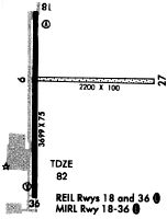
Runway Summary
| Runways: | 18/36 |
| Longest Runway: | 18/36 is 3998 ft (1219 m) long |
| Runways with an Instrument Approach: |
M79 Airport Runway Details
| Runway 18/36 | 3998 ft x 75 ft (1219 m x 23 m) | |
| Runway Length Source: | 3RD PARTY SURVEY as of 08/10/2007 | |
| Surface: | Asphalt - Good condition - No special surface treatment | |
| Runway Edge Lights: | Medium Intensity | |
Runway Weight Bearing Capacity (in thousands of pounds) |
||
| Single Wheel Landing Gear: | 12.0 | |
Runway 18 |
Runway 36 |
|
Elevation: |
82.3 | 81.0 |
Latitude: |
32-29-26.9634N | 32-28-47.4295N |
Longitude: |
091-46-19.7324W | 091-46-21.2501W |
|
Runway True Alignment: |
182 | 002 |
Glide Path Angle: |
3.0 degrees | 3.0 degrees |
Traffic Pattern: |
Left | Left |
Runway Markings Type: |
Nonprecision Instrument | Nonprecision Instrument |
Runway Markings Condition: |
Good | Good |
Object at End: |
TREES | TREES |
Object Height: |
83 | 27 |
Distance from End: |
2006 | 465 |
Object Centerline Offset: |
0 ft. left and right of centerline | |
Visual Glide Slope Indicators: |
2-Light PAPI On Left Side Of Runway | 2-Light PAPI On Left Side Of Runway |
REIL: |
Yes | Yes |
Centerline Lights: |
No | No |
Threshold Crossing Height: |
50 | 50 |
Threshold Elevation: |
81.4 | |
Displaced Threshold: |
291 | |
Threshold Latitude: |
32-28-50.3095N | |
Threshold Longitude: |
091-46-21.1481W |
Services
Airframe Repair: |
None |
Powerplant Repair: |
None |
Bottled Oxygen: |
None |
Bulk Oxygen: |
None |
Fuel Available: |
100LL |
Landing Fees: |
No |
Parking: |
Tiedowns available |
Maps & Diagrams
M79 Sectional
Flight Planning
at skyvector.com
at skyvector.com