Location
Latitude: |
41-07-34.3660N (41.126213) |
Longitude: |
100-41-01.1510W (-100.683653) |
Elevation: |
2777.0 feet MSL (846 m MSL) |
Magnetic Variation: |
5.3 E (as of April 2024 from WMM2020 model) |
Time Zone: |
UTC -6.0 (Standard Time) UTC -5.0 (Daylight Savings Time) |
From City: |
03 N.M. E of North Platte, Nebraska |
Found On: |
Omaha Chart |
FAA Region: |
ACE |
Contacts
Manager: |
Publicly owned: |
| MR. SAM SEAFELDT 5400 E LEE BIRD DR NORTH PLATTE, NE 69101 (308) 530-0607 |
NORTH PLATTE AIRPORT AUTH PO BOX 1517 NORTH PLATTE, NE 69103 308-532-1900 |
Operations
Airport Status: |
Operational |
Facility Use: |
Public |
Type: |
Airport |
Control tower: |
No |
Attendance (Months/Days/Hours): |
Months/Days/Hours ALL/ALL/0600-2300 |
Boundary ARTCC: |
ZDV (Denver) |
Responsible ARTCC: |
ZDV (Denver) |
Lighting Schedule: |
SEE RMK |
Segmented Circle Indicator: |
Yes |
Traffic Pattern Altitude (MSL): |
3777 feet (1151 m) |
NOTAMs Facility: |
LBF |
NOTAM-D Service: |
Yes |
International Airport of Entry: |
No |
Customs Landing Rights: |
No |
Military Landing Rights: |
Yes |
Civil/Military Joint Use: |
No |
Aircraft Rescue and Firefighting: |
Class I ARFF Index: A Air Carrier Service: Scheduled Certification Date: 05/1990 |
Based Aircraft
| Single Engine: | 33 |
| Multi Engine: | 1 |
| Jet Engine: | 1 |
| GA Helicopters: | 2 |
Annual Operations (as of 12/31/2022)
| Total Operations: | 25050 | |
| Commercial: | 1250 | 5.0% |
| Air Taxi: | 3000 | 12.0% |
| GA Local: | 6000 | 24.0% |
| GA Itinerant: | 14600 | 58.3% |
| Military Aircraft: | 200 | 0.8% |
Communications
| CTAF: | 123.000 |
| Unicom: | 123.000 |
| ASOS: | 118.425 (308-534-1617) |
- APCH/DEP CTL SVC PRVDD BY DENVER ARTCC (ZDV) ON FREQS 132.7/226.675 (NORTH PLATTE RCAG).
- CLEARANCE DELIVERY PRVDD BY DENVER ARTCC ON FREQ 132.7.
Fixed Based Operators (FBOs) & Fuel
(Click on a business for detail)
Please help us keep this information up to date. This is a FREE SERVICE just like everything else on Airport Guide! If you see that a business needs to be added, modified, or deleted please fill out our Update Form.
To add, modify, or delete a business click here.
Please help us keep this information up to date. This is a FREE SERVICE just like everything else on Airport Guide! If you see that a business needs to be added, modified, or deleted please fill out our Update Form.
Area Code: 308 |
| Business Name | Frequency | Phone | Fuel Grade |
|---|---|---|---|
| Trego/Dugan Aviation
Update FBO info |
Unicom 123.0 | 532-5864 | 100LL, Jet A |
Flight Service Stations
| Primary | Alternate | |
| FSS on Field: | N | |
| FSS Name (ID): | Columbus(OLU) | |
| Frequency: | ||
| Toll Free Phone: | 1-800-WX-BRIEF |
Instrument Procedures / Charts
FAA Terminal Procedures valid from 0901Z 03/21/24 to 0901Z 04/18/24.
There are various types of charts available for an airport. They are listed in the Page Type column. Here is a legend for those types:
APD - Airport Diagram
DP - Departure Procedure Charts
HOT - Hot Spots
IAP - Instrument Approach Procedure Charts
MIN - Minimums
STAR - Standard Terminal Arrival Charts
| Page Type | Page Name | Volume | Action Since Last Cycle |
|---|---|---|---|
| APD | AIRPORT DIAGRAM | NC-2 | |
| IAP | ILS OR LOC RWY 30 | NC-2 | |
| IAP | RNAV (GPS) RWY 12 | NC-2 | |
| IAP | RNAV (GPS) RWY 30 | NC-2 | |
| IAP | RNAV (GPS) RWY 35 | NC-2 | |
| IAP | VOR RWY 35 | NC-2 | |
| MIN | ALTERNATE MINIMUMS | NC-2 | |
| MIN | TAKEOFF MINIMUMS | NC-2 |
Terminal Procedures are only available for airports in several countries with more being added all the time. If you are looking for a specific country's charts, please send an email to support(at)airportguide.com stating the country name. This will be used to prioritize the implementation.
Navigation Aids (Navaids) near LBF
| Dist (NM) | ID | Morse Code | Name | Type | Freq | True Hdg | Mag Hdg |
|---|---|---|---|---|---|---|---|
| 5.5 | LBF | . _ . . _ . . . . . _ . | North Platte | VOR-DME | 117.40 | 211 | 206 |
| 6.1 | LB | . _ . . _ . . . | Panbe | NDB | 416 | 124 | 119 |
| 31.6 | DWL | _ . . . _ _ . _ . . | Willow | NDB | 353 | 118 | 113 |
| 34.4 | OZB | _ _ _ _ _ . . _ . . . | Cozad | VOR | 109.00 | 116 | 111 |
| 41.1 | RRX | . _ . . _ . _ . . _ | Darr | NDB | 326 | 114 | 109 |
| 41.8 | HCT | . . . . _ . _ . _ | Hayes Center | VORTAC | 117.70 | 195 | 190 |
| 49.4 | SAE | . . . . _ . | Searle | VOR-DME | 110.20 | 269 | 263 |
| 49.7 | CUZ | _ . _ . . . _ _ _ . . | Custer County | VOR-DME | 108.20 | 64 | 59 |
| 49.8 | GGF | _ _ . _ _ . . . _ . | Grant | NDB | 359 | 252 | 246 |
| 51.4 | TDD | _ _ . . _ . . | Thedford | VOR-DME | 108.60 | 358 | 353 |
| 54.8 | CSB | _ . _ . . . . _ . . . | Harry Strunk | NDB | 389 | 153 | 148 |
| 55.5 | MCK | _ _ _ . _ . _ . _ | Mc Cook | VOR-DME | 115.30 | 175 | 170 |
| 57.1 | MCK | _ _ _ . _ . _ . _ | Mc Cook | FAN MARKER | 173 | 168 | |
| 77.0 | OKS | _ _ _ _ . _ . . . | Oshkosh | NDB | 233 | 282 | 276 |
| 78.1 | OIN | _ _ _ . . _ . | Oberlin | NDB | 341 | 175 | 170 |
| 79.4 | BUB | _ . . . . . _ _ . . . | Burwell | NDB | 377 | 60 | 55 |
| 79.8 | EAR | . . _ . _ . | Kearney | VOR | 111.20 | 106 | 101 |
| 80.3 | CNP | _ . _ . _ . . _ _ . | Chappell | NDB | 383 | 268 | 262 |
| 81.0 | EA | . . _ | Anoke | NDB | 422 | 111 | 106 |
| 83.7 | ODX | _ _ _ _ . . _ . . _ | Ord | NDB | 356 | 68 | 63 |
Nearby Airports with Fuel
Notices to Airmen (NOTAMS)
Remarks
| A110-1 | WATERFOWL ON & INVOF ARPT. |
| A110-2 | FOR CD CTC DENVER ARTCC ON FREQ. IF UNA, CTC FSS ON FREQ VIA RCO. IF UNA, CTC DENVER ARTCC AT 303-651-4257. |
| A16 | AFT HRS EMERG, CALL OPNS SUPVR 308-530-6948. |
| A26 | PPR 24 HRS FOR UNSKED ACR OPNS WITH MORE THAN 30 PSGR SEATS CALL AMGR 308-530-6948, ARFF INDEX B EQUIP PRVD. |
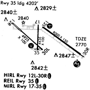
| A57-35 | RWY 35 APCH RATIO 36:1 TO DSPLCD THLD. |
| A81-APT | ACTVT HIRL RWY 12/30; MIRL RWY 17/35; PAPI RWY 12 & 30; VASI RWY 35; MALSR RWY 30 & REIL RWY 35 - CTAF. |
| E147 | ALL CAT D ACFT (WITH SPDS OF 141-166 KTS) OPERATING ON RWY 12/30 MUST MNTN A TPA OF 1500 FT WHEN IN THE TFC PAT. |
Runways
Runway Summary
| Runways: | 12/30 17/35 |
| Longest Runway: | 12/30 is 8001 ft (2439 m) long |
| Runways with an Instrument Approach: | 30 |
LBF Airport Runway Details
| Runway 12/30 | 8001 ft x 150 ft (2439 m x 46 m) | |
| Runway Length Source: | 3RD PARTY SURVEY as of 08/08/2020 | |
| Surface: | Concrete - Excellent condition - Saw-cut or plastic grooved | |
| Runway Pavement Class: | 33 /R/D/W/T | |
| Runway Edge Lights: | High Intensity | |
Runway Weight Bearing Capacity (in thousands of pounds) |
||
| Single Wheel Landing Gear: | 75.0 | |
| Dual Wheel Landing Gear: | 110.0 | |
| Dual Tandem Wheel Landing Gear: | 190.0 | |
Runway 12 |
Runway 30 |
|
Elevation: |
2777.0 | 2769.0 |
Latitude: |
41-07-56.0712N | 41-07-09.7306N |
Longitude: |
100-41-24.8042W | 100-40-00.1265W |
|
Runway True Alignment: |
126 | 306 |
ILS Type: |
ILS | |
Glide Path Angle: |
3.0 degrees | 3.0 degrees |
Traffic Pattern: |
Left | Left |
Runway Markings Type: |
Precision Instrument | Precision Instrument |
Runway Markings Condition: |
Good | Good |
Visual Glide Slope Indicators: |
4-Light PAPI On Left Side Of Runway | 4-Light PAPI On Left Side Of Runway |
Approach Light System: |
1,400 Foot Medium Intensity Approach Lighting System With Runway Alignment Indicator Lights | |
Threshold Crossing Height: |
55 | 55 |
Declared Distances |
||
Take Off Run Avbl. (TORA): |
8001 | 8001 |
Take Off Distance Avbl. (TODA): |
8001 | 8001 |
Actual Stop Dist. Avbl. (ASDA): |
8001 | 8001 |
Landing Dist. Avbl. (LDA): |
8001 | 8001 |
| Runway 17/35 | 4436 ft x 100 ft (1352 m x 30 m) | |
| Runway Length Source: | 3RD PARTY SURVEY as of 08/08/2020 | |
| Surface: | Concrete - Excellent condition - No special surface treatment | |
| Runway Pavement Class: | 22 /R/B/W/T | |
| Runway Edge Lights: | Medium Intensity | |
Runway Weight Bearing Capacity (in thousands of pounds) |
||
| Single Wheel Landing Gear: | 28.0 | |
| Dual Wheel Landing Gear: | 48.0 | |
| Dual Tandem Wheel Landing Gear: | 86.0 | |
Runway 17 |
Runway 35 |
|
Elevation: |
2775.7 | 2774.1 |
Latitude: |
41-07-58.9096N | 41-07-15.0922N |
Longitude: |
100-41-34.3014W | 100-41-35.4144W |
|
Runway True Alignment: |
181 | 001 |
Glide Path Angle: |
0.0 degrees | 3.0 degrees |
Traffic Pattern: |
Left | Left |
Runway Markings Type: |
Nonprecision Instrument | Nonprecision Instrument |
Runway Markings Condition: |
Good | Good |
Object at End: |
ROAD | TREE |
Object Height: |
21 | 27 |
Distance from End: |
850 | 675 |
Visual Glide Slope Indicators: |
4-Box VASI On Left Side Of Runway | |
REIL: |
Yes | |
Threshold Crossing Height: |
36 | |
Threshold Elevation: |
2774.8 | |
Displaced Threshold: |
301 | |
Threshold Latitude: |
41-07-18.0651N | |
Threshold Longitude: |
100-41-35.3398W | |
Declared Distances |
||
Take Off Run Avbl. (TORA): |
4436 | 4436 |
Take Off Distance Avbl. (TODA): |
4436 | 4436 |
Actual Stop Dist. Avbl. (ASDA): |
4135 | 4436 |
Landing Dist. Avbl. (LDA): |
4135 | 4135 |
Services
Airframe Repair: |
None |
Powerplant Repair: |
None |
Bottled Oxygen: |
None |
Bulk Oxygen: |
None |
Fuel Available: |
100LL |
Landing Fees: |
No |
Parking: |
Tiedowns available |
Maps & Diagrams
LBF Sectional
Flight Planning
at skyvector.com
at skyvector.com