Location
Latitude: |
34-34-03.7720N (34.567714) |
Longitude: |
098-24-59.8920W (-98.416637) |
Elevation: |
1110.3 feet MSL (338 m MSL) |
Magnetic Variation: |
3.7 E (as of April 2024 from WMM2020 model) |
Time Zone: |
UTC -6.0 (Standard Time) UTC -5.0 (Daylight Savings Time) |
From City: |
02 N.M. S of Lawton, Oklahoma |
Found On: |
Dallas-Ft Worth Chart |
FAA Region: |
ASW |
Contacts
Manager: |
Publicly owned: |
| BARBARA MCNALLY 3401 S 11TH ST LAWTON, OK 73501 580-353-4869 |
CITY OF LAWTON BOX 531 LAWTON, OK 73502 580-581-3301 |
Operations
Airport Status: |
Operational |
Facility Use: |
Public |
Type: |
Airport |
Activation Date: |
12/1948 |
Control tower: |
Yes |
Attendance (Months/Days/Hours): |
Months/Days/Hours ALL/MON-FRI/0530-2000 |
Boundary ARTCC: |
ZFW (Fort Worth) |
Responsible ARTCC: |
ZFW (Fort Worth) |
Lighting Schedule: |
SEE RMK |
Segmented Circle Indicator: |
Yes |
Traffic Pattern Altitude (MSL): |
2110 feet (643 m) |
NOTAMs Facility: |
LAW |
NOTAM-D Service: |
Yes |
International Airport of Entry: |
No |
Customs Landing Rights: |
No |
Military Landing Rights: |
Yes |
Civil/Military Joint Use: |
No |
Aircraft Rescue and Firefighting: |
Class I ARFF Index: B Air Carrier Service: Scheduled Certification Date: 05/1973 |
Based Aircraft
| Single Engine: | 42 |
| Multi Engine: | 4 |
| Jet Engine: | 4 |
| GA Helicopters: | 3 |
Annual Operations (as of 12/31/2022)
| Total Operations: | 24289 | |
| Commercial: | 1505 | 6.2% |
| Air Taxi: | 54 | 0.2% |
| GA Local: | 5679 | 23.4% |
| GA Itinerant: | 1727 | 7.1% |
| Military Aircraft: | 15324 | 63.1% |
Communications
| CTAF: | 119.900 |
| Unicom: | 122.950 |
| Tower: | LAWTON 119.9 257.8 Hrs: 0800-1900 |
| Ground: | 121.9 |
| Approach: | FORT SILL 120.55 120.55 |
| Departure: | FORT SILL 120.55 120.55 |
| ATIS: | 120.75 Hrs: 24 |
| ASOS: | 120.75 (580-581-1351) |
| EMERG: | 121.5 |
| EMERG: | 243.0 |
Fixed Based Operators (FBOs) & Fuel
(Click on a business for detail)
Please help us keep this information up to date. This is a FREE SERVICE just like everything else on Airport Guide! If you see that a business needs to be added, modified, or deleted please fill out our Update Form.
To add, modify, or delete a business click here.
Please help us keep this information up to date. This is a FREE SERVICE just like everything else on Airport Guide! If you see that a business needs to be added, modified, or deleted please fill out our Update Form.
Area Code: 580 |
| Business Name | Frequency | Phone | Fuel Grade |
|---|---|---|---|
| Regional Air
Update FBO info |
Unicom 122.95 | 355-7701 | 100LL, Jet A (Avfuel) MOGAS (independent) |
Flight Service Stations
| Primary | Alternate | |
| FSS on Field: | N | |
| FSS Name (ID): | Mc Alester(MLC) | |
| Frequency: | ||
| Toll Free Phone: | 1-800-WX-BRIEF |
Instrument Procedures / Charts
FAA Terminal Procedures valid from 0901Z 03/21/24 to 0901Z 04/18/24.
There are various types of charts available for an airport. They are listed in the Page Type column. Here is a legend for those types:
APD - Airport Diagram
DP - Departure Procedure Charts
HOT - Hot Spots
IAP - Instrument Approach Procedure Charts
MIN - Minimums
STAR - Standard Terminal Arrival Charts
| Page Type | Page Name | Volume | Action Since Last Cycle |
|---|---|---|---|
| APD | AIRPORT DIAGRAM | SC-1 | |
| IAP | ILS OR LOC RWY 35 | SC-1 | |
| IAP | RNAV (GPS) RWY 35 | SC-1 | |
| IAP | VOR RWY 35 | SC-1 | |
| MIN | ALTERNATE MINIMUMS | SC-1 | |
| MIN | RADAR MINIMUMS | SC-1 | |
| MIN | TAKEOFF MINIMUMS | SC-1 |
Terminal Procedures are only available for airports in several countries with more being added all the time. If you are looking for a specific country's charts, please send an email to support(at)airportguide.com stating the country name. This will be used to prioritize the implementation.
Navigation Aids (Navaids) near LAW
| Dist (NM) | ID | Morse Code | Name | Type | Freq | True Hdg | Mag Hdg |
|---|---|---|---|---|---|---|---|
| 2.5 | PFL | . _ _ . . . _ . . _ . . | Post | NDB | 425 | 14 | 10 |
| 4.3 | LAW | . _ . . . _ . _ _ | Lawton | VOR-DME | 116.85 | 177 | 173 |
| 12.8 | OFZ | _ _ _ . . _ . _ _ . . | Trail | NDB | 388 | 3 | 359 |
| 12.8 | FSI | . . _ . . . . . . | Trail | FAN MARKER | 3 | 359 | |
| 27.1 | DUC | _ . . . . _ _ . _ . | Duncan | DME | 111 | 113 | 109 |
| 35.3 | SHP | . . . . . . . . _ _ . | Sheppard | TACAN | 110.80 | 185 | 181 |
| 35.9 | SPS | . . . . _ _ . . . . | Wichita Falls | VORTAC | 112.70 | 194 | 190 |
| 36.6 | HBR | . . . . _ . . . . _ . | Hobart | VORTAC | 111.80 | 299 | 295 |
| 39.5 | ICF | . . _ . _ . . . _ . | Madison | NDB | 296 | 182 | 178 |
| 42.6 | LTS | . _ . . _ . . . | Altus | VORTAC | 109.80 | 277 | 273 |
| 47.3 | SKB | . . . _ . _ _ . . . | Scotland | NDB | 344 | 184 | 180 |
| 55.9 | BFV | _ . . . . . _ . . . . _ | Burns Flat | VORTAC | 110.00 | 316 | 312 |
| 59.3 | PVJ | . _ _ . . . . _ . _ _ _ | Pauls Valley | NDB | 384 | 81 | 78 |
| 59.7 | RG | . _ . _ _ . | Gally | NDB | 350 | 42 | 39 |
| 61.9 | IRW | . . . _ . . _ _ | Will Rogers | VORTAC | 114.10 | 39 | 36 |
| 61.9 | OUN | _ _ _ . . _ _ . | Norman | NDB | 370 | 48 | 45 |
| 62.7 | OKC | _ _ _ _ . _ _ . _ . | Oklahoma Will Rgs W | VOT | 112.15 | 39 | 36 |
| 64.7 | HMY | . . . . _ _ _ . _ _ | Muldrow | NDB | 512 | 64 | 61 |
| 65.4 | ADM | . _ _ . . _ _ | Ardmore | VORTAC | 116.70 | 108 | 105 |
| 65.5 | BZ | _ . . . _ _ . . | Fossi | NDB | 393 | 324 | 320 |
Nearby Airports with Fuel
Notices to Airmen (NOTAMS)
Remarks
| A110*G | THIS AIRPORT HAS BEEN SURVEYED BY THE NATIONAL GEODETIC SURVEY. |
| A110-1 | WHEN ATCT CLSD ARFF AVBL THROUGH FORT SILL APCH. |
| A110-3 | BIRDS ON & INVOF ARPT. |
| A110-4 | TWY F CLSD EXC ACFT MORE THAN 110000 LBS. 12 HR PPR - 580-585-1321. |
| A110-5 | WHEN ATCT CLSD, FOR CD CTC FORT WORTH ARTCC AT 817-858-7584. |
| A16 | EXTENSION 301. |
| A26 | PPR FOR UNSKED PART 121 ACR OPS WITH MORE THAN 30 PAX SEATS - AMGR. |
| A81-APT | WHEN ATCT CLSD ACTVT MALSR RWY 35 - CTAF. HIRL RWY 17/35 PRESET MED INTST; INCR INTST - CTAF. |
| E111 | PRE DATES THE ACT. |
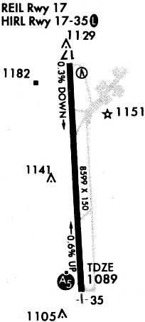
Runways
Runway Summary
| Runways: | 17/35 |
| Longest Runway: | 17/35 is 8599 ft (2621 m) long |
| Runways with an Instrument Approach: | 35 |
LAW Airport Runway Details
| Runway 17/35 | 8599 ft x 150 ft (2621 m x 46 m) | |
| Surface: | Concrete - Good condition - Wire comb or wire tine | |
| Runway Edge Lights: | High Intensity | |
Runway Weight Bearing Capacity (in thousands of pounds) |
||
| Single Wheel Landing Gear: | 45.0 | |
| Dual Wheel Landing Gear: | 179.0 | |
| Dual Tandem Wheel Landing Gear: | 344.0 | |
Runway 17 |
Runway 35 |
|
Elevation: |
1110.3 | 1070.1 |
Latitude: |
34-34-42.7880N | 34-33-17.8580N |
Longitude: |
098-25-01.7490W | 098-24-56.2250W |
|
Runway True Alignment: |
177 | 357 |
ILS Type: |
ILS | |
Glide Path Angle: |
4.0 degrees | 0.0 degrees |
Traffic Pattern: |
Left | Left |
Runway Markings Type: |
Precision Instrument | Precision Instrument |
Runway Markings Condition: |
Fair | Fair |
Object at End: |
POLE | |
Object Height: |
72 | |
Object Marked/Lighted?: |
Lighted | |
Distance from End: |
3100 | |
Object Centerline Offset: |
170 ft. right of centerline | |
Visual Glide Slope Indicators: |
4-Light PAPI On Right Side Of Runway | |
Approach Light System: |
1,400 Foot Medium Intensity Approach Lighting System With Runway Alignment Indicator Lights | |
REIL: |
Yes | |
Threshold Crossing Height: |
47 | |
Declared Distances |
||
Take Off Run Avbl. (TORA): |
8599 | 8599 |
Take Off Distance Avbl. (TODA): |
8599 | 8599 |
Actual Stop Dist. Avbl. (ASDA): |
8599 | 8599 |
Landing Dist. Avbl. (LDA): |
8599 | 8599 |
Services
Bottled Oxygen: |
None |
Bulk Oxygen: |
None |
Fuel Available: |
100LL, Jet A |
Landing Fees: |
No |
Parking: |
Hangars and tiedowns available |
Maps & Diagrams
LAW Sectional
Flight Planning
at skyvector.com
at skyvector.com