Location
Latitude: |
55-21-14.7000N (55.354083) |
Longitude: |
131-42-40.4000W (-131.711222) |
Elevation: |
92.4 feet MSL (28 m MSL) |
Magnetic Variation: |
17.8 E (as of April 2024 from WMM2020 model) |
Time Zone: |
UTC -9.0 (Standard Time) UTC -8.0 (Daylight Savings Time) |
From City: |
01 N.M. W of Ketchikan, Alaska |
Found On: |
Ketchikan Chart |
FAA Region: |
AAL |
Contacts
Manager: |
Publicly owned: |
| ALEX PUERA 1000 ARPT TERMINAL WAY KETCHIKAN, AK 99901 907-225-6800 |
ALASKA DOT&PF SOUTHCOAST REGION 6860 GLACIER HIGHWAY JUNEAU, AK 99801-7999 907-465-1786 |
Operations
Airport Status: |
Operational |
Facility Use: |
Public |
Type: |
Airport |
Activation Date: |
04/1973 |
Control tower: |
No |
Attendance (Months/Days/Hours): |
Months/Days/Hours ALL/ALL/0600-2130 |
Boundary ARTCC: |
ZAN (Anchorage) |
Responsible ARTCC: |
ZAN (Anchorage) |
Lighting Schedule: |
SEE RMK |
Segmented Circle Indicator: |
Yes |
Traffic Pattern Altitude (MSL): |
1092 feet (333 m) |
NOTAMs Facility: |
KTN |
NOTAM-D Service: |
Yes |
International Airport of Entry: |
No |
Customs Landing Rights: |
Yes |
Military Landing Rights: |
Yes |
Civil/Military Joint Use: |
No |
Aircraft Rescue and Firefighting: |
Class I ARFF Index: B Air Carrier Service: Scheduled Certification Date: 03/2005 |
Based Aircraft
| Single Engine: | 3 |
| Multi Engine: | 1 |
| Jet Engine: | 1 |
Annual Operations (as of 01/31/2019)
| Total Operations: | 15959 | |
| Commercial: | 5290 | 33.1% |
| Air Taxi: | 9789 | 61.3% |
| GA Local: | 350 | 2.2% |
| GA Itinerant: | 395 | 2.5% |
| Military Aircraft: | 135 | 0.8% |
Communications
| CTAF: | 123.600 |
| Approach: | ANCHORAGE ARTCC |
| Departure: | ANCHORAGE ARTCC |
| ATIS: | Hrs: 24. |
| ASOS: | 134.45 (907-247-8801) |
| AFIS: | 134.45 |
- APCH/DEP SVC PRVDD BY ANCHORAGE ARTCC ON FREQS 118.5/284.6 (ANNETTE ISLAND RCAG).
- KTN AFIS ON FREQUENCY 134.45. OPERATES SAME HRS AS KTN FSS, 0615-2115;OT JUNEAU FSS,
- COMMUNICATIONS PRVDD BY KETCHIKAN FSS ON FREQ 123.6 (CTAF).
Fixed Based Operators (FBOs) & Fuel
(Click on a business for detail)
Please help us keep this information up to date. This is a FREE SERVICE just like everything else on Airport Guide! If you see that a business needs to be added, modified, or deleted please fill out our Update Form.
To add, modify, or delete a business click here.
Please help us keep this information up to date. This is a FREE SERVICE just like everything else on Airport Guide! If you see that a business needs to be added, modified, or deleted please fill out our Update Form.
Area Code: 907 |
| Business Name | Frequency | Phone | Fuel Grade |
|---|---|---|---|
| Aero Services, Inc.
Website Update FBO info |
Unicom 122.95 | 247-5701 | 100LL, Jet A |
| Great Land FBO
Update FBO info |
Unicom 122.8 | 225-8888, 800-770-8800 | 100LL, Jet A |
Flight Service Stations
| Primary | Alternate | |
| FSS on Field: | Y | |
| FSS Name (ID): | Ketchikan(KTN) | Juneau (JNU) |
| Frequency: | ||
| Toll Free Phone: | LC225-9481 | 1-866-297-2236 |
Instrument Procedures / Charts
FAA Terminal Procedures valid from 0901Z 03/21/24 to 0901Z 04/18/24.
There are various types of charts available for an airport. They are listed in the Page Type column. Here is a legend for those types:
APD - Airport Diagram
DP - Departure Procedure Charts
HOT - Hot Spots
IAP - Instrument Approach Procedure Charts
MIN - Minimums
STAR - Standard Terminal Arrival Charts
| Page Type | Page Name | Volume | Action Since Last Cycle |
|---|---|---|---|
| APD | AIRPORT DIAGRAM | AK-1 | |
| IAP | ILS Y OR LOC Y RWY 11 | AK-1 | |
| IAP | ILS Z OR LOC Z RWY 11 | AK-1 | |
| IAP | LOC X RWY 11 | AK-1 | |
| IAP | RNAV (GPS) RWY 11 | AK-1 | |
| IAP | RNAV (GPS) RWY 29 | AK-1 | |
| IAP | RNAV (GPS)-B | AK-1 | |
| MIN | ALTERNATE MINIMUMS | AK-1 | |
| MIN | TAKEOFF MINIMUMS | AK-1 | |
| ODP | KETCHIKAN SIX (OBSTACLE) | AK-1 | |
| ODP | SKOWL TWO (OBSTACLE) | AK-1 |
Terminal Procedures are only available for airports in several countries with more being added all the time. If you are looking for a specific country's charts, please send an email to support(at)airportguide.com stating the country name. This will be used to prioritize the implementation.
Navigation Aids (Navaids) near KTN
| Dist (NM) | ID | Morse Code | Name | Type | Freq | True Hdg | Mag Hdg |
|---|---|---|---|---|---|---|---|
| 0.2 | ECH | . _ . _ . . . . . | Ketchikan | VOT | 111.00 | 22 | 4 |
| 1.0 | CMJ | _ . _ . _ _ . _ _ _ | Clam Cove | NDB | 396 | 135 | 117 |
| 17.4 | ICK | . . _ . _ . _ . _ | Nichols | NDB | 266 | 167 | 149 |
| 18.2 | ANN | . _ _ . _ . | Annette Island | VOR-DME | 117.10 | 165 | 147 |
| 48.4 | AKW | . _ _ . _ . _ _ | Klawock | NDB-DME | 229 | 286 | 268 |
| 77.3 | IPR | Prince Rupert | DME | 109.70 | 145 | 127 | |
| 79.1 | PR | . _ _ . . _ . | Prince Rupert | NDB | 218 | 145 | 127 |
| 80.6 | 1U | Masset | NDB | 278 | 190 | 172 | |
| 81.2 | LVD | . _ . . . . . _ _ . . | Level Island | VOR-DME | 116.50 | 325 | 307 |
| 81.3 | SQM | . . . _ _ . _ _ _ | Sumner Strait | NDB | 529 | 325 | 307 |
| 94.0 | FPN | . . _ . . _ _ . _ . | Fredericks Point | NDB | 372 | 337 | 319 |
Nearby Airports with Fuel
| Dist (NM) | Name (Airport IDs) | True Hdg | Mag Hdg | Fuel Grade |
|---|---|---|---|---|
| 48.3 | Klawock Airport (KLW PAKW AKW) |
286 | 268 | 100LL, Jet A |
| 49.5 | Craig Seaplane Base (CGA CGA) |
279 | 261 | 100LL |
| 71.3 | Wrangell Airport (WRG PAWG WRG) |
342 | 324 | 100LL, Jet A |
| 96.2 | Petersburg James A Johnson Airport (PSG PAPG PSG) |
335 | 317 | 100, Jet A |
Notices to Airmen (NOTAMS)
Remarks
| A110-1 | TRRN CAUSES TURB ON ARR & DEP ROUTES. |
| A110-13 | USCG HELI 55-21-27.6N/131-42-19.8W; INVOF KETCHIKAN INTL ARPT & SEAPLAN BASE; MED-VAC MISSIONS ONLY - POC COMMANDER CG DISTRICT 17, 709 W 9TH ST, RM 661. BOX 25517 JUNEAU, AK 99802 - 907-463-2247/2000. |
| A110-16 | WX CAMERAS AVBL ON INTERNET AT HTTPS://WEATHERCAMS.FAA.GOV |
| A110-17 | TWY C LGTS OTS INDEF. |
| A110-18 | PPR FOR LDG DURG UNATNDD HRS - FBO 907-531-9891 FOR ARNGMT & CALL OUT CHARGE. |
| A110-2 | ALERT: SPL ATC RULES PART 93 & STD VFR ARR & DEP PROC & PAT INFO - SEE REG NOTICE. |
| A110-21 | GA APRON; TWY C; NE SECTION OF MAIN APRON PCN 21/F/B/X/T. |
| A110-22 | DOCK W OF ARPT CLSD NOV 1 - APR 1; PPR OVNGT - AMGR; FERRY BTW ARPT & CITY OPR CONSLY WHEN ARPT ATNDD. |
| A110-4 | BIRDS ON & INVOF ARPT. |
| A110-5 | PRIOR TO OPS ON APRON/TWY ALL ACFT CTC KTN FSS & ADZ INTNS. |
| A110-6 | SFC COND RPRTS REFLECT CONDS WHILE ARPT ATNDD ONLY. |
| A110-7 | CTN AIR TAXI & BOATS IN HARBOR; FLOATING DEBRIS PSBL. |
| A110-8 | SNOW & ICE REMOVAL NA WHEN ARPT UNATTND. |
| A14 | ALEX PEURA |
| A23-11 | WX PMTG FOR LIGHT SINGLE/TWIN ENG. |
| A24 | LNDG FEE FOR GA ACFT UNDER 6000 LB & FLOAT PLANE USE OF SPB FLOAT. |
| A26 | ACR OPS MORE THAN 30 PAX NA IN EXCESS OF 15 MIN BFR OR AFT SKED ARR OR DEP WO PPR WITH AMGR & CFM ARFF SVC AVBL BFR LDG OR TKOF. |
| A30-11/29 | SAND USED TO ENHANCE FRICTION MAY NOT MEET FAA SPECS. |
| A43-11 | PAPI UNUSBL 5 DEGS LEFT AND RIGHT OF CNTRLN. |
| A43-29 | PAPI UNUSBL BYD 6 NM. |
| A70-FUEL-10 | 0LL FUEL AVBL SUMMER 0530-1930; WINTER 0630-2030 VIA 122.95 OR PH: 907-531-9891. |
| A76 | SKED ACR SVC AVBL; OTR TIMES PPR. |
| A81-APT | WHEN KTN FSS CLSD ACTVT MALSR RWY 11 & 29; HIRL RWY 11/29 - CTAF. PAPI RWY 11 & 29 ON CONSLY. |
| A81-BCN | WHEN KTN FSS CLSD ON CONSLY. |
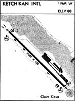
Runways
Runway Summary
| Runways: | 11/29 WNW/ESE |
| Longest Runway: | WNW/ESE is 9500 ft (2896 m) long |
| Runways with an Instrument Approach: | 11 |
KTN Airport Runway Details
| Runway 11/29 | 7500 ft x 150 ft (2286 m x 46 m) | |
| Runway Length Source: | 3RD PARTY SURVEY as of 05/11/2012 | |
| Surface: | Asphalt - Good condition - Saw-cut or plastic grooved | |
| Runway Pavement Class: | 49 /F/B/X/T | |
| Runway Edge Lights: | High Intensity | |
Runway Weight Bearing Capacity (in thousands of pounds) |
||
| Single Wheel Landing Gear: | 75.0 | |
| Dual Wheel Landing Gear: | 200.0 | |
| Dual Tandem Wheel Landing Gear: | 300.0 | |
Runway 11 |
Runway 29 |
|
Elevation: |
84.9 | 89.2 |
Latitude: |
55-21-41.0836N | 55-20-48.2679N |
Longitude: |
131-43-25.7763W | 131-41-54.9954W |
|
Runway True Alignment: |
136 | 316 |
ILS Type: |
ILS/DME | |
Glide Path Angle: |
3.0 degrees | 3.0 degrees |
Traffic Pattern: |
Right | |
Runway Markings Type: |
Precision Instrument | Precision Instrument |
Runway Markings Condition: |
Good | Good |
Object at End: |
TREES | |
Object Height: |
103 | |
Distance from End: |
3300 | |
Object Centerline Offset: |
0 ft. left and right of centerline | |
Visual Glide Slope Indicators: |
4-Light PAPI On Left Side Of Runway | 4-Light PAPI On Left Side Of Runway |
Runway Visual Range (RVR): |
Touchdown, Rollout | Touchdown, Rollout |
Approach Light System: |
1,400 Foot Medium Intensity Approach Lighting System With Runway Alignment Indicator Lights | 1,400 Foot Medium Intensity Approach Lighting System With Runway Alignment Indicator Lights |
Threshold Crossing Height: |
50 | 49 |
| Runway WNW/ESE | 9500 ft x 1500 ft (2896 m x 457 m) | |
| Surface: | Asphalt - Good condition - No special surface treatment | |
Runway ESE |
Runway WNW |
|
Glide Path Angle: |
0.0 degrees | 0.0 degrees |
Object Centerline Offset: |
0 ft. left and right of centerline |
Services
Airframe Repair: |
Minor |
Powerplant Repair: |
Minor |
Fuel Available: |
100, Jet A |
Parking: |
Hangars available |
Maps & Diagrams
KTN Sectional
Flight Planning
at skyvector.com
at skyvector.com