Location
Latitude: |
35-55-56.8370N (35.932455) |
Longitude: |
088-50-56.1850W (-88.84894) |
Elevation: |
358.4 feet MSL (109 m MSL) |
Magnetic Variation: |
2.7 W (as of April 2024 from WMM2020 model) |
Time Zone: |
UTC -6.0 (Standard Time) UTC -5.0 (Daylight Savings Time) |
From City: |
05 N.M. SE of Trenton, Tennessee |
Found On: |
Memphis Chart |
FAA Region: |
ASO |
Contacts
Manager: |
Publicly owned: |
| ART HOPPERS 56 AIRPORT RD MILAN, TN 38358 731-723-9596 |
GIBSON COUNTY ONE COURT SQUARE, SUITE 200 TRENTON, TN 38382 731-855-7613 |
Operations
Airport Status: |
Operational |
Facility Use: |
Public |
Type: |
Airport |
Control tower: |
No |
Attendance (Months/Days/Hours): |
Months/Days/Hours ALL/MON-SAT/0800-1630 |
Boundary ARTCC: |
ZME (Memphis) |
Responsible ARTCC: |
ZME (Memphis) |
Lighting Schedule: |
SS-SR |
Segmented Circle Indicator: |
Yes |
Traffic Pattern Altitude (MSL): |
1358 feet (414 m) |
NOTAMs Facility: |
MKL |
NOTAM-D Service: |
Yes |
International Airport of Entry: |
No |
Customs Landing Rights: |
No |
Military Landing Rights: |
Yes |
Civil/Military Joint Use: |
No |
Based Aircraft
| Single Engine: | 27 |
| Multi Engine: | 1 |
Annual Operations (as of 08/31/2019)
| Total Operations: | 9240 | |
| Air Taxi: | 1900 | 20.6% |
| GA Local: | 5420 | 58.7% |
| GA Itinerant: | 1800 | 19.5% |
| Military Aircraft: | 120 | 1.3% |
Communications
| CTAF: | 122.800 |
| Unicom: | 122.800 |
- APCH/DEP SVC PRVDD BY MEMPHIS ARTCC ON FREQS 134.65/316.15 (MCKELLAR RCAG).
Fixed Based Operators (FBOs) & Fuel
(Click on a business for detail)
Please help us keep this information up to date. This is a FREE SERVICE just like everything else on Airport Guide! If you see that a business needs to be added, modified, or deleted please fill out our Update Form.
To add, modify, or delete a business click here.
Please help us keep this information up to date. This is a FREE SERVICE just like everything else on Airport Guide! If you see that a business needs to be added, modified, or deleted please fill out our Update Form.
Area Code: 731 |
| Business Name | Frequency | Phone | Fuel Grade |
|---|
Flight Service Stations
| Primary | Alternate | |
| FSS on Field: | N | |
| FSS Name (ID): | Jackson(MKL) | |
| Frequency: | ||
| Toll Free Phone: | 1-800-WX-BRIEF |
Instrument Procedures / Charts
FAA Terminal Procedures valid from 0901Z 03/21/24 to 0901Z 04/18/24.
There are various types of charts available for an airport. They are listed in the Page Type column. Here is a legend for those types:
APD - Airport Diagram
DP - Departure Procedure Charts
HOT - Hot Spots
IAP - Instrument Approach Procedure Charts
MIN - Minimums
STAR - Standard Terminal Arrival Charts
| Page Type | Page Name | Volume | Action Since Last Cycle |
|---|---|---|---|
| IAP | RNAV (GPS) RWY 01 | SE-1 | |
| IAP | RNAV (GPS) RWY 19 | SE-1 | |
| MIN | TAKEOFF MINIMUMS | SE-1 |
Terminal Procedures are only available for airports in several countries with more being added all the time. If you are looking for a specific country's charts, please send an email to support(at)airportguide.com stating the country name. This will be used to prioritize the implementation.
Navigation Aids (Navaids) near KTGC
| Dist (NM) | ID | Morse Code | Name | Type | Freq | True Hdg | Mag Hdg |
|---|---|---|---|---|---|---|---|
| 20.0 | MKL | _ _ _ . _ . _ . . | Mc Kellar | VOR-DME | 112.00 | 188 | 191 |
| 20.8 | HZD | . . . . _ _ . . _ . . | Huntingdon | NDB | 217 | 63 | 66 |
| 23.0 | UC | . . _ _ . _ . | Obion | NDB | 212 | 342 | 345 |
| 23.3 | DYR | _ . . _ . _ _ . _ . | Dyersburg | TACAN | 116.80 | 282 | 285 |
| 25.6 | MKL | _ _ _ . _ . _ . . | Mersy | NDB | 394 | 191 | 194 |
| 28.4 | TIQ | _ . . _ _ . _ | Trainer | NDB | 410 | 47 | 50 |
| 31.1 | JKS | . _ _ _ _ . _ . . . | Jacks Creek | VOR-DME | 109.40 | 129 | 132 |
| 41.4 | COO | _ . _ . _ _ _ _ _ _ | Covington | NDB | 326 | 240 | 242 |
| 44.8 | SZY | . . . _ _ . . _ . _ _ | Sibley | NDB | 386 | 158 | 161 |
| 51.1 | FYE | . . _ . _ . _ _ . | Somerville | NDB | 255 | 211 | 213 |
| 53.1 | GOJ | _ _ . _ _ _ . _ _ _ | Gosnell | VOR | 111.80 | 271 | 273 |
| 54.5 | EU | . . . _ | Murey | NDB | 368 | 29 | 32 |
| 54.9 | AEY | . _ . _ . _ _ | Waverly | NDB | 329 | 78 | 81 |
| 56.2 | UU | . . _ . . _ | Seyer | NDB | 334 | 168 | 171 |
| 60.0 | CHQ | _ . _ . . . . . _ _ . _ | Charleston | NDB | 208 | 336 | 339 |
| 63.6 | MAW | _ _ . _ . _ _ | Malden | TACAN | 111.20 | 306 | 308 |
| 64.6 | CNG | _ . _ . _ . _ _ . | Cunningham | VOR-DME | 113.10 | 0 | 3 |
| 65.7 | JHG | . _ _ _ . . . . _ _ . | Hohenwald | NDB | 257 | 115 | 118 |
| 65.8 | MIG | _ _ . . _ _ . | Millington | NDB | 232 | 233 | 235 |
| 68.2 | GHM | _ _ . . . . . _ _ | Graham | DME | 111.6 | 94 | 97 |
Nearby Airports with Fuel
Notices to Airmen (NOTAMS)
Remarks
| A110-1 | FOR CD CTC MEMPHIS ARTCC AT 901-368-8453/8449. |
| A70-FUEL-10 | 0LL SELF SERVICE AVAILABLE 24/7 WITH CREDIT CARD. |
Runways
Runway Summary
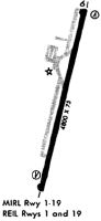
| Runways: | 01/19 |
| Longest Runway: | 01/19 is 4802 ft (1464 m) long |
| Runways with an Instrument Approach: |
KTGC Airport Runway Details
| Runway 01/19 | 4802 ft x 75 ft (1464 m x 23 m) | |
| Runway Length Source: | 3RD PARTY SURVEY as of 07/15/2011 | |
| Surface: | Asphalt - Good condition - No special surface treatment | |
| Runway Edge Lights: | Medium Intensity | |
Runway Weight Bearing Capacity (in thousands of pounds) |
||
| Single Wheel Landing Gear: | 30.0 | |
Runway 01 |
Runway 19 |
|
Elevation: |
358.0 | 355.1 |
Latitude: |
35-55-33.3733N | 35-56-20.2897N |
Longitude: |
088-51-00.6946W | 088-50-51.6873W |
|
Runway True Alignment: |
009 | 189 |
Glide Path Angle: |
3.0 degrees | 3.0 degrees |
Traffic Pattern: |
Left | Left |
Runway Markings Type: |
Nonprecision Instrument | Nonprecision Instrument |
Runway Markings Condition: |
Good | Good |
Object at End: |
TREE | TREE |
Object Height: |
17 | 102 |
Distance from End: |
284 | 1379 |
Object Centerline Offset: |
37 ft. right of centerline | 256 ft. left of centerline |
Visual Glide Slope Indicators: |
2-Light PAPI On Left Side Of Runway | 2-Light PAPI On Left Side Of Runway |
REIL: |
Yes | Yes |
Threshold Crossing Height: |
31 | 26 |
Services
Airframe Repair: |
Major |
Powerplant Repair: |
Major |
Bottled Oxygen: |
None |
Bulk Oxygen: |
None |
Fuel Available: |
100LL |
Landing Fees: |
No |
Parking: |
Tiedowns available |
Maps & Diagrams
KTGC Sectional
Flight Planning
at skyvector.com
at skyvector.com