Location
Latitude: |
33-45-45.1000N (33.762528) |
Longitude: |
090-45-28.6000W (-90.757944) |
Elevation: |
140.0 feet MSL (43 m MSL) |
Magnetic Variation: |
1.2 W (as of April 2024 from WMM2020 model) |
Time Zone: |
UTC -6.0 (Standard Time) UTC -5.0 (Daylight Savings Time) |
From City: |
02 N.M. NW of Cleveland, Mississippi |
Found On: |
Memphis Chart |
FAA Region: |
ASO |
Contacts
Manager: |
Publicly owned: |
| CLINT JOHNSON PO BOX 1439 CLEVELAND, MS 38732 662-719-1189 |
CITY OF CLEVELAND 100 NORTH ST CLEVELAND, MS 38732 662-843-5365 |
Operations
Airport Status: |
Operational |
Facility Use: |
Public |
Type: |
Airport |
Activation Date: |
04/1942 |
Control tower: |
No |
Attendance (Months/Days/Hours): |
Months/Days/Hours ALL/MON-FRI/0800-1700 |
Boundary ARTCC: |
ZME (Memphis) |
Responsible ARTCC: |
ZME (Memphis) |
Lighting Schedule: |
SEE RMK |
Segmented Circle Indicator: |
Yes |
Traffic Pattern Altitude (MSL): |
1140 feet (347 m) |
NOTAMs Facility: |
GWO |
NOTAM-D Service: |
Yes |
International Airport of Entry: |
No |
Customs Landing Rights: |
No |
Military Landing Rights: |
Yes |
Civil/Military Joint Use: |
No |
Based Aircraft
| Single Engine: | 59 |
| Multi Engine: | 6 |
| Jet Engine: | 1 |
Annual Operations (as of 12/13/2023)
| Total Operations: | 56389 | |
| GA Local: | 46892 | 83.2% |
| GA Itinerant: | 9497 | 16.8% |
Communications
| CTAF: | 122.725 |
| Unicom: | 122.725 |
| AWOS-3PT: | 124.175 (662-843-3021) |
- APCH/DEP SVC PRVDD BY MEMPHIS ARTCC ON FREQS 135.875/269.35 (GREENVILLE RCAG & PINE BLUFF RCAG).
Fixed Based Operators (FBOs) & Fuel
(Click on a business for detail)
Please help us keep this information up to date. This is a FREE SERVICE just like everything else on Airport Guide! If you see that a business needs to be added, modified, or deleted please fill out our Update Form.
To add, modify, or delete a business click here.
Please help us keep this information up to date. This is a FREE SERVICE just like everything else on Airport Guide! If you see that a business needs to be added, modified, or deleted please fill out our Update Form.
Area Code: 662 |
| Business Name | Frequency | Phone | Fuel Grade |
|---|
Flight Service Stations
| Primary | Alternate | |
| FSS on Field: | N | |
| FSS Name (ID): | Greenwood(GWO) | |
| Frequency: | ||
| Toll Free Phone: | 1-800-WX-BRIEF |
Instrument Procedures / Charts
FAA Terminal Procedures valid from 0901Z 03/21/24 to 0901Z 04/18/24.
There are various types of charts available for an airport. They are listed in the Page Type column. Here is a legend for those types:
APD - Airport Diagram
DP - Departure Procedure Charts
HOT - Hot Spots
IAP - Instrument Approach Procedure Charts
MIN - Minimums
STAR - Standard Terminal Arrival Charts
| Page Type | Page Name | Volume | Action Since Last Cycle |
|---|---|---|---|
| IAP | RNAV (GPS) RWY 18 | SC-4 | |
| IAP | RNAV (GPS) RWY 36 | SC-4 | |
| IAP | VOR-A | SC-4 | |
| MIN | ALTERNATE MINIMUMS | SC-4 | |
| MIN | TAKEOFF MINIMUMS | SC-4 |
Terminal Procedures are only available for airports in several countries with more being added all the time. If you are looking for a specific country's charts, please send an email to support(at)airportguide.com stating the country name. This will be used to prioritize the implementation.
Navigation Aids (Navaids) near KRNV
| Dist (NM) | ID | Morse Code | Name | Type | Freq | True Hdg | Mag Hdg |
|---|---|---|---|---|---|---|---|
| 18.2 | GLH | _ _ . . _ . . . . . . | Greenville | VOR-DME | 114.25 | 218 | 219 |
| 23.1 | MTQ | _ _ _ _ _ . _ | Metcalf | NDB | 359 | 209 | 210 |
| 30.0 | SQS | . . . _ _ . _ . . . | Sidon | VORTAC | 114.70 | 126 | 127 |
| 35.2 | GW | _ _ . . _ _ | Teock | NDB | 349 | 106 | 107 |
| 44.7 | SBQ | . . . _ . . . _ _ . _ | Scobey | NDB | 245 | 79 | 81 |
| 48.9 | UJM | . . _ . _ _ _ _ _ | Marvell | VOR-DME | 109.60 | 4 | 5 |
| 49.3 | MON | _ _ _ _ _ _ . | Monticello | DME | 111.6 | 256 | 257 |
| 60.0 | BLE | _ . . . . _ . . . | Lake Providence | NDB | 278 | 201 | 202 |
| 60.5 | TT | _ _ | Stutt | NDB | 338 | 317 | 318 |
| 65.0 | PBF | . _ _ . _ . . . . . _ . | Pine Bluff | VOR-DME | 116.00 | 296 | 297 |
| 67.5 | UV | . . _ . . . _ | Tunng | NDB | 426 | 56 | 58 |
| 68.0 | SGT | . . . _ _ . _ | Stuttgart | NDB | 269 | 322 | 323 |
| 80.9 | JAN | . _ _ _ . _ _ . | Jackson | VORTAC | 112.60 | 158 | 159 |
| 82.7 | BQP | _ . . . _ _ . _ . _ _ . | Bastrop | NDB | 329 | 223 | 224 |
| 84.4 | MEM | _ _ . _ _ | Memphis | VORTAC | 117.50 | 26 | 28 |
| 84.7 | JH | . _ _ _ . . . . | Brenz | NDB | 260 | 162 | 163 |
| 85.0 | ME | _ _ . | Elvis | NDB | 287 | 23 | 25 |
| 86.3 | MEM | _ _ . _ _ | Memphis Metropolitn | VOT | 111.00 | 26 | 28 |
| 86.3 | MHZ | _ _ . . . . _ _ . . | Magnolia | VORTAC | 113.20 | 157 | 158 |
| 87.0 | HLI | . . . . . _ . . . . | Holly Springs | VORTAC | 112.40 | 45 | 47 |
Nearby Airports with Fuel
Notices to Airmen (NOTAMS)
Remarks
| A110-2 | STUDENT ACT ON & INVOF ARPT. |
| A110-3 | FOR CD CTC MEMPHIS ARTCC AT 901-368-8453/8449. |
| A110-4 | COURTESY CAR AVBL. |
| A70-FUEL-10 | 0LL FUEL AVBL WITH CREDIT CARD 24 HRS. |
| A75 | PILOTS MUST PRVD THEIR OWN TIEDOWN ROPES. |
| A81-APT | ACTVT REIL RWY 18 & 36; MIRL RWY 18/36 - CTAF. PAPI RWY 18 & 36 OPR CONSLY. |
| E111 | EXISTED PRIOR TO 1959. |
Runways
Runway Summary
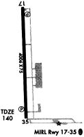
| Runways: | 18/36 |
| Longest Runway: | 18/36 is 5005 ft (1526 m) long |
| Runways with an Instrument Approach: |
KRNV Airport Runway Details
| Runway 18/36 | 5005 ft x 75 ft (1526 m x 23 m) | |
| Runway Length Source: | 3RD PARTY SURVEY as of 06/21/2013 | |
| Surface: | Asphalt - Good condition - No special surface treatment | |
| Runway Edge Lights: | Medium Intensity | |
Runway Weight Bearing Capacity (in thousands of pounds) |
||
| Single Wheel Landing Gear: | 26.0 | |
Runway 18 |
Runway 36 |
|
Elevation: |
139.5 | 140.0 |
Latitude: |
33-46-09.8158N | 33-45-20.3340N |
Longitude: |
090-45-29.6967W | 090-45-27.4656W |
|
Runway True Alignment: |
178 | 358 |
Glide Path Angle: |
3.0 degrees | 3.2 degrees |
Traffic Pattern: |
Left | Left |
Runway Markings Type: |
Nonprecision Instrument | Nonprecision Instrument |
Runway Markings Condition: |
Good | Good |
Object at End: |
TREES | |
Object Height: |
40 | |
Object Marked/Lighted?: |
Marked | |
Distance from End: |
1000 | |
Object Centerline Offset: |
0 ft. left and right of centerline | |
Visual Glide Slope Indicators: |
4-Light PAPI On Left Side Of Runway | 4-Light PAPI On Right Side Of Runway |
REIL: |
Yes | Yes |
Threshold Crossing Height: |
42 | 46 |
Services
Airframe Repair: |
Major |
Powerplant Repair: |
Major |
Fuel Available: |
100LL |
Landing Fees: |
No |
Parking: |
Hangars and tiedowns available |
Other Services: |
Parachute rental |
Maps & Diagrams
KRNV Sectional
Flight Planning
at skyvector.com
at skyvector.com