Location
Latitude: |
36-05-21.4705N (36.089297) |
Longitude: |
088-27-47.8756W (-88.463299) |
Elevation: |
496.6 feet MSL (151 m MSL) |
Magnetic Variation: |
3 W (as of April 2024 from WMM2020 model) |
Time Zone: |
UTC -6.0 (Standard Time) UTC -5.0 (Daylight Savings Time) |
From City: |
04 N.M. NW of Huntingdon, Tennessee |
Found On: |
Memphis Chart |
FAA Region: |
ASO |
Contacts
Manager: |
Publicly owned: |
| TOMMY SWOR 535 AIRPORT LANE MCKENZIE, TN 38201 731-352-7278 |
CARROLL COUNTY 625 HIGH STREET, SUITE 101 HUNTINGDON, TN 38344 731-986-1936 |
Operations
Airport Status: |
Operational |
Facility Use: |
Public |
Type: |
Airport |
Activation Date: |
06/1987 |
Control tower: |
No |
Attendance (Months/Days/Hours): |
Months/Days/Hours ALL/MON-SAT/0800-1700 |
Boundary ARTCC: |
ZME (Memphis) |
Responsible ARTCC: |
ZME (Memphis) |
Lighting Schedule: |
SEE RMK |
Segmented Circle Indicator: |
Yes |
Traffic Pattern Altitude (MSL): |
1497 feet (456 m) |
NOTAMs Facility: |
MKL |
NOTAM-D Service: |
Yes |
Based Aircraft
| Single Engine: | 19 |
| Jet Engine: | 2 |
Annual Operations (as of 05/31/2019)
| Total Operations: | 14250 | |
| Air Taxi: | 50 | 0.4% |
| GA Local: | 10650 | 74.7% |
| GA Itinerant: | 3500 | 24.6% |
| Military Aircraft: | 50 | 0.4% |
Communications
| CTAF: | 122.800 |
| Unicom: | 122.800 |
| AWOS-3: | 133.275 (731-352-2854) |
- APCH/DEP SVC PRVDD BY MEMPHIS ARTCC ON FREQS 134.65/316.15 (MCKELLAR RCAG).
Fixed Based Operators (FBOs) & Fuel
(Click on a business for detail)
Please help us keep this information up to date. This is a FREE SERVICE just like everything else on Airport Guide! If you see that a business needs to be added, modified, or deleted please fill out our Update Form.
To add, modify, or delete a business click here.
Please help us keep this information up to date. This is a FREE SERVICE just like everything else on Airport Guide! If you see that a business needs to be added, modified, or deleted please fill out our Update Form.
Area Code: 731 |
| Business Name | Frequency | Phone | Fuel Grade |
|---|---|---|---|
| Swor Aviation
Update FBO info |
Unicom 122.8 | 352-7278 | 100LL, Jet A |
Flight Service Stations
| Primary | Alternate | |
| FSS on Field: | ||
| FSS Name (ID): | Jackson(MKL) | |
| Frequency: | ||
| Toll Free Phone: | 1-800-WX-BRIEF |
Instrument Procedures / Charts
FAA Terminal Procedures valid from 0901Z 03/21/24 to 0901Z 04/18/24.
There are various types of charts available for an airport. They are listed in the Page Type column. Here is a legend for those types:
APD - Airport Diagram
DP - Departure Procedure Charts
HOT - Hot Spots
IAP - Instrument Approach Procedure Charts
MIN - Minimums
STAR - Standard Terminal Arrival Charts
| Page Type | Page Name | Volume | Action Since Last Cycle |
|---|---|---|---|
| IAP | RNAV (GPS) RWY 01 | SE-1 | |
| IAP | RNAV (GPS) RWY 19 | SE-1 | |
| MIN | TAKEOFF MINIMUMS | SE-1 |
Terminal Procedures are only available for airports in several countries with more being added all the time. If you are looking for a specific country's charts, please send an email to support(at)airportguide.com stating the country name. This will be used to prioritize the implementation.
Navigation Aids (Navaids) near KHZD
| Dist (NM) | ID | Morse Code | Name | Type | Freq | True Hdg | Mag Hdg |
|---|---|---|---|---|---|---|---|
| 0.2 | HZD | . . . . _ _ . . _ . . | Huntingdon | NDB | 217 | 254 | 257 |
| 9.9 | TIQ | _ . . _ _ . _ | Trainer | NDB | 410 | 13 | 16 |
| 28.6 | UC | . . _ _ . _ . | Obion | NDB | 212 | 296 | 299 |
| 29.9 | JKS | . _ _ _ _ . _ . . . | Jacks Creek | VOR-DME | 109.40 | 170 | 173 |
| 35.0 | AEY | . _ . _ . _ _ | Waverly | NDB | 329 | 87 | 90 |
| 36.4 | MKL | _ _ _ . _ . _ . . | Mc Kellar | VOR-DME | 112.00 | 216 | 219 |
| 38.8 | EU | . . . _ | Murey | NDB | 368 | 12 | 15 |
| 41.7 | DYR | _ . . _ . _ _ . _ . | Dyersburg | TACAN | 116.80 | 264 | 267 |
| 42.0 | MKL | _ _ _ . _ . _ . . | Mersy | NDB | 394 | 215 | 218 |
| 50.0 | DMZ | _ . . _ _ _ _ . . | Dickson | NDB | 203 | 87 | 90 |
| 51.2 | SZY | . . . _ _ . . _ . _ _ | Sibley | NDB | 386 | 182 | 185 |
| 51.5 | GHM | _ _ . . . . . _ _ | Graham | DME | 111.6 | 107 | 110 |
| 55.3 | JHG | . _ _ _ . . . . _ _ . | Hohenwald | NDB | 257 | 132 | 135 |
| 57.3 | HXW | . . . . _ . . _ . _ _ | Screaming Eagle | TACAN | 114.90 | 53 | 56 |
| 58.0 | CNG | _ . _ . _ . _ _ . | Cunningham | VOR-DME | 113.10 | 342 | 345 |
| 58.3 | CK | _ . _ . _ . _ | Snuff | NDB | 335 | 62 | 65 |
| 60.0 | CKV | _ . _ . _ . _ . . . _ | Clarksville | VOR-DME | 110.60 | 57 | 60 |
| 62.3 | COO | _ . _ . _ _ _ _ _ _ | Covington | NDB | 326 | 241 | 244 |
| 62.6 | CHQ | _ . _ . . . . . _ _ . _ | Charleston | NDB | 208 | 316 | 319 |
| 63.9 | FK | . . _ . _ . _ | Airbe | NDB | 273 | 52 | 55 |
Nearby Airports with Fuel
Notices to Airmen (NOTAMS)
Remarks
| A110-1 | FOR CD CTC MEMPHIS ARTCC AT 901-368-8453/8449. |
| A17 | AFT HR - 731-641-0123. |
| A43-01 | PAPI UNUSBL BYD 9 DEGS RIGHT OF CNTRLN. |
| A43-19 | PAPI UNUSBL BYD 9 DEGS LEFT AND 8 DEGS RIGHT OF CNTRLN. |
| A81-APT | ACTVT REIL RWY 01 & 19; PAPI RWY 01 & 19; MIRL RWY 01/19 - CTAF. MIRL RWY 01/19 PRESET MED INTST; INCR INTST - CTAF. |
| E111 | PRVDD VFR ONLY. |
Runways
Runway Summary
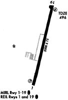
| Runways: | 01/19 |
| Longest Runway: | 01/19 is 5507 ft (1679 m) long |
| Runways with an Instrument Approach: |
KHZD Airport Runway Details
| Runway 01/19 | 5507 ft x 100 ft (1679 m x 30 m) | |
| Runway Length Source: | 3RD PARTY SURVEY as of 04/14/2008 | |
| Surface: | Asphalt - Good condition - No special surface treatment | |
| Runway Pavement Class: | 6 /F/D/X/T | |
| Runway Edge Lights: | Medium Intensity | |
Runway Weight Bearing Capacity (in thousands of pounds) |
||
| Single Wheel Landing Gear: | 48.0 | |
| Dual Wheel Landing Gear: | 66.0 | |
Runway 01 |
Runway 19 |
|
Elevation: |
495.3 | 496.6 |
Latitude: |
36-04-54.8574N | 36-05-48.0836N |
Longitude: |
088-27-54.9776W | 088-27-40.7735W |
|
Runway True Alignment: |
012 | 192 |
Glide Path Angle: |
3.0 degrees | 4.0 degrees |
Runway Markings Type: |
Nonprecision Instrument | Nonprecision Instrument |
Runway Markings Condition: |
Good | Fair |
Object at End: |
TREE | TREE |
Object Height: |
73 | 74 |
Distance from End: |
2166 | 1317 |
Object Centerline Offset: |
468 ft. right of centerline | 322 ft. left of centerline |
Visual Glide Slope Indicators: |
4-Light PAPI On Left Side Of Runway | 4-Light PAPI On Left Side Of Runway |
REIL: |
Yes | Yes |
Threshold Crossing Height: |
26 | 28 |
Services
Airframe Repair: |
Minor |
Powerplant Repair: |
Minor |
Fuel Available: |
100LL, Jet A+ |
Landing Fees: |
No |
Parking: |
Hangars and tiedowns available |
Maps & Diagrams
KHZD Sectional
Flight Planning
at skyvector.com
at skyvector.com