Location
Latitude: |
39-43-30.6000N (39.725167) |
Longitude: |
091-26-37.9000W (-91.443861) |
Elevation: |
768.9 feet MSL (234 m MSL) |
Magnetic Variation: |
1.1 W (as of April 2024 from WMM2020 model) |
Time Zone: |
UTC -6.0 (Standard Time) UTC -5.0 (Daylight Savings Time) |
From City: |
04 N.M. NW of Hannibal, Missouri |
Found On: |
Kansas City Chart |
FAA Region: |
ACE |
Contacts
Manager: |
Publicly owned: |
| ANDY DORIAN CITY OF HANNIBAL, 6079 COUNTY ROAD 425 HANNIBAL, MO 63401 573-406-3728 |
CITY OF HANNIBAL 320 BROADWAY HANNIBAL, MO 63401 573-221-0111 |
Operations
Airport Status: |
Operational |
Facility Use: |
Public |
Type: |
Airport |
Activation Date: |
04/1940 |
Control tower: |
No |
Attendance (Months/Days/Hours): |
Months/Days/Hours ALL/ALL/0800-DUSK |
Boundary ARTCC: |
ZKC (Kansas City) |
Responsible ARTCC: |
ZKC (Kansas City) |
Lighting Schedule: |
SEE RMK |
Segmented Circle Indicator: |
Yes |
Traffic Pattern Altitude (MSL): |
1769 feet (539 m) |
NOTAMs Facility: |
STL |
NOTAM-D Service: |
Yes |
International Airport of Entry: |
No |
Customs Landing Rights: |
No |
Military Landing Rights: |
Yes |
Civil/Military Joint Use: |
No |
Based Aircraft
| Single Engine: | 13 |
| Multi Engine: | 1 |
| Jet Engine: | 1 |
| GA Helicopters: | 1 |
Annual Operations (as of 12/31/2021)
| Total Operations: | 9661 | |
| Air Taxi: | 320 | 3.3% |
| GA Local: | 3458 | 35.8% |
| GA Itinerant: | 5823 | 60.3% |
| Military Aircraft: | 60 | 0.6% |
Communications
| CTAF: | 122.800 |
| Unicom: | 122.800 |
| AWOS-3PT: | 120.775 (573-221-2584) |
- APCH/DEP SVC PRVDD BY KANSAS CITY ARTCC ON FREQS 126.225/317.775 (QUINCY RCAG).
Fixed Based Operators (FBOs) & Fuel
(Click on a business for detail)
Please help us keep this information up to date. This is a FREE SERVICE just like everything else on Airport Guide! If you see that a business needs to be added, modified, or deleted please fill out our Update Form.
To add, modify, or delete a business click here.
Please help us keep this information up to date. This is a FREE SERVICE just like everything else on Airport Guide! If you see that a business needs to be added, modified, or deleted please fill out our Update Form.
Area Code: 573 |
| Business Name | Frequency | Phone | Fuel Grade |
|---|---|---|---|
| Mid America Aviation
Update FBO info |
Unicom 122.8 | 221-3230 | 100LL |
Flight Service Stations
| Primary | Alternate | |
| FSS on Field: | N | |
| FSS Name (ID): | Saint Louis(STL) | |
| Frequency: | ||
| Toll Free Phone: | 1-800-WX-BRIEF |
Instrument Procedures / Charts
FAA Terminal Procedures valid from 0901Z 03/21/24 to 0901Z 04/18/24.
There are various types of charts available for an airport. They are listed in the Page Type column. Here is a legend for those types:
APD - Airport Diagram
DP - Departure Procedure Charts
HOT - Hot Spots
IAP - Instrument Approach Procedure Charts
MIN - Minimums
STAR - Standard Terminal Arrival Charts
| Page Type | Page Name | Volume | Action Since Last Cycle |
|---|---|---|---|
| IAP | RNAV (GPS) RWY 17 | NC-3 | |
| IAP | RNAV (GPS) RWY 35 | NC-3 | |
| MIN | TAKEOFF MINIMUMS | NC-3 |
Terminal Procedures are only available for airports in several countries with more being added all the time. If you are looking for a specific country's charts, please send an email to support(at)airportguide.com stating the country name. This will be used to prioritize the implementation.
Navigation Aids (Navaids) near KHAE
| Dist (NM) | ID | Morse Code | Name | Type | Freq | True Hdg | Mag Hdg |
|---|---|---|---|---|---|---|---|
| 10.6 | UIN | . . _ . . _ . | Quincy | TACAN | 113.60 | 45 | 46 |
| 13.1 | UI | . . _ . . | Quincy | NDB | 293 | 42 | 43 |
| 44.4 | EOK | . _ _ _ _ . _ | Keokuk | NDB | 366 | 0 | 1 |
| 48.1 | MCM | _ _ _ . _ . _ _ | Macon | DME | 112.9 | 265 | 266 |
| 48.5 | HLV | . . . . . _ . . . . . _ | Hallsville | VORTAC | 114.20 | 221 | 222 |
| 55.7 | IJX | . . . _ _ _ _ . . _ | Jacksonville | DME | 108.6 | 86 | 88 |
| 57.7 | BR | _ . . . . _ . | Burns | NDB | 390 | 14 | 15 |
| 58.3 | IRK | . . . _ . _ . _ | Kirksville | VORTAC | 114.60 | 295 | 296 |
| 62.5 | JZY | . _ _ _ _ _ . . _ . _ _ | Macomb | NDB | 251 | 40 | 41 |
| 64.4 | BRL | _ . . . . _ . . _ . . | Burlington | VOR-DME | 111.40 | 21 | 22 |
| 65.6 | COU | _ . _ . _ _ _ . . _ | Columbia | VOR-DME | 110.20 | 213 | 214 |
| 65.6 | FTZ | . . _ . _ _ _ . . | Foristell | VORTAC | 110.80 | 160 | 161 |
| 68.4 | STL | . . . _ . _ . . | St Louis | VORTAC | 117.40 | 138 | 139 |
| 71.5 | LM | . _ . . _ _ | Oblio | NDB | 338 | 140 | 141 |
| 72.4 | SU | . . . . . _ | Snoop | NDB | 326 | 154 | 155 |
| 73.5 | MPZ | _ _ . _ _ . _ _ . . | Mount Pleasant | NDB | 212 | 357 | 358 |
| 73.6 | SUS | . . . . . _ . . . | Spirit Of St Louis | VOT | 112.20 | 149 | 150 |
| 75.4 | FZ | . . _ . _ _ . . | Eaves | NDB | 227 | 146 | 147 |
| 75.6 | JEF | . _ _ _ . . . _ . | Jefferson City | VOT | 112.00 | 206 | 207 |
| 76.1 | BEX | _ . . . . _ . . _ | Bloomfield | NDB | 269 | 323 | 324 |
Nearby Airports with Fuel
Notices to Airmen (NOTAMS)
Remarks
| A110-2 | MAINTAIN CLEAR OF HOSPITAL AREA WHEN DEPARTING RWY 17. |
| A110-3 | GLIDER ACTIVITY ON ARPT. |
| A110-4 | DEER INVOF MOVEMENT AREAS. |
| A110-5 | FOR CD CTC KANSAS CITY ARTCC AT 913-254-8508. |
| A81-APT | ACTVT REIL RWY 17 AND 35; MIRL RWY 17/35 - CTAF. PAPI RWY 17 AND 35 OPR CONSLY. |
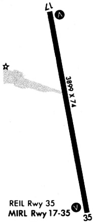
Runways
Runway Summary
| Runways: | 17/35 |
| Longest Runway: | 17/35 is 4400 ft (1341 m) long |
| Runways with an Instrument Approach: |
KHAE Airport Runway Details
| Runway 17/35 | 4400 ft x 100 ft (1341 m x 30 m) | |
| Runway Length Source: | FAA as of 12/10/2002 | |
| Surface: | Concrete - Good condition - No special surface treatment | |
| Runway Pavement Class: | 7 /R/B/W/U | |
| Runway Edge Lights: | Medium Intensity | |
Runway Weight Bearing Capacity (in thousands of pounds) |
||
| Single Wheel Landing Gear: | 12.0 | |
Runway 17 |
Runway 35 |
|
Elevation: |
758.0 | 767.8 |
Latitude: |
39-43-51.9845N | 39-43-09.1904N |
Longitude: |
091-26-42.8607W | 091-26-32.8664W |
|
Runway True Alignment: |
170 | 350 |
Glide Path Angle: |
3.0 degrees | 3.0 degrees |
Traffic Pattern: |
Left | Right |
Runway Markings Type: |
Nonprecision Instrument | Nonprecision Instrument |
Runway Markings Condition: |
Good | Good |
Object at End: |
TREES | |
Object Height: |
55 | |
Distance from End: |
1285 | |
Object Centerline Offset: |
415 ft. left and right of centerline | |
Visual Glide Slope Indicators: |
4-Light PAPI On Left Side Of Runway | 4-Light PAPI On Left Side Of Runway |
REIL: |
Yes | Yes |
Threshold Crossing Height: |
44 | 40 |
Services
Airframe Repair: |
Major |
Powerplant Repair: |
Major |
Fuel Available: |
100LL, Jet A+ |
Landing Fees: |
No |
Parking: |
Tiedowns available |
Maps & Diagrams
KHAE Sectional
Flight Planning
at skyvector.com
at skyvector.com