Location
Latitude: |
43-36-26.4000N (43.607333) |
Longitude: |
110-44-15.9000W (-110.73775) |
Elevation: |
6450.7 feet MSL (1966 m MSL) |
Magnetic Variation: |
10.9 E (as of April 2024 from WMM2020 model) |
Time Zone: |
UTC -7.0 (Standard Time) UTC -6.0 (Daylight Savings Time) |
From City: |
07 N.M. N of Jackson, Wyoming |
Found On: |
Salt Lake City Chart |
FAA Region: |
ANM |
Contacts
Manager: |
Publicly owned: |
| JIM ELWOOD P. O. BOX 159 JACKSON, WY 83001 (307) 733-7695 |
JACKSON HOLE AIRPORT BOARD P. O. BOX 159 JACKSON, WY 83001 307-733-7682 |
Operations
Airport Status: |
Operational |
Facility Use: |
Public |
Type: |
Airport |
Activation Date: |
10/1941 |
Control tower: |
Yes |
Attendance (Months/Days/Hours): |
Months/Days/Hours ALL/ALL/0700-2130 |
Boundary ARTCC: |
ZLC (Salt Lake City) |
Responsible ARTCC: |
ZLC (Salt Lake City) |
Lighting Schedule: |
SEE RMK |
Segmented Circle Indicator: |
No |
Traffic Pattern Altitude (MSL): |
7451 feet (2271 m) |
NOTAMs Facility: |
JAC |
NOTAM-D Service: |
Yes |
International Airport of Entry: |
No |
Customs Landing Rights: |
No |
Military Landing Rights: |
Yes |
Civil/Military Joint Use: |
No |
Aircraft Rescue and Firefighting: |
Class I ARFF Index: B Air Carrier Service: Scheduled Certification Date: 05/1973 |
Based Aircraft
| Single Engine: | 13 |
| Multi Engine: | 2 |
| Jet Engine: | 5 |
Annual Operations (as of 12/31/2022)
| Total Operations: | 28848 | |
| Commercial: | 9103 | 31.6% |
| Air Taxi: | 9894 | 34.3% |
| GA Local: | 114 | 0.4% |
| GA Itinerant: | 9564 | 33.2% |
| Military Aircraft: | 173 | 0.6% |
Communications
| CTAF: | 118.075 |
| Unicom: | 122.950 |
| Tower: | JACKSON 118.075 Hrs: 0700-2100 |
| Ground: | 124.55 |
| Approach: | SALT LAKE ARTCC |
| Departure: | SALT LAKE ARTCC |
| ATIS: | 120.625 Hrs: 24 |
| AWOS-3PT: | (307-739-9108) |
- APCH/DEP CTL SVC PRVDD BY SALT LAKE ARTCC (ZLC) ON FREQS 133.25/285.6 (JACKSON RCAG).
- ATCT OPERATED BY CERCO.
Fixed Based Operators (FBOs) & Fuel
(Click on a business for detail)
Please help us keep this information up to date. This is a FREE SERVICE just like everything else on Airport Guide! If you see that a business needs to be added, modified, or deleted please fill out our Update Form.
To add, modify, or delete a business click here.
Please help us keep this information up to date. This is a FREE SERVICE just like everything else on Airport Guide! If you see that a business needs to be added, modified, or deleted please fill out our Update Form.
Area Code: 307 |
| Business Name | Frequency | Phone | Fuel Grade |
|---|---|---|---|
| Jackson Hole Aviation
Update FBO info |
Unicom 122.8 | 733-4767 | 100LL, Jet A |
Flight Service Stations
| Primary | Alternate | |
| FSS on Field: | N | |
| FSS Name (ID): | Casper(CPR) | |
| Frequency: | ||
| Toll Free Phone: | 1-800-WX-BRIEF |
Instrument Procedures / Charts
FAA Terminal Procedures valid from 0901Z 03/21/24 to 0901Z 04/18/24.
There are various types of charts available for an airport. They are listed in the Page Type column. Here is a legend for those types:
APD - Airport Diagram
DP - Departure Procedure Charts
HOT - Hot Spots
IAP - Instrument Approach Procedure Charts
MIN - Minimums
STAR - Standard Terminal Arrival Charts
| Page Type | Page Name | Volume | Action Since Last Cycle |
|---|---|---|---|
| APD | AIRPORT DIAGRAM | NW-1 | |
| DP | ALPIN FOUR | NW-1 | |
| DP | DIVYD TWO (RNAV) | NW-1 | |
| HOT | HOT SPOT | NW-1 | |
| IAP | ILS Y OR LOC Y RWY 19 | NW-1 | |
| IAP | ILS Z OR LOC Z RWY 19 | NW-1 | |
| IAP | RNAV (GPS) X RWY 01 | NW-1 | |
| IAP | RNAV (GPS) Z RWY 19 | NW-1 | |
| IAP | RNAV (RNP) X RWY 19 | NW-1 | |
| IAP | RNAV (RNP) Y RWY 01 | NW-1 | |
| IAP | RNAV (RNP) Y RWY 19 | NW-1 | |
| IAP | RNAV (RNP) Z RWY 01 | NW-1 | |
| IAP | VOR RWY 01 | NW-1 | |
| IAP | VOR RWY 19 | NW-1 | |
| MIN | ALTERNATE MINIMUMS | NW-1 | |
| MIN | TAKEOFF MINIMUMS | NW-1 | |
| ODP | GEYSER SIX (OBSTACLE) | NW-1 | |
| ODP | TETON THREE (OBSTACLE) | NW-1 |
Terminal Procedures are only available for airports in several countries with more being added all the time. If you are looking for a specific country's charts, please send an email to support(at)airportguide.com stating the country name. This will be used to prioritize the implementation.
Navigation Aids (Navaids) near JAC
| Dist (NM) | ID | Morse Code | Name | Type | Freq | True Hdg | Mag Hdg |
|---|---|---|---|---|---|---|---|
| 0.9 | JAC | . _ _ _ . _ _ . _ . | Jackson | VOR-DME | 115.40 | 17 | 6 |
| 21.9 | DNW | _ . . _ . . _ _ | Dunoir | VOR-DME | 117.20 | 52 | 41 |
| 54.0 | ID | . . _ . . | Uconn | NDB | 324 | 269 | 258 |
| 57.9 | IDA | . . _ . . . _ | Idaho Falls | VOR-DME | 113.85 | 265 | 254 |
| 61.4 | LO | . _ . . _ _ _ | Targy | NDB | 415 | 341 | 330 |
| 62.9 | SWU | . . . . _ _ . . _ | Sweden | NDB | 350 | 260 | 249 |
| 63.6 | PNA | . _ _ . _ . . _ | Wenz | NDB | 392 | 139 | 128 |
| 66.3 | WYS | . _ _ _ . _ _ . . . | West Yellowstone | DME | 114.85 | 345 | 334 |
| 67.0 | ESY | . . . . _ . _ _ | Yellowstone | NDB | 338 | 345 | 334 |
| 67.5 | BPI | _ . . . . _ _ . . . | Big Piney | VOR-DME | 116.50 | 155 | 144 |
| 69.9 | DBS | _ . . _ . . . . . . | Dubois | VORTAC | 116.90 | 294 | 283 |
| 86.7 | PI | . _ _ . . . | Tyhee | NDB | 383 | 244 | 233 |
| 94.6 | PIH | . _ _ . . . . . . . | Pocatello | VOR-DME | 112.60 | 242 | 231 |
| 97.6 | COD | _ . _ . _ _ _ _ . . | Cody | VOR-DME | 111.80 | 50 | 39 |
Nearby Airports with Fuel
Notices to Airmen (NOTAMS)
Remarks
| A11 | LEASED FROM U S PARK SERVICE. |
| A110*G | THIS AIRPORT HAS BEEN SURVEYED BY THE NATIONAL GEODETIC SURVEY. |
| A110-1 | 35'-53' TREES 700'-800' WEST OF THR RY 01. |
| A110-10 | PAVED 950X200 FT SAFETY AREA AT THE DEP END OF RWY 19; NOT USBL FOR PER CALCULATIONS; PLOWED & BROOMED DURG WINTER. |
| A110-11 | DEICING PAD LOCATED AT NORTH END OF TWY A. |
| A110-12 | COLD TEMPERATURE AIRPORT. ALTITUDE CORRECTION REQUIRED AT OR BELOW -22C. |
| A110-13 | FOR CD IF UNA TO CTC ON FSS FREQ, CTC JAC TWR GND AT 124.55 DURG NML OPRG HRS. OUTSIDE OF NML OPRG HRS, CTC SALT LAKE ARTCC AT 801-320-2568. |
| A110-14 | ACFT PUSHING BACK FM TRML CAUSE CGSTN, MAKING A2 UNAVBL. COORD RWY EXITS WITH TWR. |
| A110-2 | NOISE ABATEMENT PROCEDURES IN EFFECT FOR ACFT DEPARTURES ON RWY 19. |
| A110-3 | SAGE GROUSE ON & INVOF ARPT APR THRU OCT. |
| A110-5 | POSSIBLE SEVERE WINTER CONDITIONS FROM NOV-APR; NO ARPT INFO OR SNOW REMOVAL GUARANTEED DURING HOURS OF NON ATTENDANCE. 307-733-7682 |
| A110-6 | HANG GLIDING OPNS 9 MILES S OF ARPT NEAR SKI ARE & 9 MILES SSW OF ARPT ALONG THE RIDGE. |
| A110-7 | BALLOON OPERATIONS IN VICINITY OF AIRPORT, W AND SW, MAY-OCT. |
| A110-8 | FOR PUBLIC HEALTH & SAFETY FLIGHTS, CONTACT AMGR @ 307-733-7682. |
| A110-9 | ACFT THAT FAIL TO TOUCH DOWN WITHIN THE FIRST THIRD OF RY 01/19 SOMETIMES FAIL TO STOP ON THE RY AND ARE AT RISK FOR A RY EXCURSION. |
| A17 | ON CALL H24 PHONE 307-733-4767. |
| A39-01/19 | PCR VALUE: 508/F/C/X/T. |
| A81-APT | WHEN ATCT CLSD ACTVT MALS RWY 01 & 19; HIRL RWY 01/19; RCLS RWY 01/19; TWY LGTS; WDI - CTAF. |
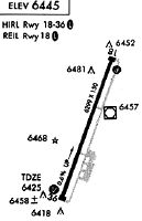
Runways
Runway Summary
| Runways: | 01/19 |
| Longest Runway: | 01/19 is 6300 ft (1920 m) long |
| Runways with an Instrument Approach: | 19 |
JAC Airport Runway Details
| Runway 01/19 | 6300 ft x 150 ft (1920 m x 46 m) | |
| Runway Length Source: | NGS as of 09/05/2002 | |
| Surface: | Asphalt - Excellent condition - Saw-cut or plastic grooved | |
| Runway Edge Lights: | High Intensity | |
Runway Weight Bearing Capacity (in thousands of pounds) |
||
| Single Wheel Landing Gear: | 120.0 | |
| Dual Wheel Landing Gear: | 187.0 | |
| Dual Tandem Wheel Landing Gear: | 287.0 | |
Runway 01 |
Runway 19 |
|
Elevation: |
6412.8 | 6450.5 |
Latitude: |
43-35-57.0985N | 43-36-55.7277N |
Longitude: |
110-44-30.1905W | 110-44-01.5978W |
|
Runway True Alignment: |
020 | 200 |
ILS Type: |
ILS/DME | |
Glide Path Angle: |
3.0 degrees | 3.0 degrees |
Traffic Pattern: |
Left | Left |
Runway Markings Type: |
Precision Instrument | Precision Instrument |
Runway Markings Condition: |
Good | Good |
Object at End: |
ROAD | |
Object Height: |
10 | |
Distance from End: |
249 | |
Object Centerline Offset: |
505 ft. left of centerline | |
Visual Glide Slope Indicators: |
4-Light PAPI On Left Side Of Runway | 4-Light PAPI On Right Side Of Runway |
Runway Visual Range (RVR): |
Touchdown, Midfield, Rollout | Touchdown, Midfield, Rollout |
Approach Light System: |
1,400 Foot Medium Intensity Approach Lighting System | 1,400 Foot Medium Intensity Approach Lighting System |
REIL: |
No | No |
Touchdown Lights: |
No | No |
Centerline Lights: |
Yes | Yes |
Threshold Crossing Height: |
50 | 53 |
Declared Distances |
||
Take Off Run Avbl. (TORA): |
6300 | 6300 |
Take Off Distance Avbl. (TODA): |
6300 | 6300 |
Actual Stop Dist. Avbl. (ASDA): |
6300 | 6300 |
Landing Dist. Avbl. (LDA): |
6300 | 6300 |
Services
Airframe Repair: |
Major |
Powerplant Repair: |
Major |
Bottled Oxygen: |
None |
Bulk Oxygen: |
None |
Fuel Available: |
100LL, Jet A |
Landing Fees: |
No |
Parking: |
Hangars and tiedowns available |
Maps & Diagrams
JAC Sectional
Flight Planning
at skyvector.com
at skyvector.com