Location
Latitude: |
39-46-28.6000N (39.774611) |
Longitude: |
090-14-17.8000W (-90.238278) |
Elevation: |
623.9 feet MSL (190 m MSL) |
Magnetic Variation: |
2 W (as of April 2024 from WMM2020 model) |
Time Zone: |
UTC -6.0 (Standard Time) UTC -5.0 (Daylight Savings Time) |
From City: |
03 N.M. N of Jacksonville, Illinois |
Found On: |
St Louis Chart |
FAA Region: |
AGL |
Contacts
Manager: |
Publicly owned: |
| SHASTIN SAXER 1956 BALDWIN RD, JACKSONVILLE AIRPORT JACKSONVILLE, IL 62650 217-243-5824 |
JACKSONVILLE AIRPORT AUTH 1956 BALDWIN RD JACKSONVILLE, IL 62650 217-243-5824 |
Operations
Airport Status: |
Operational |
Facility Use: |
Public |
Type: |
Airport |
Activation Date: |
07/1950 |
Control tower: |
No |
Attendance (Months/Days/Hours): |
Months/Days/Hours ALL/ALL/0700-DUSK |
Boundary ARTCC: |
ZKC (Kansas City) |
Responsible ARTCC: |
ZKC (Kansas City) |
Lighting Schedule: |
SEE RMK |
Segmented Circle Indicator: |
No |
Traffic Pattern Altitude (MSL): |
1624 feet (495 m) |
NOTAMs Facility: |
IJX |
NOTAM-D Service: |
Yes |
International Airport of Entry: |
No |
Customs Landing Rights: |
No |
Military Landing Rights: |
Yes |
Civil/Military Joint Use: |
No |
Based Aircraft
| Single Engine: | 31 |
| Multi Engine: | 2 |
| GA Helicopters: | 1 |
Annual Operations (as of 03/31/2023)
| Total Operations: | 12000 | |
| Air Taxi: | 1000 | 8.3% |
| GA Local: | 6000 | 50.0% |
| GA Itinerant: | 5000 | 41.7% |
Communications
| CTAF: | 122.800 |
| Unicom: | 122.800 |
| Clearance Del.: | 118.45 118.45 118.45 |
| Approach: | SAINT LOUIS KANSAS CITY ARTCC |
| Departure: | SAINT LOUIS KANSAS CITY ARTCC |
| AWOS-3PT: | 120.525 (217-243-6379) |
- APCH/DEP SVC PRVDD BY ST LOUIS TRACON (T75) ON FREQS 126.15/323.0 0600-2200. APCH/DEP SVC PRVDD BY KANSAS CITY ARTCC (ZKC) ON FREQS 127.275/307.1 (JACKSONVILLE RCAG) 2200-0600.
Fixed Based Operators (FBOs) & Fuel
(Click on a business for detail)
Please help us keep this information up to date. This is a FREE SERVICE just like everything else on Airport Guide! If you see that a business needs to be added, modified, or deleted please fill out our Update Form.
To add, modify, or delete a business click here.
Please help us keep this information up to date. This is a FREE SERVICE just like everything else on Airport Guide! If you see that a business needs to be added, modified, or deleted please fill out our Update Form.
Area Code: 217 |
| Business Name | Frequency | Phone | Fuel Grade |
|---|---|---|---|
| Jacksonville Airport Authority
Update FBO info |
243-5824 | 100LL, Jet A | |
| Klem's Aero Repair
Update FBO info |
245-2480 |
Flight Service Stations
| Primary | Alternate | |
| FSS on Field: | N | |
| FSS Name (ID): | Saint Louis(STL) | |
| Frequency: | ||
| Toll Free Phone: | 1-800-WX-BRIEF |
Instrument Procedures / Charts
FAA Terminal Procedures valid from 0901Z 03/21/24 to 0901Z 04/18/24.
There are various types of charts available for an airport. They are listed in the Page Type column. Here is a legend for those types:
APD - Airport Diagram
DP - Departure Procedure Charts
HOT - Hot Spots
IAP - Instrument Approach Procedure Charts
MIN - Minimums
STAR - Standard Terminal Arrival Charts
| Page Type | Page Name | Volume | Action Since Last Cycle |
|---|---|---|---|
| IAP | RNAV (GPS) RWY 04 | EC-3 | |
| IAP | RNAV (GPS) RWY 13 | EC-3 | |
| IAP | RNAV (GPS) RWY 22 | EC-3 | |
| IAP | RNAV (GPS) RWY 31 | EC-3 | |
| MIN | ALTERNATE MINIMUMS | EC-3 | |
| MIN | TAKEOFF MINIMUMS | EC-3 |
Terminal Procedures are only available for airports in several countries with more being added all the time. If you are looking for a specific country's charts, please send an email to support(at)airportguide.com stating the country name. This will be used to prioritize the implementation.
Navigation Aids (Navaids) near IJX
| Dist (NM) | ID | Morse Code | Name | Type | Freq | True Hdg | Mag Hdg |
|---|---|---|---|---|---|---|---|
| 0.1 | IJX | . . . _ _ _ _ . . _ | Jacksonville | DME | 108.6 | 352 | 354 |
| 22.1 | SP | . . . . _ _ . | Huskk | NDB | 382 | 90 | 92 |
| 26.1 | SPI | . . . . _ _ . . . | Spinner | VORTAC | 112.70 | 81 | 83 |
| 29.8 | CJ | _ . _ . . _ _ _ | Calde | NDB | 240 | 87 | 89 |
| 30.4 | LQ | . _ . . _ _ . _ | Licol | NDB | 375 | 74 | 76 |
| 44.6 | TAZ | _ . _ _ _ . . | Taylorville | NDB | 395 | 108 | 110 |
| 47.0 | JZY | . _ _ _ _ _ . . _ . _ _ | Macomb | NDB | 251 | 341 | 343 |
| 47.3 | UI | . . _ . . | Quincy | NDB | 293 | 278 | 280 |
| 47.4 | AAA | . _ . _ . _ | Abraham | NDB | 329 | 60 | 62 |
| 48.0 | CTK | _ . _ . _ _ . _ | Canton | NDB | 236 | 8 | 10 |
| 48.2 | UIN | . . _ . . _ . | Quincy | TACAN | 113.60 | 275 | 277 |
| 53.6 | CVM | _ . _ . . . . _ _ _ | Civic Memorial | NDB | 263 | 170 | 172 |
| 56.0 | STL | . . . _ . _ . . | St Louis | VORTAC | 117.40 | 191 | 193 |
| 56.9 | AL | . _ . _ . . | Alpos | NDB | 218 | 165 | 167 |
| 58.0 | PI | . _ _ . . . | Tungg | NDB | 356 | 30 | 32 |
| 58.0 | PIA | . _ _ . . . . _ | Peoria | VORTAC | 115.20 | 20 | 22 |
| 59.2 | ST | . . . _ | Zumay | NDB | 404 | 181 | 183 |
| 59.2 | DE | _ . . . | Elwin | NDB | 275 | 88 | 90 |
| 59.5 | LM | . _ . . _ _ | Oblio | NDB | 338 | 190 | 192 |
| 61.6 | CSX | _ . _ . . . . _ . . _ | Cardinal | DME | 116.45 | 185 | 187 |
Nearby Airports with Fuel
Notices to Airmen (NOTAMS)
Remarks
| A110-1 | DEER ON & INVOF OF ARPT. |
| A110-2 | FOR CD CTC ST LOUIS APCH 314-890-1017. |
| A15 | EMAIL ADDRESS: MANAGER@FLYIJX.COM. (ALL LOWER CASE) |
| A81-APT | ACTVT MIRL RY 13/31, 04/22, REIL RYS 22, 13 & 31, & TWY LGTS - CTAF. |
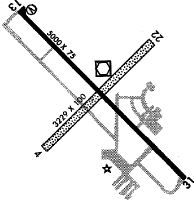
Runways
Runway Summary
| Runways: | 04/22 13/31 |
| Longest Runway: | 13/31 is 5000 ft (1524 m) long |
| Runways with an Instrument Approach: |
IJX Airport Runway Details
| Runway 04/22 | 4001 ft x 75 ft (1220 m x 23 m) | |
| Runway Length Source: | 3RD PARTY SURVEY as of 06/28/2012 | |
| Surface: | Asphalt - Good condition - No special surface treatment | |
| Runway Edge Lights: | Medium Intensity | |
Runway 04 |
Runway 22 |
|
Elevation: |
617.1 | 618.2 |
Latitude: |
39-46-15.2711N | 39-46-43.2309N |
Longitude: |
090-14-35.0868W | 090-13-58.8542W |
|
Runway True Alignment: |
045 | 225 |
Glide Path Angle: |
0.0 degrees | 0.0 degrees |
Traffic Pattern: |
Left | Left |
Runway Markings Type: |
Basic | Basic |
Runway Markings Condition: |
Fair | Fair |
REIL: |
No | Yes |
Touchdown Lights: |
No | No |
Centerline Lights: |
No | No |
| Runway 13/31 | 5000 ft x 75 ft (1524 m x 23 m) | |
| Runway Length Source: | 3RD PARTY SURVEY as of 06/28/2012 | |
| Surface: | Asphalt - Good condition - No special surface treatment | |
| Runway Edge Lights: | Medium Intensity | |
Runway Weight Bearing Capacity (in thousands of pounds) |
||
| Single Wheel Landing Gear: | 22.0 | |
| Dual Wheel Landing Gear: | 28.0 | |
Runway 13 |
Runway 31 |
|
Elevation: |
616.6 | 621.0 |
Latitude: |
39-46-45.5678N | 39-46-10.5403N |
Longitude: |
090-14-40.9962W | 090-13-55.8408W |
|
Runway True Alignment: |
135 | 315 |
Glide Path Angle: |
3.0 degrees | 0.0 degrees |
Traffic Pattern: |
Left | Left |
Runway Markings Type: |
Nonprecision Instrument | Nonprecision Instrument |
Runway Markings Condition: |
Fair | Fair |
Visual Glide Slope Indicators: |
4-Box VASI On Left Side Of Runway | |
REIL: |
Yes | Yes |
Touchdown Lights: |
No | No |
Centerline Lights: |
No | No |
Threshold Crossing Height: |
36 |
Services
Airframe Repair: |
Major |
Powerplant Repair: |
Major |
Bottled Oxygen: |
High Pressure / Low Pressure |
Bulk Oxygen: |
None |
Fuel Available: |
100LL, Jet A |
Landing Fees: |
No |
Parking: |
Hangars and tiedowns available |
Maps & Diagrams
IJX Sectional
Flight Planning
at skyvector.com
at skyvector.com