
Location
Latitude: |
22-59-21.1221N (22.989201) |
Longitude: |
082-24-32.7722W (-82.409103) |
Elevation: |
210 feet MSL (64 m MSL) |
Magnetic Variation: |
5.5 W (as of April 2024 from WMM2020 model) |
Time Zone: |
UTC -5.0 (Standard Time) UTC -4.0 (Daylight Savings Time) |
Contacts
Manager: |
: |
Operations
Airport Status: |
Operational |
Facility Use: |
Public |
Type: |
Airport |
Traffic Pattern Altitude (MSL): |
1210 feet (369 m) |
Based Aircraft
Annual Operations (as of )
Communications
| BOYEROS RDO NATL: | 126.9 |
| BOYEROS RDO INTL: | 288.7 |
| BOYEROS RDO NATL: | 1132.1 |
| BOYEROS RDO INTL: | 1329.7 |
| MARTI TWR: | 118.1 |
| CLNC DEL: | 121.9 |
| GND: | 121.9 |
| HABANA APP: | 119.35 |
| ATIS: | 132.5 |
Fixed Based Operators (FBOs) & Fuel
(Click on a business for detail)
Please help us keep this information up to date. This is a FREE SERVICE just like everything else on Airport Guide! If you see that a business needs to be added, modified, or deleted please fill out our Update Form.
To add, modify, or delete a business click here.
Please help us keep this information up to date. This is a FREE SERVICE just like everything else on Airport Guide! If you see that a business needs to be added, modified, or deleted please fill out our Update Form.
| Business Name | Frequency | Phone | Fuel Grade |
|---|
Flight Service Stations
| Primary | Alternate | |
| FSS on Field: | ||
| FSS Name (ID): | ||
| Frequency: | ||
| Toll Free Phone: |
Instrument Procedures / Charts
Terminal Procedures are only available for airports in several countries with more being added all the time. If you are looking for a specific country's charts, please send an email to support(at)airportguide.com stating the country name. This will be used to prioritize the implementation.
Navigation Aids (Navaids) near HAV
| Dist (NM) | ID | Morse Code | Name | Type | Freq | True Hdg | Mag Hdg |
|---|---|---|---|---|---|---|---|
| 1.2 | UHA | Habana | VOR-DME | 116.10 | 237 | 243 | |
| 1.6 | A | Habana | NDB | 339 | 234 | 240 | |
| 5.7 | UHA | Habana | NDB | 348 | 233 | 238 | |
| 9.7 | UPB | Playa Baracoa | NDB | 250 | 282 | 287 | |
| 9.7 | UPB | Playa Baracoa | VOR | 109.20 | 282 | 287 | |
| 20.7 | UZG | Zarago | NDB | 283 | 98 | 104 | |
| 25.8 | UCY | Cayabo | NDB | 380 | 252 | 257 | |
| 52.6 | URV | Varder | NDB | 390 | 87 | 93 | |
| 52.8 | UVA | Varder | VOR-DME | 114.80 | 87 | 93 | |
| 73.3 | D | Gerona | NDB | 278 | 197 | 202 | |
| 78.4 | UNG | Gerona | NDB | 412 | 199 | 204 | |
| 96.2 | UCL | Cayo Largo Del Sur | VOR-DME | 112.10 | 149 | 155 | |
| 96.4 | UCL | Cayo Largo Del Sur | NDB | 230 | 149 | 155 | |
| 99.6 | FIS | . . _ . . . . . . | Fish Hook | NDB | 332 | 19 | 25 |
Nearby Airports with Fuel
| Dist (NM) | Name (Airport IDs) | True Hdg | Mag Hdg | Fuel Grade |
|---|
Notices to Airmen (NOTAMS)
Remarks
No remarks for this landing facility
Runways
Runway Summary
| Runways: | 06/24 |
| Longest Runway: | 06/24 is 13123 ft (4000 m) long |
| Runways with an Instrument Approach: |
HAV Airport Runway Details
| Runway 06/24 | 13123 ft x 148 ft (4000 m x 45 m) | |
| Runway Edge Lights: | Yes Intensity | |
Runway 06 |
Runway 24 |
|
Elevation: |
210 | 210 |
Latitude: |
22.97859954833 | 22.99970054626 |
Longitude: |
-82.42489624023 | -82.39320373535 |
|
Runway True Alignment: |
54 | 234 |
Glide Path Angle: |
0.0 degrees | 0.0 degrees |
REIL: |
Yes | Yes |
Threshold Elevation: |
210 | 210 |
Services
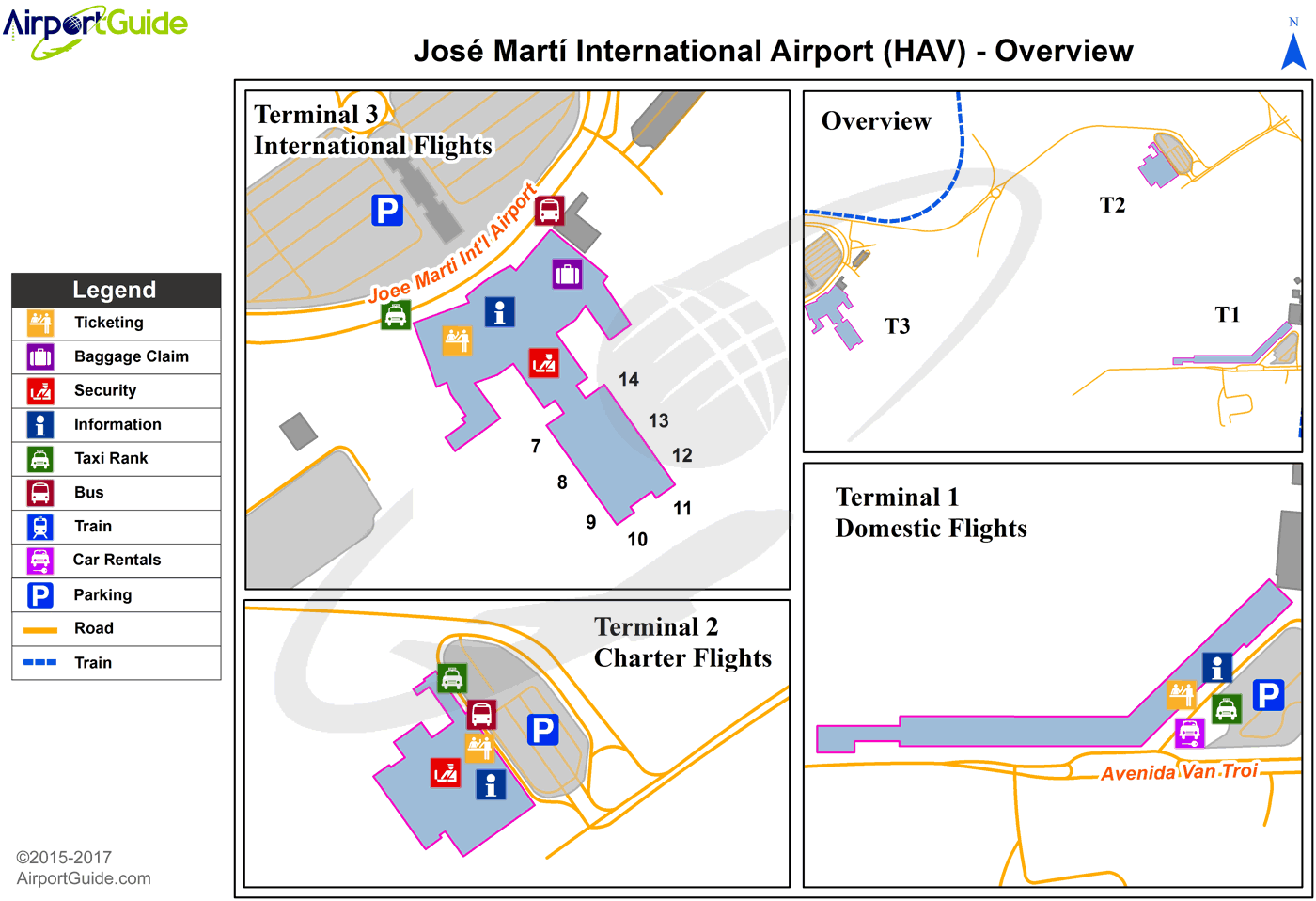
Maps & Diagrams
HAV Sectional
Flight Planning
at skyvector.com
at skyvector.com
