Location
Latitude: |
63-45-59.8190N (63.766616) |
Longitude: |
171-43-58.0220W (-171.732784) |
Elevation: |
29.5 feet MSL (9 m MSL) |
Magnetic Variation: |
4.8 E (as of April 2024 from WMM2020 model) |
Time Zone: |
UTC -9.0 (Standard Time) UTC -8.0 (Daylight Savings Time) |
From City: |
00 N.M. SW of Gambell, Alaska |
Found On: |
Bethel Chart |
FAA Region: |
AAL |
Contacts
Manager: |
Publicly owned: |
| GEORGE KOST BOX 1048 NOME, AK 99762 907-443-2500 |
ALASKA DOT&PF NORTHERN REGION 2301 PEGER RD FAIRBANKS, AK 99709 907-451-2200 |
Operations
Airport Status: |
Operational |
Facility Use: |
Public |
Type: |
Airport |
Activation Date: |
03/1950 |
Control tower: |
No |
Attendance (Months/Days/Hours): |
Months/Days/Hours Unattended |
Boundary ARTCC: |
ZAN (Anchorage) |
Responsible ARTCC: |
ZAN (Anchorage) |
Lighting Schedule: |
SEE RMK |
Segmented Circle Indicator: |
Yes |
Traffic Pattern Altitude (MSL): |
1030 feet (314 m) |
NOTAMs Facility: |
GAM |
NOTAM-D Service: |
Yes |
International Airport of Entry: |
No |
Customs Landing Rights: |
No |
Military Landing Rights: |
Yes |
Civil/Military Joint Use: |
No |
Based Aircraft
Annual Operations (as of 12/31/2022)
| Total Operations: | 1652 | |
| Commercial: | 1652 | 100.0% |
Communications
| CTAF: | 122.700 |
| AWOS-3P: | 125.9 (907-985-5733) |
- APCH/DEP SVC PRVDD BY ANCHORAGE ARTCC ON FREQS 132.2/281.4 (GAMBELL RCAG).
- COMMUNICATIONS PRVDD BY NOME FSS ON FREQ 122.0 (GAMBELL RCO).
Fixed Based Operators (FBOs) & Fuel
(Click on a business for detail)
Please help us keep this information up to date. This is a FREE SERVICE just like everything else on Airport Guide! If you see that a business needs to be added, modified, or deleted please fill out our Update Form.
To add, modify, or delete a business click here.
Please help us keep this information up to date. This is a FREE SERVICE just like everything else on Airport Guide! If you see that a business needs to be added, modified, or deleted please fill out our Update Form.
Area Code: 907 |
| Business Name | Frequency | Phone | Fuel Grade |
|---|
Flight Service Stations
| Primary | Alternate | |
| FSS on Field: | N | |
| FSS Name (ID): | Nome(OME) | Fairbanks (FAI) |
| Frequency: | ||
| Toll Free Phone: | 1-800-478-8400 | 1-866-248-6516 |
Instrument Procedures / Charts
FAA Terminal Procedures valid from 0901Z 03/21/24 to 0901Z 04/18/24.
There are various types of charts available for an airport. They are listed in the Page Type column. Here is a legend for those types:
APD - Airport Diagram
DP - Departure Procedure Charts
HOT - Hot Spots
IAP - Instrument Approach Procedure Charts
MIN - Minimums
STAR - Standard Terminal Arrival Charts
| Page Type | Page Name | Volume | Action Since Last Cycle |
|---|---|---|---|
| IAP | NDB RWY 16 | AK-1 | Changed |
| IAP | NDB/DME RWY 34 | AK-1 | Changed |
| IAP | RNAV (GPS) RWY 16 | AK-1 | |
| IAP | RNAV (GPS) RWY 34 | AK-1 | |
| MIN | ALTERNATE MINIMUMS | AK-1 | |
| MIN | TAKEOFF MINIMUMS | AK-1 |
Terminal Procedures are only available for airports in several countries with more being added all the time. If you are looking for a specific country's charts, please send an email to support(at)airportguide.com stating the country name. This will be used to prioritize the implementation.
Navigation Aids (Navaids) near GAM
Nearby Airports with Fuel
| Dist (NM) | Name (Airport IDs) | True Hdg | Mag Hdg | Fuel Grade |
|---|
Notices to Airmen (NOTAMS)
Remarks
| A110-1 | 98 FT TWR LGTD, 3400 FT FM APCH END RWY 16. |
| A110-2 | RWY 16/34 SAFETY AREAS SOFT & LOOSE GRAVEL. |
| A110-3 | RWY CONDITION NOT MONITORED; RECOMMEND VISUAL INSPECTION PRIOR TO LANDING. |
| A110-4 | WX CAMERA AVBL ON INTERNET AT HTTPS://WEATHERCAMS.FAA.GOV. |
| A110-5 | COLD TEMPERATURE AIRPORT. ALTITUDE CORRECTION REQUIRED AT OR BELOW -27C. |
| A81-APT | ACTVT ODALS RWY 34; REIL RWY 16 & 34; VASI RWY 16 & 34; MIRL 16/34 - CTAF. |
Runways
Runway Summary
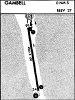
| Runways: | 16/34 |
| Longest Runway: | 16/34 is 4500 ft (1372 m) long |
| Runways with an Instrument Approach: |
GAM Airport Runway Details
| Runway 16/34 | 4500 ft x 100 ft (1372 m x 30 m) | |
| Runway Length Source: | 3RD PARTY SURVEY as of 06/25/2019 | |
| Surface: | Asphalt/Concrete - Fair condition - No special surface treatment | |
| Runway Edge Lights: | Medium Intensity | |
Runway Weight Bearing Capacity (in thousands of pounds) |
||
| Single Wheel Landing Gear: | 22.0 | |
Runway 16 |
Runway 34 |
|
Elevation: |
29.5 | 28.8 |
Latitude: |
63-46-21.7538N | 63-45-37.8840N |
Longitude: |
171-44-04.9322W | 171-43-51.1151W |
|
Runway True Alignment: |
172 | 352 |
Glide Path Angle: |
3.0 degrees | 3.0 degrees |
Traffic Pattern: |
Right | Left |
Runway Markings Type: |
Nonprecision Instrument | Nonprecision Instrument |
Runway Markings Condition: |
Fair | Fair |
Object at End: |
ANT | |
Object Height: |
98 | |
Object Marked/Lighted?: |
Lighted | |
Distance from End: |
3400 | |
Object Centerline Offset: |
250 ft. left of centerline | |
Visual Glide Slope Indicators: |
4-Box VASI On Left Side Of Runway | 4-Box VASI On Right Side Of Runway |
Approach Light System: |
Omnidirectional Approach Lighting System | |
REIL: |
Yes | Yes |
Threshold Crossing Height: |
37 | 39 |
Services
Airframe Repair: |
None |
Powerplant Repair: |
None |
Bottled Oxygen: |
None |
Bulk Oxygen: |
None |
Landing Fees: |
No |
Maps & Diagrams
GAM Sectional
Flight Planning
at skyvector.com
at skyvector.com