Location
Latitude: |
40-58-42.5000N (40.978472) |
Longitude: |
085-11-42.6000W (-85.195167) |
Elevation: |
814.5 feet MSL (248 m MSL) |
Magnetic Variation: |
5.8 W (as of April 2024 from WMM2020 model) |
Time Zone: |
UTC -5.0 (Standard Time) UTC -4.0 (Daylight Savings Time) |
From City: |
07 N.M. SW of Fort Wayne, Indiana |
Found On: |
Chicago Chart |
FAA Region: |
AGL |
Contacts
Manager: |
Publicly owned: |
| SCOTT D. HINDERMAN 3801 WEST FERGUSON ROAD, SUITE 209 FORT WAYNE, IN 46809 260-747-4146 |
FT WAYNE/ALLEN CO ARPT AUTH 3801 WEST FERGUSON ROAD, SUITE 209 FORT WAYNE, IN 46809 260-747-4146 |
Operations
Airport Status: |
Operational |
Facility Use: |
Public |
Type: |
Airport |
Activation Date: |
01/1943 |
Control tower: |
Yes |
Attendance (Months/Days/Hours): |
Months/Days/Hours ALL/ALL/0500-2300 |
Boundary ARTCC: |
ZAU (Chicago) |
Responsible ARTCC: |
ZAU (Chicago) |
Segmented Circle Indicator: |
No |
Traffic Pattern Altitude (MSL): |
1814 feet (553 m) |
NOTAMs Facility: |
FWA |
NOTAM-D Service: |
Yes |
International Airport of Entry: |
No |
Customs Landing Rights: |
No |
Military Landing Rights: |
Yes |
Civil/Military Joint Use: |
No |
Aircraft Rescue and Firefighting: |
Class I ARFF Index: B Air Carrier Service: Scheduled Certification Date: 05/1973 |
Based Aircraft
| Single Engine: | 42 |
| Multi Engine: | 8 |
| Jet Engine: | 16 |
| GA Helicopters: | 2 |
| Military Aircraft: | 21 |
Annual Operations (as of 01/31/2023)
| Total Operations: | 42091 | |
| Commercial: | 8130 | 19.3% |
| Air Taxi: | 10254 | 24.4% |
| GA Local: | 6572 | 15.6% |
| GA Itinerant: | 14413 | 34.2% |
| Military Aircraft: | 2722 | 6.5% |
Communications
| Unicom: | 122.950 |
| Tower: | FORT WAYNE 119.1 269.325 Hrs: 24 |
| Clearance Del.: | 124.75 |
| Ground: | 121.9 348.6 |
| Approach: | FORT WAYNE 127.2 ;SW/NW OF ACTIVE RWY 132.15 ;SE/NE OF ACTIVE RWY 282.325 ;SE/NE OF ACTIVE RWY 284.6 ;SW/NW OF ACTIVE RWY Hrs: 24 135.325 |
| Departure: | FORT WAYNE 127.2 ;SW/NW OF ACTIVE RWY 132.15 ;SE/NE OF ACTIVE RWY 282.325 ;SE/NE OF ACTIVE RWY 284.6 ;SW/NW OF ACTIVE RWY Hrs: 24 135.325 |
| ATIS: | 121.25 360.825 Hrs: 24 |
| ASOS: | (260-479-6621) |
| COMD POST: | 138.625 |
| SFA: | 369.2 |
| EMERG: | 121.5 |
| EMERG: | 243.0 |
| SFA: | 398.2 |
| CLASS C: | 282.325 ;SE/NE OF ACTIVE RWY |
| CLASS C: | 127.2 ;SW/NW OF ACTIVE RWY |
| CLASS C: | 284.6 ;SW/NW OF ACTIVE RWY |
| CLASS C: | 132.15 ;SE/NE OF ACTIVE RWY |
Fixed Based Operators (FBOs) & Fuel
(Click on a business for detail)
Please help us keep this information up to date. This is a FREE SERVICE just like everything else on Airport Guide! If you see that a business needs to be added, modified, or deleted please fill out our Update Form.
To add, modify, or delete a business click here.
Please help us keep this information up to date. This is a FREE SERVICE just like everything else on Airport Guide! If you see that a business needs to be added, modified, or deleted please fill out our Update Form.
Area Code: 219 |
| Business Name | Frequency | Phone | Fuel Grade |
|---|---|---|---|
| Consolidated Airways, Inc.
Update FBO info |
Unicom 123.3 | 747-1626 | 100LL, Jet A |
| Fort Wayne Air Service
Update FBO info |
Unicom 122.95 | 800-334-FWAS, 747-1565 | 100LL, Jet A |
| Premier Avionics, LLC
Website Update FBO info |
260-747-4810 | 100LL, Jet A |
Flight Service Stations
| Primary | Alternate | |
| FSS on Field: | N | |
| FSS Name (ID): | Terre Haute(HUF) | |
| Frequency: | ||
| Toll Free Phone: | 1-800-WX-BRIEF |
Instrument Procedures / Charts
FAA Terminal Procedures valid from 0901Z 03/21/24 to 0901Z 04/18/24.
There are various types of charts available for an airport. They are listed in the Page Type column. Here is a legend for those types:
APD - Airport Diagram
DP - Departure Procedure Charts
HOT - Hot Spots
IAP - Instrument Approach Procedure Charts
MIN - Minimums
STAR - Standard Terminal Arrival Charts
| Page Type | Page Name | Volume | Action Since Last Cycle |
|---|---|---|---|
| APD | AIRPORT DIAGRAM | EC-2 | |
| HOT | HOT SPOT | EC-2 | |
| IAP | ILS OR LOC RWY 05 | EC-2 | |
| IAP | ILS OR LOC RWY 32 | EC-2 | |
| IAP | ILS RWY 05 (CAT II) | EC-2 | |
| IAP | RNAV (GPS) RWY 05 | EC-2 | |
| IAP | RNAV (GPS) RWY 14 | EC-2 | |
| IAP | RNAV (GPS) RWY 23 | EC-2 | |
| IAP | RNAV (GPS) RWY 32 | EC-2 | |
| IAP | VOR OR TACAN RWY 05 | EC-2 | |
| IAP | VOR OR TACAN RWY 14 | EC-2 | Changed |
| IAP | VOR OR TACAN RWY 23 | EC-2 | |
| MIN | ALTERNATE MINIMUMS | EC-2 | |
| MIN | RADAR MINIMUMS | EC-2 | |
| MIN | TAKEOFF MINIMUMS | EC-2 |
Terminal Procedures are only available for airports in several countries with more being added all the time. If you are looking for a specific country's charts, please send an email to support(at)airportguide.com stating the country name. This will be used to prioritize the implementation.
Navigation Aids (Navaids) near FWA
| Dist (NM) | ID | Morse Code | Name | Type | Freq | True Hdg | Mag Hdg |
|---|---|---|---|---|---|---|---|
| 0.2 | FWA | . . _ . . _ _ . _ | Fort Wayne Baer | VOT | 111.00 | 95 | 101 |
| 0.3 | FWA | . . _ . . _ _ . _ | Fort Wayne | VORTAC | 117.80 | 83 | 89 |
| 14.2 | HHG | . . . . . . . . _ _ . | Huntington | NDB | 417 | 238 | 244 |
| 21.1 | OLK | _ _ _ . _ . . _ . _ | Webster Lake | VOR | 110.40 | 319 | 325 |
| 22.8 | GW | _ _ . . _ _ | Shenk | NDB | 227 | 29 | 35 |
| 27.2 | VFU | . . . _ . . _ . . . _ | Stanley | NDB | 411 | 104 | 110 |
| 30.2 | IWH | . . . _ _ . . . . | Wabash | NDB | 329 | 244 | 250 |
| 36.5 | MZZ | _ _ _ _ . . _ _ . . | Marion | VOR-DME | 108.60 | 217 | 223 |
| 40.0 | ANQ | . _ _ . _ _ . _ | Angola | NDB | 347 | 6 | 12 |
| 41.4 | CQA | _ . _ . _ _ . _ . _ | Lakefield | NDB | 205 | 135 | 141 |
| 45.4 | MIE | _ _ . . . | Muncie | VOR-DME | 114.40 | 191 | 197 |
| 47.6 | OKK | _ _ _ _ . _ _ . _ | Kokomo | TACAN | 113.50 | 235 | 240 |
| 47.8 | GUS | _ _ . . . _ . . . | Grissom | VORTAC | 108.45 | 245 | 250 |
| 48.2 | JN | . _ _ _ _ . | Balll | NDB | 365 | 186 | 192 |
| 49.9 | GSH | _ _ . . . . . . . . | Goshen | VORTAC | 113.70 | 311 | 317 |
| 51.2 | IRS | . . . _ . . . . | Sturgis | NDB | 382 | 347 | 353 |
| 55.7 | CPB | _ . _ . . _ _ . _ . . . | Culver | NDB | 391 | 285 | 290 |
| 56.4 | AI | . _ . . | Video | NDB | 394 | 194 | 200 |
| 58.0 | AOH | . _ _ _ _ . . . . | Allen County | VOR | 108.40 | 105 | 111 |
| 61.0 | USE | . . _ . . . . | Fulton | NDB | 375 | 51 | 57 |
Nearby Airports with Fuel
Notices to Airmen (NOTAMS)
Remarks
| A110-1 | BIRDS ON & INVOF ARPT. |
| A110-10 | ANG: PRK RAMP NSTD MRK INCL SOLID WHITE WINGTIP CLNC LINES BOTH SIDES OF TXL LCTD BTN E & W PRK ROWS, E & W OF BLDG 800 & MULT WHITE BOXES FOR ACFT GRD EQPT & MUNITIONS STORAGE AREA. |
| A110-11 | ANG: UNUSE PAVEMENT FOR TAX LCTD CNTR OF APN WEST OF RSTD AREA - OPS FOR INFO. |
| A110-12 | A-GEAR FOR LCL 122FW ONLY, PPR DSN 778-3202/3203 C800-842-3104 EXTN 202/203. |
| A110-2 | TWY M & EAST RAMP MIL USE ONLY; OTR BY REQUEST - ANG 260-478-3202. |
| A110-5 | TWY B ARM/DEARM AREA RSTRD TO MIL ACFT. |
| A110-6 | ATCT PPR FOR PUSHBACK AT BOARDING GATES 2 & 3; PUSH BACK INTO TWY C MOV AREA. |
| A110-9 | TWY B/B, 1/B, 2/E & K CLSD TO WINGSPAN 79 FT OR GTR & WITH DUAL WHEEL TYPE LNDG GEAR IN EXCESS OF 50000 LB. |
| A17 | AFT HR SVC - 260-747-2624. |
| A26 | ARFF INDEX C AVBL UPON REQ - 260-747-2624. |
| A30-09/27 | AVBL FOR TAX ONLY AT NIGHT. AVBL FOR SKED ACR OPS WITH MORE THAN 9 PAX SEATS OR UNSKED ACR OPS WITH AT LEAST 31 PAX SEATS. |
| A70-FUEL-10 | 0LL NC-100LL, A - CALLOUT FEE 0400-1000Z++. |
| A81-BCN | ATC-CTL |
| E60-14 | BAK-12(B) (1650 FT). |
| E80 | US CUSTOMS USER FEE ARPT. |
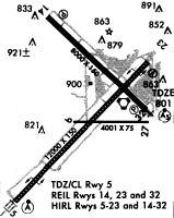
Runways
Runway Summary
| Runways: | 05/23 09/27 14/32 |
| Longest Runway: | 05/23 is 11981 ft (3652 m) long |
| Runways with an Instrument Approach: | 05, 32 |
FWA Airport Runway Details
| Runway 05/23 | 11981 ft x 150 ft (3652 m x 46 m) | |
| Runway Length Source: | 3RD PARTY SURVEY as of 04/10/2010 | |
| Surface: | Asphalt/Concrete - Good condition - Saw-cut or plastic grooved | |
| Runway Pavement Class: | 59 /R/C/W/T | |
| Runway Edge Lights: | High Intensity | |
Runway Weight Bearing Capacity (in thousands of pounds) |
||
| Single Wheel Landing Gear: | 120.0 | |
| Dual Wheel Landing Gear: | 203.0 | |
| Dual Tandem Wheel Landing Gear: | 357.0 | |
| Dual Dual Tandem Wheel Landing Gear: | 847.0 | |
Runway 05 |
Runway 23 |
|
Elevation: |
814.5 | 798.5 |
Latitude: |
40-57-45.6713N | 40-59-10.4415N |
Longitude: |
085-12-45.6915W | 085-10-56.6748W |
|
Runway True Alignment: |
044 | 224 |
ILS Type: |
ILS | |
Glide Path Angle: |
0.0 degrees | 3.0 degrees |
Traffic Pattern: |
Left | Left |
Runway Markings Type: |
Precision Instrument | Nonprecision Instrument |
Runway Markings Condition: |
Good | Good |
Object at End: |
RR | |
Object Height: |
23 | |
Distance from End: |
800 | |
Object Centerline Offset: |
585 ft. left of centerline | |
Visual Glide Slope Indicators: |
4-Light PAPI On Left Side Of Runway | |
Runway Visual Range (RVR): |
Touchdown, Midfield, Rollout | Touchdown, Midfield, Rollout |
Approach Light System: |
Standard 2,400 Foot High Intensity Approach Lighting System With Sequenced Flashers, Cat. II or III Config. | |
REIL: |
Yes | |
Touchdown Lights: |
Yes | No |
Centerline Lights: |
Yes | Yes |
Threshold Crossing Height: |
76 | |
Declared Distances |
||
Take Off Run Avbl. (TORA): |
11981 | 11981 |
Take Off Distance Avbl. (TODA): |
11981 | 11981 |
Actual Stop Dist. Avbl. (ASDA): |
11981 | 11981 |
Landing Dist. Avbl. (LDA): |
11981 | 11981 |
| Runway 09/27 | 4001 ft x 75 ft (1220 m x 23 m) | |
| Runway Length Source: | 3RD PARTY SURVEY as of 04/10/2010 | |
| Surface: | Asphalt/Concrete - Good condition - No special surface treatment | |
| Runway Pavement Class: | 35 /F/C/W/U | |
Runway Weight Bearing Capacity (in thousands of pounds) |
||
| Single Wheel Landing Gear: | 100.0 | |
| Dual Wheel Landing Gear: | 190.0 | |
| Dual Tandem Wheel Landing Gear: | 215.0 | |
| Dual Dual Tandem Wheel Landing Gear: | 430.0 | |
Runway 09 |
Runway 27 |
|
Elevation: |
798.4 | 793.4 |
Latitude: |
40-58-33.1319N | 40-58-33.0681N |
Longitude: |
085-11-55.6164W | 085-11-03.4693W |
|
Runway True Alignment: |
090 | 270 |
Glide Path Angle: |
0.0 degrees | 0.0 degrees |
Runway Markings Type: |
Basic | Basic |
Runway Markings Condition: |
Good | Good |
Object Centerline Offset: |
585 ft. left of centerline | |
Declared Distances |
||
Take Off Run Avbl. (TORA): |
4001 | 4001 |
Take Off Distance Avbl. (TODA): |
4001 | 4001 |
Actual Stop Dist. Avbl. (ASDA): |
4001 | 4001 |
Landing Dist. Avbl. (LDA): |
4001 | 4001 |
| Runway 14/32 | 8002 ft x 150 ft (2439 m x 46 m) | |
| Runway Length Source: | 3RD PARTY SURVEY as of 04/10/2010 | |
| Surface: | Asphalt/Concrete - Good condition - Saw-cut or plastic grooved | |
| Runway Pavement Class: | 54 /F/C/W/T | |
| Runway Edge Lights: | High Intensity | |
Runway Weight Bearing Capacity (in thousands of pounds) |
||
| Single Wheel Landing Gear: | 120.0 | |
| Dual Wheel Landing Gear: | 189.0 | |
| Dual Tandem Wheel Landing Gear: | 326.0 | |
| Dual Dual Tandem Wheel Landing Gear: | 799.0 | |
Runway 14 |
Runway 32 |
|
Elevation: |
801.6 | 796.4 |
Latitude: |
40-59-36.6702N | 40-58-41.0064N |
Longitude: |
085-12-13.1863W | 085-10-59.0928W |
|
Runway True Alignment: |
135 | 315 |
ILS Type: |
ILS/DME | |
Glide Path Angle: |
3.0 degrees | 3.0 degrees |
Traffic Pattern: |
Left | Left |
Runway Markings Type: |
Nonprecision Instrument | Precision Instrument |
Runway Markings Condition: |
Good | Good |
Arresting Device: |
BAK-12 | |
Object at End: |
TREE | RR |
Object Height: |
100 | 26 |
Distance from End: |
3672 | 1084 |
Object Centerline Offset: |
585 ft. left of centerline | |
Visual Glide Slope Indicators: |
4-Light PAPI On Left Side Of Runway | 4-Light PAPI On Left Side Of Runway |
Runway Visual Range (RVR): |
Rollout | Touchdown |
Approach Light System: |
1,400 Foot Medium Intensity Approach Lighting System With Runway Alignment Indicator Lights | |
REIL: |
Yes | |
Touchdown Lights: |
No | No |
Centerline Lights: |
No | No |
Threshold Crossing Height: |
53 | 76 |
Declared Distances |
||
Take Off Run Avbl. (TORA): |
8001 | 8001 |
Take Off Distance Avbl. (TODA): |
8001 | 8001 |
Actual Stop Dist. Avbl. (ASDA): |
8001 | 8001 |
Landing Dist. Avbl. (LDA): |
8001 | 8001 |
Services
Fuel Available: |
100LL, UL94 |
Landing Fees: |
No |
Parking: |
Tiedowns available |
Maps & Diagrams
FWA Sectional
Flight Planning
at skyvector.com
at skyvector.com