Location
Latitude: |
41-40-35.6380N (41.676566) |
Longitude: |
070-57-28.2100W (-70.957836) |
Elevation: |
79.1 feet MSL (24 m MSL) |
Magnetic Variation: |
14 W (as of April 2024 from WMM2020 model) |
Time Zone: |
UTC -5.0 (Standard Time) UTC -4.0 (Daylight Savings Time) |
From City: |
02 N.M. NW of New Bedford, Massachusetts |
Found On: |
New York Chart |
FAA Region: |
ANE |
Contacts
Manager: |
Publicly owned: |
| SCOT SERVIS 1569 AIRPORT RD NEW BEDFORD, MA 02746 508-991-6161 |
CITY OF NEW BEDFORD WILLIAMS ST NEW BEDFORD, MA 02740 508-979-1410 |
Operations
Airport Status: |
Operational |
Facility Use: |
Public |
Type: |
Airport |
Activation Date: |
04/1942 |
Control tower: |
Yes |
Attendance (Months/Days/Hours): |
Months/Days/Hours ALL/ALL/0600-2300 |
Boundary ARTCC: |
ZBW (Boston) |
Responsible ARTCC: |
ZBW (Boston) |
Lighting Schedule: |
SEE RMK |
Segmented Circle Indicator: |
No |
Traffic Pattern Altitude (MSL): |
1079 feet (329 m) |
NOTAMs Facility: |
EWB |
NOTAM-D Service: |
Yes |
International Airport of Entry: |
No |
Customs Landing Rights: |
Yes |
Military Landing Rights: |
Yes |
Civil/Military Joint Use: |
No |
Aircraft Rescue and Firefighting: |
Class IV ARFF Index: A Air Carrier Service: Not Scheduled Certification Date: 07/2017 |
Based Aircraft
| Single Engine: | 85 |
| Multi Engine: | 13 |
| Jet Engine: | 3 |
| GA Helicopters: | 3 |
Annual Operations (as of 10/31/2022)
| Total Operations: | 48853 | |
| Commercial: | 1 | 0.0% |
| Air Taxi: | 3859 | 7.9% |
| GA Local: | 23457 | 48.0% |
| GA Itinerant: | 18718 | 38.3% |
| Military Aircraft: | 2818 | 5.8% |
Communications
| CTAF: | 118.100 |
| Unicom: | 122.950 |
| Tower: | NEW BEDFORD 118.1 239.0 Hrs: 0630-2200 |
| Ground: | 121.9 |
| Approach: | PROVIDENCE BOSTON ARTCC |
| Departure: | PROVIDENCE BOSTON ARTCC |
| ATIS: | 126.85 Hrs: 24 |
| ASOS: | 126.85 (508-992-0195) |
| EMERG: | 121.5 |
| EMERG: | 243.0 |
- APCH/DEP SVC PRVDD BY BOSTON ARTCC ON FREQS 124.85/307.9 (WOODSTOCK RCAG) WHEN PROVIDENCE APCH CTL CLSD.
Fixed Based Operators (FBOs) & Fuel
(Click on a business for detail)
Please help us keep this information up to date. This is a FREE SERVICE just like everything else on Airport Guide! If you see that a business needs to be added, modified, or deleted please fill out our Update Form.
To add, modify, or delete a business click here.
Please help us keep this information up to date. This is a FREE SERVICE just like everything else on Airport Guide! If you see that a business needs to be added, modified, or deleted please fill out our Update Form.
Area Code: 508 |
| Business Name | Frequency | Phone | Fuel Grade |
|---|---|---|---|
| Colonial Air
Update FBO info |
Unicom 122.95 | 997-0620 | 100LL, Jet A |
| Nor East Aviation Services, Inc.
Website Update FBO info |
Unicom 122.77 | 996-1832 | 100LL, Jet A |

|
 Exxon |
100LL - 2.56 USD per gallon on 8/23/01 |
Pumps or Trucks Discount available for volume. Please call for details. |
|
|
Exxon |
Jet A - 2.15 USD per gallon on 8/23/01 |
Pumps or Trucks Discount available for volume. Please call for details. |
| Sandpiper Air
Update FBO info |
997-6596 | 100LL, Jet A |
Flight Service Stations
| Primary | Alternate | |
| FSS on Field: | N | |
| FSS Name (ID): | Bridgeport(BDR) | |
| Frequency: | ||
| Toll Free Phone: | 1-800-WX-BRIEF |
Instrument Procedures / Charts
FAA Terminal Procedures valid from 0901Z 03/21/24 to 0901Z 04/18/24.
There are various types of charts available for an airport. They are listed in the Page Type column. Here is a legend for those types:
APD - Airport Diagram
DP - Departure Procedure Charts
HOT - Hot Spots
IAP - Instrument Approach Procedure Charts
MIN - Minimums
STAR - Standard Terminal Arrival Charts
| Page Type | Page Name | Volume | Action Since Last Cycle |
|---|---|---|---|
| APD | AIRPORT DIAGRAM | NE-1 | |
| IAP | ILS OR LOC RWY 05 | NE-1 | |
| IAP | LOC BC RWY 23 | NE-1 | |
| IAP | RNAV (GPS) RWY 05 | NE-1 | |
| IAP | RNAV (GPS) RWY 14 | NE-1 | |
| IAP | RNAV (GPS) RWY 23 | NE-1 | |
| IAP | RNAV (GPS) RWY 32 | NE-1 | |
| MIN | ALTERNATE MINIMUMS | NE-1 | |
| MIN | TAKEOFF MINIMUMS | NE-1 | |
| STAR | WIPOR THREE (RNAV) | NE-1 |
Terminal Procedures are only available for airports in several countries with more being added all the time. If you are looking for a specific country's charts, please send an email to support(at)airportguide.com stating the country name. This will be used to prioritize the implementation.
Navigation Aids (Navaids) near EWB
| Dist (NM) | ID | Morse Code | Name | Type | Freq | True Hdg | Mag Hdg |
|---|---|---|---|---|---|---|---|
| 12.2 | TAN | _ . _ _ . | Taunton | NDB | 227 | 347 | 361 |
| 19.4 | AR | . _ . _ . | Armin | NDB | 356 | 294 | 308 |
| 19.9 | FMH | . . _ . _ _ . . . . | Otis | TACAN | 115.80 | 92 | 106 |
| 21.2 | PVD | . _ _ . . . . _ _ . . | Providence | VOT | 108.20 | 277 | 291 |
| 21.3 | PVD | . _ _ . . . . _ _ . . | Providence | VOR-DME | 115.60 | 277 | 291 |
| 22.3 | IHM | . . . . . . _ _ | Mansfield | NDB | 220 | 331 | 345 |
| 22.9 | MVY | _ _ . . . _ _ . _ _ | Marthas Vineyard | VOR-DME | 114.50 | 137 | 151 |
| 23.4 | FM | . . _ . _ _ | Bomde | NDB | 362 | 81 | 95 |
| 27.7 | OW | _ _ _ . _ _ | Stoge | NDB | 397 | 344 | 358 |
| 28.3 | IMR | . . _ _ . _ . | Marshfield | NDB | 368 | 26 | 40 |
| 40.4 | PVC | . _ _ . . . . _ _ . _ . | Provincetown | NDB | 389 | 54 | 68 |
| 40.9 | BOS | _ . . . _ _ _ . . . | Boston | VOT | 111.00 | 357 | 371 |
| 40.9 | BOS | _ . . . _ _ _ . . . | Boston | VOR-DME | 112.70 | 358 | 372 |
| 41.3 | SEY | . . . . _ . _ _ | Sandy Point | VOR-DME | 117.80 | 222 | 236 |
| 43.0 | PUT | . _ _ . . . _ _ | Putnam | VOR-DME | 117.40 | 293 | 307 |
| 43.5 | CQX | _ . _ . _ _ . _ _ . . _ | Nauset | NDB | 279 | 88 | 102 |
| 45.9 | LFV | . _ . . . . _ . . . . _ | Marconi | VOR-DME | 114.70 | 63 | 77 |
| 46.5 | LQ | . _ . . _ _ . _ | Lyndy | NDB | 382 | 359 | 373 |
| 47.3 | ORW | _ _ _ . _ . . _ _ | Norwich | VOR-DME | 110.00 | 261 | 275 |
| 47.8 | SKR | . . . _ . _ . _ . | Shaker Hill | NDB | 251 | 348 | 362 |
Nearby Airports with Fuel
Notices to Airmen (NOTAMS)
Remarks
| A110-1 | BIRDS & WILDLIFE ON & INVOF ARPT. |
| A110-2 | LDG FEES FOR ACFT OVR 3000 LBS. |
| A110-3 | FOR CD WHEN APCH CLSD CTC BOSTON ARTCC AT 603-879-6859. |
| A110-4 | ARPT CLSD TO NON SKED ACR ACFT WITH MORE THAN 31 PAX EXC 48 HR PPR 508-991-6161. |
| A110-5 | TWYS A1 & A2 FOR ACR ACFT ONLY. |
| A57-23 | APCH SLP 50:1 AT DTHR. |
| A81-APT | WHEN ATCT CLSD ACTVT MALSR RWYS 05 & 23; REIL RWY 32; HIRL RWY 05/23; MIRL RWY 14/32 - CTAF. PAPI RWYS 14, 23 & 32 OPR 24 HRS. |
| E111 | PRVDD APCH/DEP SFCS CONFORM WITH TERPS & FAR PART 77. |
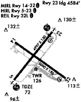
Runways
Runway Summary
| Runways: | 05/23 14/32 |
| Longest Runway: | 05/23 is 5400 ft (1646 m) long |
| Runways with an Instrument Approach: | 05 |
EWB Airport Runway Details
| Runway 05/23 | 5400 ft x 150 ft (1646 m x 46 m) | |
| Runway Length Source: | 3RD PARTY SURVEY as of 09/30/2018 | |
| Surface: | Asphalt - Good condition - Saw-cut or plastic grooved | |
| Runway Edge Lights: | High Intensity | |
Runway Weight Bearing Capacity (in thousands of pounds) |
||
| Single Wheel Landing Gear: | 30.0 | |
| Dual Wheel Landing Gear: | 108.0 | |
| Dual Tandem Wheel Landing Gear: | 195.0 | |
Runway 05 |
Runway 23 |
|
Elevation: |
64.4 | 79.1 |
Latitude: |
41-40-16.5377N | 41-40-58.3207N |
Longitude: |
070-57-53.8838W | 070-57-09.6422W |
|
Runway True Alignment: |
038 | 218 |
ILS Type: |
ILS/DME | |
Glide Path Angle: |
0.0 degrees | 3.0 degrees |
Traffic Pattern: |
Left | Left |
Runway Markings Type: |
Precision Instrument | Precision Instrument |
Runway Markings Condition: |
Good | Good |
Object at End: |
TREE | TREE |
Object Height: |
20 | 35 |
Distance from End: |
1200 | 1400 |
Object Centerline Offset: |
125 ft. left and right of centerline | |
Visual Glide Slope Indicators: |
4-Light PAPI On Left Side Of Runway | |
Runway Visual Range (RVR): |
Touchdown | Rollout |
Approach Light System: |
1,400 Foot Medium Intensity Approach Lighting System With Runway Alignment Indicator Lights | 1,400 Foot Medium Intensity Approach Lighting System With Runway Alignment Indicator Lights |
Threshold Crossing Height: |
46 | |
Threshold Elevation: |
78.0 | |
Displaced Threshold: |
400 | |
Threshold Latitude: |
41-40-55.2273N | |
Threshold Longitude: |
070-57-12.9192W |
| Runway 14/32 | 5002 ft x 75 ft (1525 m x 23 m) | |
| Runway Length Source: | 3RD PARTY SURVEY as of 09/30/2018 | |
| Surface: | Asphalt - Good condition - No special surface treatment | |
| Runway Edge Lights: | Medium Intensity | |
Runway Weight Bearing Capacity (in thousands of pounds) |
||
| Single Wheel Landing Gear: | 33.0 | |
| Dual Wheel Landing Gear: | 48.0 | |
| Dual Tandem Wheel Landing Gear: | 95.0 | |
Runway 14 |
Runway 32 |
|
Elevation: |
77.3 | 66.2 |
Latitude: |
41-40-49.0807N | 41-40-18.3255N |
Longitude: |
070-57-50.1689W | 070-56-58.5788W |
|
Runway True Alignment: |
128 | 308 |
Glide Path Angle: |
3.4 degrees | 3.5 degrees |
Traffic Pattern: |
Left | Left |
Runway Markings Type: |
Basic | Basic |
Runway Markings Condition: |
Good | Good |
Object at End: |
TREE | TREES |
Object Height: |
10 | 11 |
Distance from End: |
400 | 600 |
Object Centerline Offset: |
125 ft. left and right of centerline | |
Visual Glide Slope Indicators: |
4-Light PAPI On Left Side Of Runway | 4-Light PAPI On Left Side Of Runway |
REIL: |
Yes | |
Threshold Crossing Height: |
50 | 50 |
Services
Airframe Repair: |
Major |
Powerplant Repair: |
Minor |
Bottled Oxygen: |
None |
Bulk Oxygen: |
None |
Fuel Available: |
100LL, Jet A, Jet A+ |
Landing Fees: |
No |
Parking: |
Hangars and tiedowns available |
Maps & Diagrams
EWB Sectional
Flight Planning
at skyvector.com
at skyvector.com